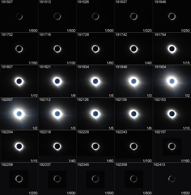
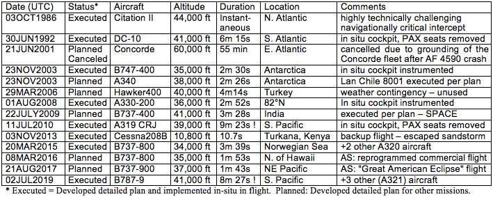
it is for the geographically remote TSE 04 December 2021 (Saturday) UTC.
TOTAL SOLAR ECLIPSE AIRBORNE-INTERCEPT FLIGHT
04 DECEMBER 2021 UTC
DESIGNATED: EFLIGHT 2021–SUNRISE
Developed by Dr. Glenn Schneider*
Steward Observatory and the Department of Astronomy, The University of Arizona
Phone: 520-621-5865, email: gschneider@as.arizona.edu
*A Collaborative Undertaking and Flight Project Planned and Implemented by:
Glenn Schneider (U. Arizona), Tim Todd (T.E.I. Tours & Travel), John Beattie (Project Specialist), and LATAM Airlines
A Spectacular Total Solar Eclipse 2021 Observation Flight Opportunity:
Intercepting the Moon’s Earth-Grazing Umbral Shadow Axis at 39,000 ft.
Launched from Punta Arenas in Southern Chile
| UPDATE (2/13/2020) - We are now planning a SECOND EFLIGHT 2021–SUNRISE aircraft to formation-fly to observe the eclipse in tandem with our already committed first aircraft as described herein. The exact intercept locations and UTCs for the second aircraft will be slightly different (offset) from the first but otherwise will be as described below for the first aircraft. |
A total solar eclipse (TSE)
is,
unequivocally, one of nature’s grandest spectacles and most awe-inspiring
events that we can see with our own eyes! But, the elusiveness of
the path of totality for TSE 2021 (Figure 1) has left many
eclipse-chasers
fretting and asking “how the heck am I going to get there?” We now can
answer as we have planned and are vigorously pursuing a unique
opportunity to
view the eclipse
from a high-altitude jetliner in a near-sunrise
moonshadow rendezvous, above the otherwise high-probability occurrence
of clouds below.

Figure
1. TSE 2021 path of totality and EFLIGHT
2021–SUNRISE circumstances tabulation.
Yellow "+" marks the location of our on-centerline Mid-Eclipse Intercept (MEI) for our ex-Punta Arenas Airbus A321-200 eclipse-flight charter.
By comparison, on the Earth's surface, at the much more distant point of greatest duration (GD) eclipse, totality is only 9 seconds longer than will be seen from our aircraft.
See HERE for the representative extent of circum-Antarctic sea-ice extrusion for early December.
The
TSE 2021 Path of Totality
The location of the “path of totality” (PoT), the only region from
where the eclipse can be seen as total, is dictated by the inexorable
laws of celestial mechanics that heed no geographical or geopolitical
boundaries. In
order to see the eclipse as total (i.e., “totality”) – a truly amazing
and awe-inspiring celestial phenomenon like no other – one must be
within the PoT that the Moon’s shadow traces out as it sweeps over a
small sliver of the Earth’s surface (see Figure 1). An observer located
within the PoT at the right moment in time will be enveloped by, and
immersed within, the Moon’s umbral shadow for the fleeting few moments
of its passage. The width of the path is defined by its northern and
southern limits (pink lines in Figure 1), outside of which the eclipse
will be seen only as
partial, or not at all. (Unlike many PoTs, for TSE 2021 the lunar
shadow traverse on the Earth is primarily “backwards”, from East to West, as it passes over the South Pole
before reaching the surface of the Earth.)
Observing TSE 2021 from the surface of the Earth within its PoT poses significant logistical challenges. If ever there was a TSE in need of an airborne viewing option, it is TSE 04 December 2021 for which totality is visible only over remote and difficult-to-reach areas of Antarctica, parts of the ice-strewn Weddell and oft-foggy Scotia Seas (partially inclusive of some of the South Orkney Islands), and a small stretch of the south Atlantic Ocean southeast of the Falkland (Malvinas) Islands. These very few noted land- or ocean-based “options”, however, have quite adverse prospects with respect to eclipse visibility (weather), remoteness (and prevailing winds), and cost of access, where totality might otherwise be seen. A number of ships will be headed to locations accessible in the Scotia and northern Weddell Seas where the circum-Antarctic pack ice is not impenetrable, though the likelihood of cloudiness will be quite high (see analysis by eclipse weather expert Jay Anderson). While some undeterred umbraphiles will assuredly take up these challenges, there unquestionably will be a much larger constituency, and very high demand, for an eclipse flight for TSE 2021 – and specifically as we have designed and are working now to implement with our aircraft provider LATAM Airlines.
Observing TSE 2021 from the surface of the Earth within its PoT poses significant logistical challenges. If ever there was a TSE in need of an airborne viewing option, it is TSE 04 December 2021 for which totality is visible only over remote and difficult-to-reach areas of Antarctica, parts of the ice-strewn Weddell and oft-foggy Scotia Seas (partially inclusive of some of the South Orkney Islands), and a small stretch of the south Atlantic Ocean southeast of the Falkland (Malvinas) Islands. These very few noted land- or ocean-based “options”, however, have quite adverse prospects with respect to eclipse visibility (weather), remoteness (and prevailing winds), and cost of access, where totality might otherwise be seen. A number of ships will be headed to locations accessible in the Scotia and northern Weddell Seas where the circum-Antarctic pack ice is not impenetrable, though the likelihood of cloudiness will be quite high (see analysis by eclipse weather expert Jay Anderson). While some undeterred umbraphiles will assuredly take up these challenges, there unquestionably will be a much larger constituency, and very high demand, for an eclipse flight for TSE 2021 – and specifically as we have designed and are working now to implement with our aircraft provider LATAM Airlines.
TOP 10 REASONS FOR A HIGH-ALTITUDE
TSE 2021 ECLIPSE FLIGHT
| 1. DEPLOYMENT/RELOCATION FLEXIBILITY To Provide Otherwise Dauntingly Difficult Access to the TSE 2021 PoT |
2. CLOUD OBSCURATION AVOIDANCE At 39,000 ft Cloud-Free Skies are Virtually Assured |
| 3. UNPARALLELED HORIZON REACH &
OBSERVATION VISTA Apparent Horizon 390 km Distant, Depressed 3.5° (at 39,000 ft) |
4. AMAZING VIEWS OF THE UMBRA APPROACH
&
RECESSION Simultaneously in the Dark Sky Above and on the Clouds & Ocean Surface Far Below |
| 5. TOTALITY PROLONGATION FOR LONGER
DURATION Aircraft Speed Extends the Duration of Totality |
6. SKY DARKNESS Much Higher Contrast Coronal and Visibility to Larger Circumsolar Distance |
| 7. SKY TRANSPARENCY Very Low Particulate and Aerosol Atmospheric Scattering |
8.
PANCHROMATIC VISIBILITY Infrared and Ultraviolet "Windows" Open Up or are Extended |
| 9. IMPROVED ASTRONOMICAL SEEING "R_naught" Decreases with Increasing Altitude |
10.
REDUCED ATMOSPHERIC TURBIDITY Vorticity & Sheer Decline in Power Above Lower Troposphere |
EFLIGHT
2021–SUNRISE: A Unique Horizon-Venue “Sunrise” Totality
- We are maturing an A321-200 aircraft
charter of ~ 5-1/2 hour total flight duration,
originating from and returning to Punta Arenas, Chile (PUQ) on
Saturday, December 4, 2021 UTC.
- The purpose of this charter is to provide a high-altitude
(baseline 39,000 ft AMSL) airborne platform to optimally observe the
otherwise geographically remote and logistically challenging TSE of
that date.
- We are advantageously levering the location and
serendipitously relative proximity of the total-eclipse sunrise line
(at the northern end of the path) to Punta Arenas to implement the flight
concept that we designate as EFLIGHT 2021–SUNRISE.
- EFLIGHT 2021–SUNRISE
enables and provides a very
different, exciting, and
breathtaking eclipse-viewing opportunity. From our aircraft totality
will be seen with the totally-eclipsed Sun very low (7
solar diameters at mid-totality) above the 3.5° depressed
terrestrial horizon. Concurrently, the long, dark, conical umbral
shadow will sweep over our aircraft with its axis tangent to
the surface of the Earth. This will be a truly amazing sight to behold.
As with
all our prior
EFLIGHTs, we will centrally
intercept the Moon’s umbral shadow at the selected instant of
mid-totality along the
centerline of the PoT. This time, we are designing our flight plan to
optimize that
experience very near the sunrise
(northern) extremum of the PoT. This is
where center of the Moon’s umbral shadow axis first touches down upon,
and there is tangent to, the surface of the Earth. From this location
the Sun
is framed in total eclipse on the terrestrial
horizon that is depressed (“dipped”) below the unobscured
horizontal-plane of the astronomical
horizon by 3.5° thanks to the aircraft’s
altitude.
EFLIGHT
Charter Plan in Progress
The
proximity of the PoT’s northern sunrise line to both the Punta
Arenas
(as a launch point) and Mt. Pleasant (Falkland/Malvinas Islands)
airports fortuitously permits us to employ a well-suited,
single-aisle, A321-200 aircraft that is available for charter in the
region operating under ETOPS60
rules, and is more economical than a wide-body. ETOPS (Extended-range
Twin-engine Operation Performance
Standards) 60 provides the requisite safe-return operational “reach” of
the
A321-200 to the sunrise limit of the PoT through the planned
(contingency, but highly unlikely) use of Mt. Pleasant airport as a “single-engine-out”
diversionary return airport. In our case, ETOPS60
provides
us with a nearest contingency landing facility (Mt. Pleasant) that both
satisfies safety requirements and which is
(more than) sufficient to plan an optimal “sunrise” MEI.
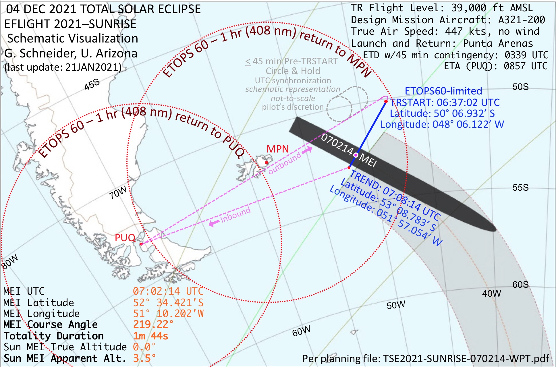
This is schematically illustrated in Figure 2. Adopting this
plan, we are now in the
process of arranging and working out all of the details for our EFLIGHT
2021–SUNRISE eclipse-viewing/charter with the
aircraft
provider/operator, LATAM Airlines, per our detailed
specifications. The A321-200 aircraft we are arranging meets (and
exceeds) all
of our technical requirements and is ideal
for this flight scenario.
AMSL Above Mean Sea Level
ETA Estimated Time of Arrival
ETD Estimated Time of Departure
ETOPS Extended-range Twin-engine Operating Performance Standards
MEI Mid-Eclipse Intercept
MPN Mount Pleasant airport code
PUQ Punta Arenas airport code
TR Totality Run
TREND Totality Run End
TRSTART Totality Run Start (405.4 nm from MPN)
UTC Universal Time (Coordinated)

Figure 2. Graphic schematic overview
of the EFLIGHT 2021–SUNRISE
charter
concept.
Red dotted circles show overlapping
ETOPS60 operating limits for PUQ
and MPN reaching and enclosing the sunrise limit of the PoT.
Purple dashed lines respectively represent the outbound (longer) and inbound (shorter) cruise phases to and from the “Totality Run” start and end points.
Gray dashed pattern represents an up to 45-minute “circle and hold” to synchronize to UTC the start of the totality run per flight margin requirements.
Red dot after turn inside the MPN ETOPS60 limits (405.4 nm from MPN) indicates the start of the totality run (blue line),
at which time/location the lower limb of the partially eclipsed Sun will be rising over the depressed terrestrial horizon.
CHART
ACRONYMS
Purple dashed lines respectively represent the outbound (longer) and inbound (shorter) cruise phases to and from the “Totality Run” start and end points.
Gray dashed pattern represents an up to 45-minute “circle and hold” to synchronize to UTC the start of the totality run per flight margin requirements.
Red dot after turn inside the MPN ETOPS60 limits (405.4 nm from MPN) indicates the start of the totality run (blue line),
at which time/location the lower limb of the partially eclipsed Sun will be rising over the depressed terrestrial horizon.
AMSL Above Mean Sea Level
ETA Estimated Time of Arrival
ETD Estimated Time of Departure
ETOPS Extended-range Twin-engine Operating Performance Standards
MEI Mid-Eclipse Intercept
MPN Mount Pleasant airport code
PUQ Punta Arenas airport code
TR Totality Run
TREND Totality Run End
TRSTART Totality Run Start (405.4 nm from MPN)
UTC Universal Time (Coordinated)
The
“Sunrise” Mid-Eclipse Intercept
(07:02:14 UTC)
The Moon’s umbral shadow touches down on the Earth’s surface along our planet’s night/day terminator nearly due east of Punta Arenas. This, serendipitously, is both the closest launch point (along with Ushuaia) and shortest flight-time for a charter flight to reach centerline, and in particular the MEI target-point for our “sunrise” EFLIGHT. At this location, and instant of time, the trajectory of the lunar umbral shadow stretching back ~ 400,000 km into space will emanate from the totally-eclipsed Sun on the astronomical horizon (everywhere 90° from the zenith). Second-by-second, during the 1m 45s of our airborne totality as the surface projection of the shadow rapidly decelerates, the lunar umbra will horizontally sweep around, over, and then engulf the aircraft in darkness like a broad darkness-inverted searchlight beam. Those who have seen a similar phenomenon from the ground (e.g., Figure 3) have described the effect there as “God’s bowling alley”. This will be even more accentuated with the 390 km distant terrestrial horizon at 39,000 ft. depressed by 3.5° from the astronomical horizon (coincident with the origin of the shadow) as we fly at Mach 0.78 (approx. 447 kts true air speed) centrally through the darkness of the Moon’s umbral shadow.
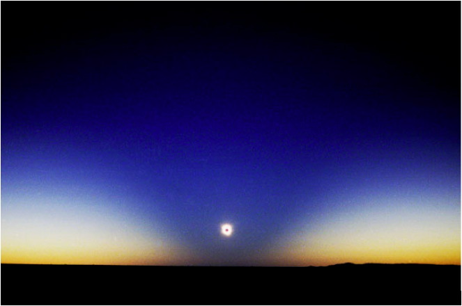
Figure
3. “God’s bowling alley” (TSE 2002 December 04 UTC) as photographed by Carter Roberts at sea level
from Lyndhurst, South Australia.
The eclipsed Sun is 4° above the at-sea-level-coincident astronomical and terrestrial horizons.
For our EFLIGHT 2021–SUNRISE the totally eclipsed Sun will be ON the astronomical horizon, but with the apparent (terrestrial) horizon depressed by 3.5°.
The eclipsed Sun is 4° above the at-sea-level-coincident astronomical and terrestrial horizons.
For our EFLIGHT 2021–SUNRISE the totally eclipsed Sun will be ON the astronomical horizon, but with the apparent (terrestrial) horizon depressed by 3.5°.
While the “big show”, of course, is totality, the proximity of Punta Arenas to the sunrise line at umbral touchdown on the Earth provides a unique opportunity to observe TSE 2021 totality with the rapidly decelerating shadow cone grazing tangentially along the surface of the Earth (e.g., see Figure 3 with a similar geometry at mid-eclipse). From our lofty EFLIGHT venue our SUNRISE aircraft will provide some of the most esthetically stunning views of the opening terrestrial traverse of the lunar umbra.
Our “Totality Run” (TR) approach to the MEI (where at MEI itself the center of the lunar umbra first and fully obliquely touches down on the Earth at 39,000 ft AMSL) begins 25.2 minutes prior to mid-total eclipse. At that “TR Start” time (06:37:02 UTC) the lower limb of the Sun in partial eclipse will touch and then rise over the -3.5° depressed terrestrial horizon (see Figure 4). The increasingly partially-eclipsed Sun then ascends toward totality with a diminishing solar photospheric crescent fully obscured by the Moon at the end of the C2 diamond ring at 07:01:23, heralding the start of 1m 45s of totality.
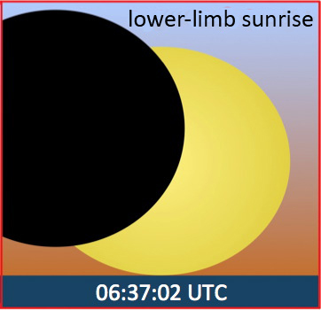
Figure 4. Schematic depiction of Sun
rising during partial eclipse
ingress from 39,000 ft. as seen from EFLIGHT
2021–SUNRISE with the Sun’s lower limb
on the terrestrial horizon at
the start
of the Totality Run.
Though only the “opening act” preceding totality, this proximal MEI location to Punta Arenas and within the MPN ETOPS60 circle permits us to program an approach for the SUNRISE totality run track that will initially present a 47% partially eclipsed Sun at lower-limb sunrise. The partially-eclipsed sunrise also marking the start of our “totality run”, like totality itself, will be visible from the left side of the aircraft*. (*Due to the low elevation angle of the eclipse, from a few seat rows flanking the third emergency exit door the aircraft wing itself will block this view, and the view of totality as well. Thus, these few specific rows will not be used for eclipse viewing.)
At this extreme line-of-sight sunrise viewing geometry, as the Sun ascends the apparent horizon, its partially-lunar-occluded disk may take on an oblate or even more extreme morphologically distorted shape due to differential atmospheric refraction with the possibility of a partially-eclipsed omega effect, or even more extreme distortions and/or a green flash while rising in partial-eclipse.
At our 07:02:14 MEI, thanks to the aircraft’s 39,000 ft altitude, the totally eclipsed Sun will gloriously stand 3.5°, i.e., 14 solar radii, above the depressed terrestrial horizon and “straight out” the left-side passenger windows. There, the umbral axis will lie in the horizontal plane parallel to surface of the Earth with the Moon’s conical shadow stretched out and over the astronomical horizon as seen in perspective sweeping over a distance of nearly 400 km, framing the Sun’s glorious corona as it circumscribes and enshrouds the ashen lunar disk for a glorious 1m 45s of totality.
This will be a TSE viewing flight of an entirely different flavor!
CENTERLINE and Mid-Eclipse-Intercept (MEI)
The total phase of TSE 2021 is optimally viewed from along the “centerline” of the PoT midway between the northern and southern path limits. The very center of the Moon’s shadow, which traces out the centerline of the PoT, is where (for any location along the path) the totality duration is longest, the sky is darkest (amazingly so at 39,000 ft*), and the view of totality is optimal. (*Our high-level eclipse-viewing altitude of 39,000 ft. AMSL that is above ~ 80% of the Earth’s atmosphere will put us into the tropopause, where the concerns of sub-polar weather (and clouds) will remain in the troposphere below.) Our EFLIGHT is designed to be precisely on centerline just as the Moon’s shadow axis reaches that centrally-located position of the aircraft, i.e., this is the UTC time-correlated point of “Mid-Eclipse Intercept” (MEI) around which the rest of the flight is planned.
The centerline of the path of totality, for all practical purposes, may be expressed as a (UTC) time-correlated set of waypoints (latitude, longitude) that maps out the central position of the Moon’s umbral shadow as it traverses the Earth. In principle, totality may be seen (where accessible and not cloudy on the ground) anywhere along that path. The TSE 2021 eclipse geometry and local circumstances guide us in selecting our MEI locations in concert and in conformance with normal aircraft performance characteristics and ETOPS60 operational limitations – and (most importantly!) above otherwise potentially problematic sub-polar cloudy weather.
BASELINE
End-to-End Plan
Routing: The EFLIGHT 2021–SUNRISE flight plan can be best described as an ~ 5-1/2 hour round-trip flight to/from the same originating location, Punta Arenas, with the inclusion of an additional critically-defined appx half-hour leg called the “Totality Run” (TR). It is from there that for 1m 45s, totality centered on 07:02:14 UTC will be observed with the aircraft at 39,000 ft AMSL concentrically located along the axis of the Moon’s umbral cone at the instant of mid-eclipse. The turn onto the totality run is immediately preceded by a contingency, real-time tunable, “circle and hold” (C&H) segment for UTC ground-track synchronization of the start of the TR in the event of a delayed take-off from Punta Arenas. The end-to-end basically “triangular” EFLIGHT plans PUQ→eclipse→PUQ can then be described as:
- take-off (“wheels-up” not push-back)
- airport pattern departure and ascent to top-of-cruise (TOC)
- outbound cruise to totality run first waypoint (TRSTART location)
- contingency circle and hold for up to 45 minutes for UTC synchronization
- release onto totality run at
UTC-correlated TRSTART waypoint (lower-limb sunrise at TRSTART)
- totality run (inclusive of, and
anchored on, the UTC-correlated MEI point)
- inbound return to start-of-descent (SOD)
- descent and pattern approach
- landing
Aircraft: We have proceeded with our baseline planning for our chartered Airbus A321-200, ETOPS60 rated aircraft, as we are discussing and maturing its flight plan and operational details with our aircraft provider/operator, LATAM Airlines. We predicate our baseline plans for a true air speed (TAS) of 447 kts (Mach 0.78) for the Totality Run in particular, also assumed as cruise speed for other pre- and post-requisite flight segments in straight-and-level flight.
Flight Duration (with 45-minute in-air contingency margin): For baseline plan definition and tolerance with in-segment flight-time variation for actual winds-aloft we assume no winds, but provide margins in the end-to-end plan to compensate for actual winds aloft in flight. With these baseline assumptions we estimate the end-to-end duration as closely proximate to < 5.4 hour. Preliminary ETD 3:24 UTC ex-Punta Arenas (to be updated/confirmed).
BASELINE Totality Run
Predicated by the MEI UTC and location for EFLIGHT 2021–SUNRISE flight, the end-to-end baseline totality run may be represented in simple parametric form with three key time-correlated waypoints defined by their start, MEI, and end. We enter the TR run track 25.2 minutes prior to MEI (allowing for pre-totality sunrise viewing). The TR ends 6 minutes after MEI.
| Totality Run Waypoint |
UTC (hh:mm:ss) |
Aircraft Longitude |
Aircraft Latitude |
| TRSTART |
06:37:02 |
W04806.112 |
S5006.932 |
| MEI |
07:02:14 | W05110.202 |
S5234.421 |
| TREND |
07:08:14 |
W05157.054 |
S5308.783 |
(all coordinates WGS84 referential datum)
CLICK HERE for a multi-parametric tabulation of this Totality Run with 1 minute time granularity w.r.t. MEI after ETOPS60-limited TRSTART (START).
CLICK HERE for an explanation of the multi-parametric tabulation.
TIMING CONTINGENCIES
(pre-planning for success)
The PUQ→eclipse→PUQ EFLIGHT plan is designed with more than sufficient time to execute all fight segments. In the unlikely event of a take-off delay, or with unfavorable outbound winds, our pre-planned, expendable, C&H leg provides an additional in-flight margin of up to 45 minutes for the successful attainment of the MEI exactly as planned. Beyond this margin, we have further contingency flexibility to modify the TR if necessary, maintaining the same MEI by shortening the length of its pre-C2 TR segment by up to approximately 20 additional minutes.
COMPARATIVE
RISK ASSESSMENT - TSE 2021
Ground-based (including sea-going) TSE observations are inherently “risky” due to the ever-present possibility of uncooperative weather. This is the case, in particular, from sky cover obscuration due to clouds, fog, or precipitation that differ from eclipse to eclipse and with location. E.g., for statistical expectations and discussion specifically germane for TSE 2021 see HERE. Therein the risk of cloud cover obscuring totality for locations reachable by ship is summarized by eclipse-weather expert Jay Anderson as “Over the oceans, cloud cover averages more than 90% {!}”
When path access is limited (as extremely so for TSE 2021) but not impossible, and nature conspires against us with high risk of obscuring clouds, some will nonetheless (grudgingly) accept such risks when no other alternatives are presented.
Such high-risk scenarios, however, are eliminated by employing a high-altitude jet aircraft as a platform for eclipse observations. Risk is never entirely mitigated, but typically can be reduced to at most a few percent. E.g., while the statistical expectation of opaque cloud above 39,000 ft is vanishingly small for a sub-polar eclipse such as TSE 2021 where we plan to intercept, it is non-zero due to other remote possibilities. E.g., one could posit various, but highly unlikely, reasons the point-of-departure airport could shut down due to low-probability events, but the percentage “chance” of that occurring at requisite take-off time is counted generously on fingers far less than on one hand.
In the case of our EFLIGHT 2021–SUNRISE scenario, the risk of not seeing totality is somewhat “high” by airplane expectations (but extremely low compared to anything else!). That risk is about 4%, and potential flight participants must understand (and accept) this risk.
This risk comes about from the necessity to plan a requisite contingency ETOPS60 diversion landing return specifically at the Royal Air Force (UK) Mt. Pleasant airport (MPN) in the Falkland (Malvinas) Islands. MPN is the only existing facility for such planning that allows us to boot-strap with an ETOPS60 hop to the path of totality (see Figure 2). During the months of November and December (climatologically representative of the December 4 eclipse time of year), approximately 4%* of the time, MPN experiences a high-wind phenomenon known as “rotor winds” – severe low-level turbulence causing a temporary closing of the runway until subsidence. (*Based on prior year NOTAMS (Notice to Airmen) statistics; e.g., in 2018 MPN was closed to air traffic for a total of 61 hours out of 1464.) While we do not plan at all to land at MPN, it must be available (open) to us while we are in the air. Thus, if the MPN runway closes for this reason (or is forecast/predicted to close) during that time, we would not be permitted to take off from PUQ. To put in perspective in comparison to the “next best” option by ship, the statistical expectation of the likelihood of success by deploying into a cloud-free sky with EFLIGHT 2021–SUNRISE is ~ 96%, whereas the “odds" of successfully viewing the eclipse on the ocean are < 10% (per quoted reference from J. Anderson, above).
WINDOW-SHARING
and ECLIPSE-VIEWING
Probably the most often asked questions related to the aircraft windows for eclipse viewing are:
- “What are the aircraft windows like?”
- “Could I share a window in an eclipse-viewing seat row with a partner to watch the eclipse?”
- “Can’t aircraft windows fog or frost up?”
1a) QUALITY: Commercial aircraft windows are not research-grade optics. Nonetheless, if not optically degraded in some fashion, such windows are typically more than well suited for visual and/or binocular viewing of TSEs, and for wide- to intermediate-field photographic imaging and even low-resolution spectroscopy. Several examples are offered below. This, of course, depends upon the window quality. Part of our charter contract requirements to our aircraft provider/operator specifies the need and protocol to importantly secure the best (and thus often typically newest) aircraft in their fleet from the perspective of defect-free, distortion-free, and scratch/sleek-free windows as a key factor in aircraft down-selection. Aircraft with more than a minimal number of such window artifacts will be rejected from our consideration. Window cleanliness (free of dust, dirt, oils, or any other light-scattering materials or particulates), of course, is also essential; and well-proven protocols for pre-EFLIGHT window cleaning (without leaving residual streaks) are called out in a technical annex to our charter requirements.
Though no photographs can come close to reproducing the magnificent views captured on our retinas and interpreted by our visual cortices, here are a few images taken on prior EFLIGHTs through their aircraft windows indicative of their suitability for TSE observing.
Wide-Field
Imaging: View from EFLIGHT
2015 March 20 UTC over the Norwegian Sea at Second
Contact, 35,000 ft.
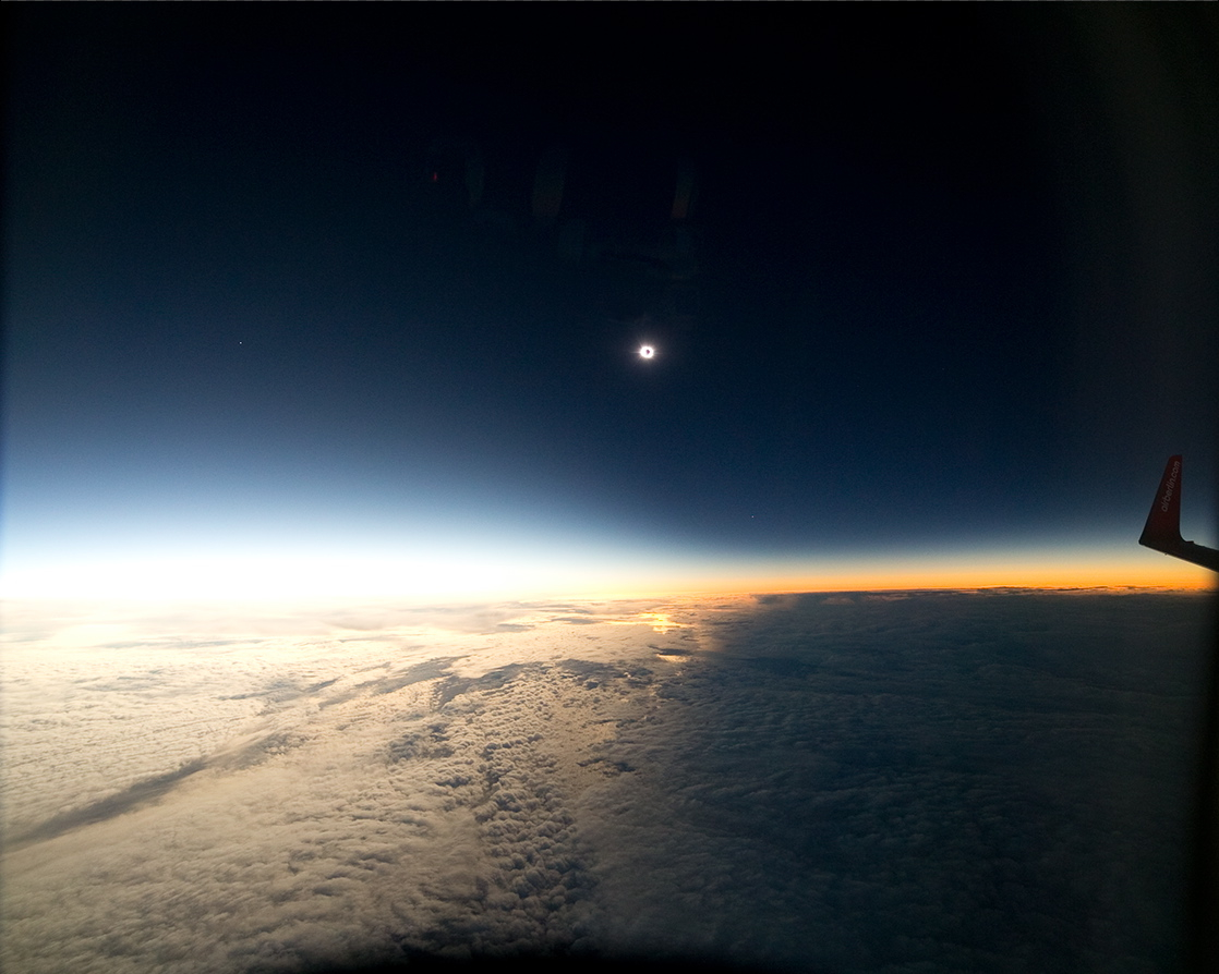
Canon EOS 5D
Mark III Digital SLR at ISO 1600, 1/60th sec, 14mm EFL f/2.8 Rokinon IF
ED UMC Ultra Wide-Angle Lens used at f/4
Glenn Schneider and Geoff Simms
Glenn Schneider and Geoff Simms
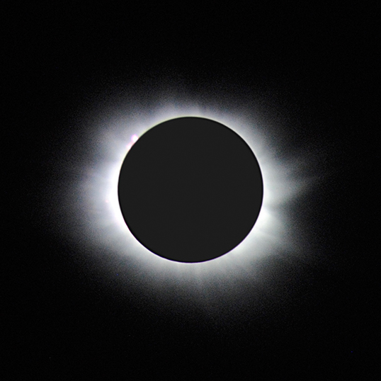
Coronal
Imaging from EFLIGHT 2015
over the Norwegian Sea, 35,000 ft.
| Inner Corona |
Mid+Outer
Corona |
 |
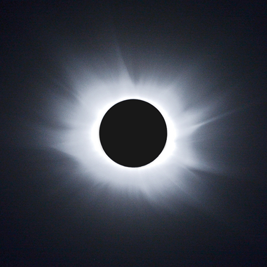 |
Nikon D3000
+ 300 mm f/5.6 VR lens (ISO 800) – handheld. Left: single frame, right:
5 frame stepped exposure time composite
Glenn Schneider
Click HERE for some remarkable HDR coronal imaging from EFLIGHT 2003 November 24-23 UTC by Miloslav Druckmüller and David Finlay – Antarctica, 35,000 ft.
Glenn Schneider
Click HERE for some remarkable HDR coronal imaging from EFLIGHT 2003 November 24-23 UTC by Miloslav Druckmüller and David Finlay – Antarctica, 35,000 ft.
Totality Time-Resolved Coronal
Ramp
Up/Down Imaging from EFLIGHT
2010 July 11 UTC – South Pacific, 39,000 ft.
Nikon DX3
camera at ISO 200 and VR 80-400 mm lens at 400 mm f/5.6. (Double-click
on the image mosaic to view at larger scale.)
Glenn Schneider
Glenn Schneider
Near-Infrared (0.7 to 1.0 micron)
Chromospheric “Flash” Spectrum at C2 from EFLIGHT 2019–MAX (July 2) –
1,100
km N. of Easter Island, 41,000 ft.

“ICARUS”
near-IR grating spectrograph with Canon EOS 500D camera ISO
200 –
IR
extended and Peltier cooled, 3.2s exposure.
Glenn Schneider and Aris Voulgaris
Glenn Schneider and Aris Voulgaris
1b) METROLOGY. Below is an annotated photograph that shows the Airbus A320-family window metrology. This particular photo was actually taken from our EFLIGHT 2010 aircraft, which was an Airbus A319/LR-CRJ. The window metrology and spacing, however, is identical to the A321-200 we will use for EFLIGHT 2021–SUNRISE (except where exit row doors interrupt the otherwise uniform spacing of the windows).
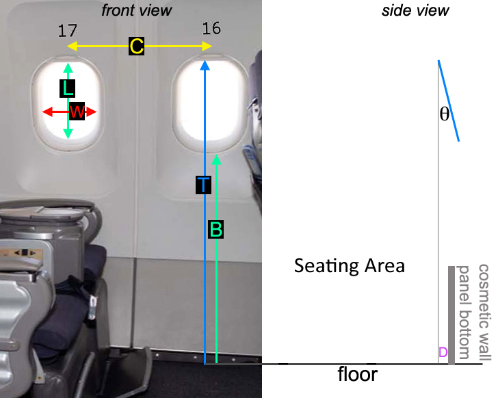
C = 53 cm Inter-window centerline distance
(most windows; a few have larger inter-window spacings)
L = 30 cm Clear-area with trim gasket window-length
W = 21 cm Clear-area with trim gasket window-width
T = 114 cm Top of window to floor vertical distance
B = 86 cm Bottom of window (actual surface, not trim) to floor vertical distance
D = 0 cm Top of window protrusion distance vertical to cabin floor edge [a]
θ = 14 deg Tilt angle (top inward) of window with respect to vertical [b]
[a] The right panel figure indicates a downward projection of the window top onto the floor is inboard (by a distance D) of bottom of the actually slightly curved wall.
This is typically actually zero, but the cosmetic wall floor panel may be different in our charter aircraft [TBD].
[b] The windows themselves, as mounted on the aircraft fuselage, are tilted inward at the top by appx 14°.
2) WINDOW
SHARING. The low
vertical angle of the Sun (on the horizontal plane, 3.5° above the
terrestrial horizon at 39,000 ft) will greatly facilitate “window
sharing” for those contemplating an observing partner, which can be
much more problematic (and contorting!) for high-solar-elevation-angle
eclipse flights. To aid in visualization, we have a high-fidelity
window template
from Airbus that, if you print to actual size, you can tape to a
wall following the dimensions above and try for yourself. Click HERE
for that template. So the
answer to this second question is – yes. However, what we
do not know yet is the relative positioning of the seats
in individual rows with respect to windows in those rows. So, some
rows will have access to one,
or fractionally more than one, window that will be more easily
shared in some rows than others. We will have detailed
information on this on a row-by-row basis at a later date to inform
flight participants on the best rows suited to their individual needs.
3) WINDOW CONDENSATION/FROSTING: FULLY EFFECTIVE MITIGATION. In a nutshell...
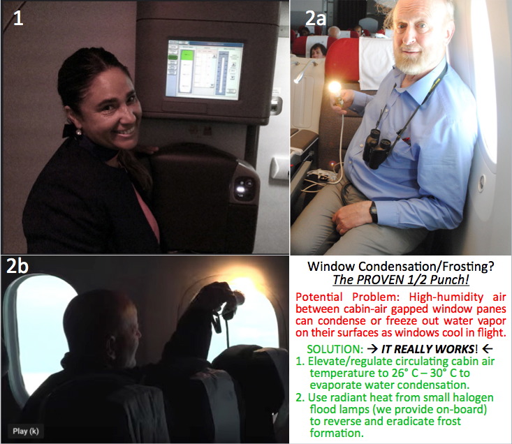
1. Click image for close-up of cabin air temperature control
2. Click HERE to see one of the lamps most recently used very effectively on EFLIGHT 2019-MAX
3) WINDOW CONDENSATION/FROSTING: FULLY EFFECTIVE MITIGATION. In a nutshell...

1. Click image for close-up of cabin air temperature control
2. Click HERE to see one of the lamps most recently used very effectively on EFLIGHT 2019-MAX
