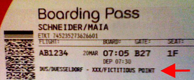
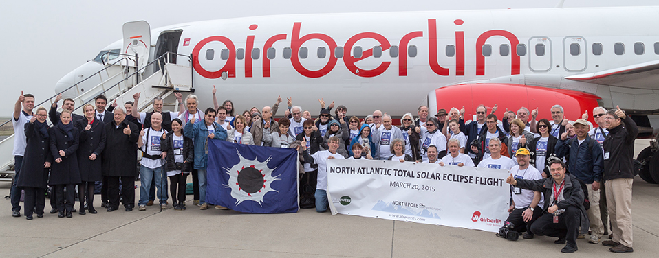
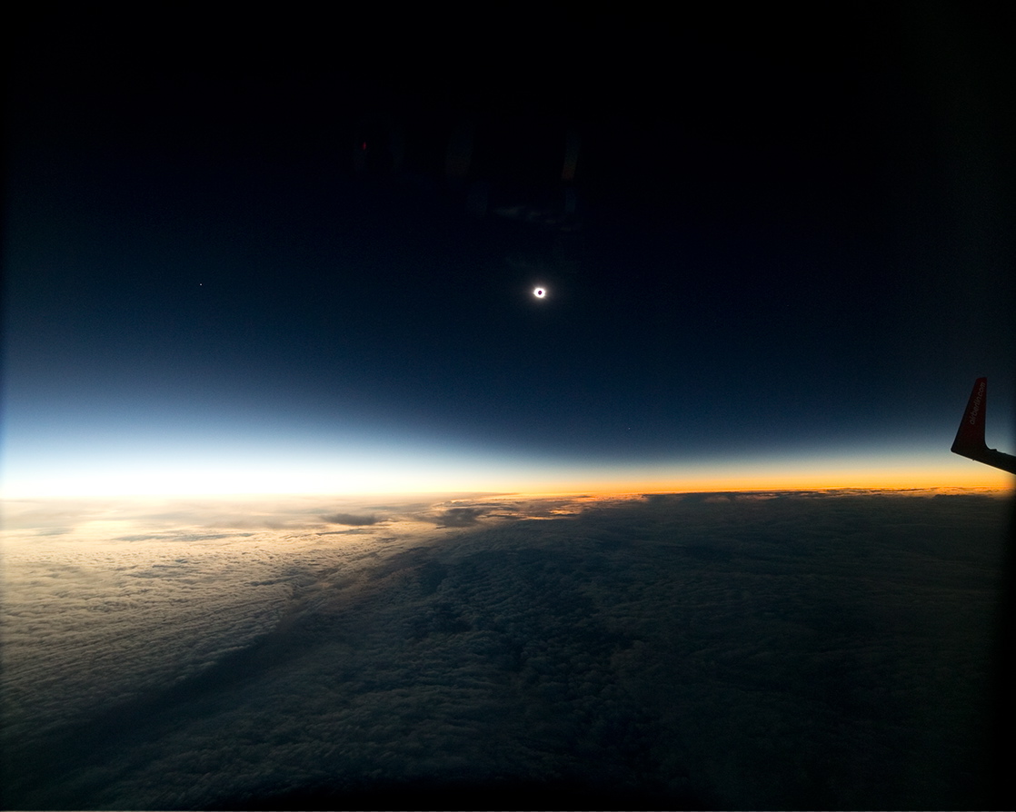
TOTAL SOLAR ECLIPSE 20 MARCH 2015
Glenn Schneider, Steward Observatory, The University of Arizona
3m 39s of Totality from 35,000 ft. AMSL
Mid-Eclipse @ 09:43:30 UTC, Latitude = 63° 13' 08.0"N, Longitude = 07° 53' 05.6"W
See HERE for background (pre-flight) information on "EFLIGHT 2015"
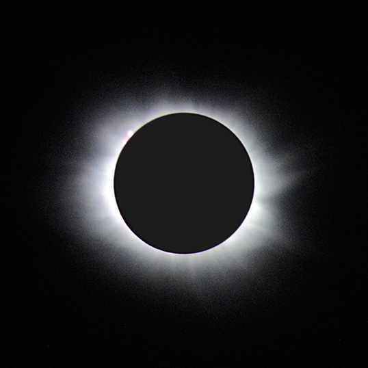
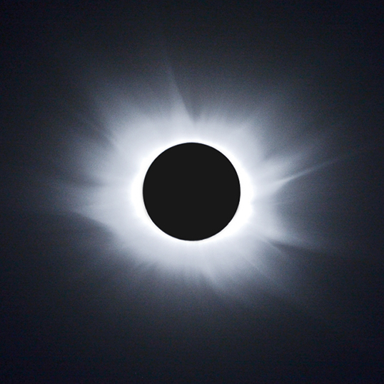
Coronal Imaging
| Inner Corona |
Mid+Outer
Corona |
 |
 |
C3 Diamond Ring (with a twist...)
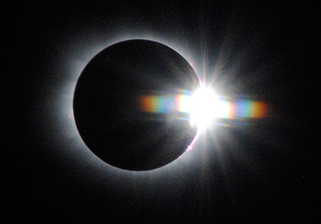 |
thanks to the optical properties of the multi-layer aircraft windows.
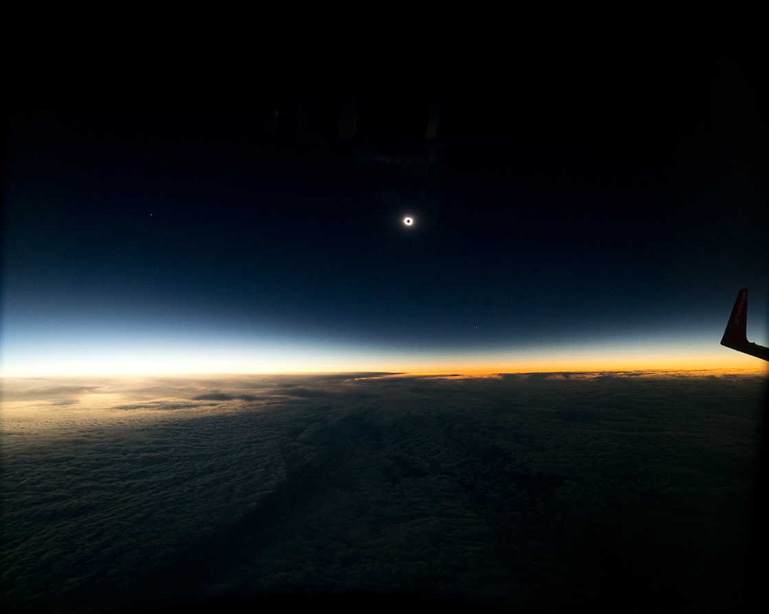
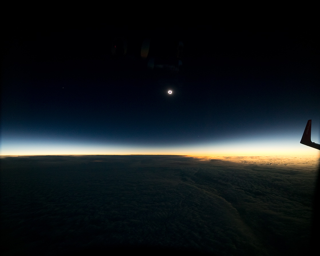
Time Resolved Wide-Field Umbral Imaging
In collaboration with Geoff Sims, The University of New South Wales
Umbral Immersion C2 (top left) to C3 (bottom right)
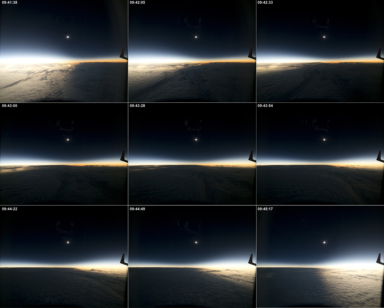
Nine of 1776 frames at ~ 2 fps to be assembled into a time-lapse movie (stay tuned...).
Camera: Canon EOS 5D Mark III Digital SLR at ISO 1600, 1/60th sec
Lens: 14mm EFL f/2.8 Rokinon IF ED UMC Ultra Wide-Angle Lens used at f/4
Intervelometer: Aputure AP-TR3C at 1.998 frames per second (measured)
Click below on UTC timetag for a higher-resolution rendering of selected frames:
| 09:41:38 |
09:42:05 |
09:42:33 |
| 09:43:00 |
09:43:28 |
09:43:54 |
| 09:44:22 |
09:44:49 |
09:45:17 |
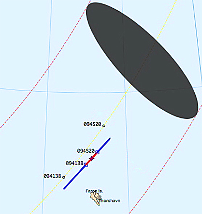
Spot-On: Or VERY Nearly, so! (and the Isavia Story)
On Friday, March
13, due to the heavy volume of air traffic in the immediate area of
interest for the eclipse (est. 15 eclipse flights plus crossing
trans-Atlantic traffic), Isavia (Icelandic Air Traffic
Control) issued a directive
restricting eclipse flight operations only along two specific
"tracks" designated "Eclipse East" and "Eclipse West". The names
reflect Isavia's intention to develop two specific corridors flanking
(and roughly but not exactly parallel to) and equi-spaced by about 8 NM
on either side of centerline. Our flight (AB B737-800/DUS; later
designated AB 1234) was an assigned a flight level of 35,000 ft (FL
350) on the East track, the other two Air Berlin flights (AB
A320-200/DUS and AB A320-200/ZHR) were respectively assigned FL350 and
FL340 on "Eclipse West". At that point I was asked to develop
revised Totality Run scenarios for all three AB flights for delivery to
(and approval by) Isavia by way of AirEvents and Air Berlin.
The Isavia"tracks" were defined by way points of their creation provided in the directive to be used with "no deviation". The way points, however were quantified in units of 15 minutes of arc (!) in Lat/Lon, so could not (and did not) exactly "parallel" centerline, and in fact had inflections (course changes!) at the way point track vertices. Moreover, to ascertain the location of centerline in defining the "east"/"west" approximations for the two-tracks, Isavia consulted the NASA (Fred Espenak's) eclipse web site -- apparently not realizing the information provided there in was for sea level only! As a result the "east" track was shifted by about 15.5 NM from centerline (at 09:43:30 UTC), while the "West" track was actually very close to centerline, for aircrafts operating at ~ 35,000 ft. As a result, with replanning summarized below, the two AB A320 flights on the "west" track ended up very close to at-altitude centerline.
Click HERE for the FINAL (approved) revision for the three AB flight totality runs, defined simply by three waypoints conforming to the Isavia restrictions. For "simplicity", and confined between Isavia waypoints, in iterated replanning I had put all three AB totality runs with mid-eclipse intercepts at 09:43:30 UTC, with the two A320's on the "west" track altitude stacked by 1,000 ft (so AOK for the same time-correlated UTC for mid-eclipse).
Note that the predicted duration(s) of totality I had given in the above linked summary document were for a no-wind condition only used for planning purposes. With actual winds aloft, to maintain the requisite time-correlated ground-track, the aircraft ground speed (and thus duration of totality) would be different. The "no wind" prediction (with lunar-limb profile corrections, of course) for "AB 1234" (the AB B737/DUS) flight was 03m 42.7s on the "east" track, and 03m 45.7s for the two A320 flights on the "west" track.
Re-planned Totality Run for AB/B737-800 DUS (AB 1234)
From a frame-by-frame examination of the original (15 Mby) images, the duration of totality as measured from the complete extinction of all photospheric Baily's Beads was 03m 39s ± 0.5 s. In (additional) detail (as provided to our pilots), an intermediate time-correlated way points for C2 was hit nearly dead on (1/2 second late), but C3 was hit appx 3-1/2 seconds "early". The difference? WIND (as expected).
Here is the rest of the story... Just as we were completing our totality run and staring our turn back to Dusseldorf, I went back onto the flight deck to get a winds aloft reading from the aircraft FMS (flight management system) display. You can see that as 46 knots from 341 degrees true (top left of the right hand display). This was just about 6 minutes after mid eclipse, and the winds MAY have had some variability during the totality run, but this is a first-order approximation much better than the a prior simplistic "no wind" condition.
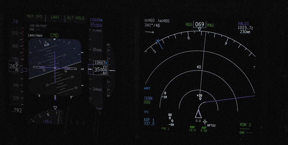
With that wind vector, below is a re-computation of our (B737-800) totality run, with 1 minute time granulatity:
UTC Intercept: 09:43:30.3 | Duration of Totality: 3m 39.1s (limb profile corrections applied)
Flight Level: 35000ft | Apparent Horizon Depression: -3.3° w.r.t. astronomical
Course at mid-ecl: 42.59d | Cnt hh:mm:ss.s Alt-d Azm-d P-d Cnt hh:mm:ss.s Alt-d Azm-d P-d
True Air Speed: 447.4kt | 2nd 09:41:39.3 +18.8 132.8 75.1 3rd 09:45:18.4 +19.2 134.5 240.9
Wind Speed: 46.0kt | Latitude: 63° 04' 24.8" N Latitude: 63° 21' 48.0" N
Wind Direction: 341.0d | Longitude: 007° 30' 38.6" W Longitude: 006° 47' 48.6" W
====================================================================================================================
________Center of the Umbral Shadow__________ ____________________________Aircraft________________________
UTC Longitude Latitude Width Speed Azm Alt Longitude Latitude Mid-dT Mid-dD LOS Brng Azim Alt
HHMMSS deg deg km km/h deg deg deg deg sec NM deg deg deg deg
093430 -13.65115 +60.16720 474.2 3281.4 124.3 17.7 -8.86545 +62.49702 -540 -64.1 +3.0 46.50 129.5 18.1 P
093530 -12.94773 +60.50988 472.8 3256.2 125.3 17.9 -8.67958 +62.57825 -480 -57.0 +2.6 46.66 130.0 18.2 P
093630 -12.25438 +60.85634 471.4 3235.8 126.3 18.0 -8.49269 +62.65922 -420 -49.9 +2.1 46.83 130.4 18.3 P
093730 -11.56990 +61.20674 469.8 3219.9 127.3 18.2 -8.30478 +62.73995 -360 -42.7 +1.7 47.00 130.9 18.4 P
093830 -10.89314 +61.56120 468.2 3208.2 128.3 18.3 -8.11585 +62.82042 -300 -35.6 +1.2 47.17 131.4 18.5 P
093930 -10.22301 +61.91989 466.4 3200.5 129.3 18.4 -7.92588 +62.90063 -240 -28.5 +0.8 47.33 131.8 18.6 P
094030 -9.55851 +62.28295 464.7 3196.6 130.3 18.5 -7.73487 +62.98059 -180 -21.4 +0.3 47.51 132.3 18.7 P
094130 -8.89865 +62.65057 462.8 3196.2 131.3 18.6 -7.54282 +63.06029 -120 -14.2 -0.1 47.68 132.7 18.8 P
094230 -8.24250 +63.02293 460.9 3199.3 132.3 18.7 -7.34972 +63.13972 -60 -7.1 -0.6 47.85 133.2 18.9 T
094330 -7.58913 +63.40023 459.0 3205.7 133.3 18.7 -7.15556 +63.21889 -0 -0.0 -1.1 48.02 133.6 19.0 T
094430 -6.93765 +63.78267 457.1 3215.5 134.3 18.7 -6.96033 +63.29779 +60 +7.1 -1.5 48.20 134.1 19.1 T
094530 -6.28717 +64.17049 455.1 3228.5 135.3 18.7 -6.76404 +63.37642 +120 +14.2 -2.0 48.37 134.6 19.2 P
094630 -5.63681 +64.56393 453.1 3244.7 136.3 18.7 -6.56667 +63.45478 +180 +21.4 -2.5 48.55 135.0 19.3 P
094730 -4.98566 +64.96325 451.1 3264.2 137.3 18.7 -6.36823 +63.53287 +240 +28.5 -2.9 48.73 135.5 19.3 P
094830 -4.33282 +65.36875 449.1 3287.0 138.3 18.7 -6.16870 +63.61067 +300 +35.6 -3.4 48.90 136.0 19.4 P
094930 -3.67736 +65.78074 447.1 3313.1 139.3 18.6 -5.96807 +63.68820 +360 +42.7 -3.9 49.08 136.5 19.5 P
(see HERE for explanitory notes.)
Note the duration of totality: 3m 39s --
as measured by complete photospheric extinction with frames from the
2 fps imaging camera. I do not know the wind vector for the two
AB
A320 aircraft, so I cannot compute the exact circumstances for those
aircraft. However, as they were "only" ~ 30 NM away, and at the
same/similar altitude, it is likely the winds were similar during the
totality run, and hence one may expect a very similar reduction of ~ 4
sec in their duration of totality.
And... as known, we were not alone. Here (below) a visualization of the "crowded" skies from flightradar24.com. Looks like, somehow, one aircraft (FYG = Flying Group, Belgium) ended up between the Isavia East and West tracks. Further, it seems that two regularly scheduled Turkish Airlines (THY) flights from Chicago and Toronto to Istanbul were serendipitously at the right time and place. From their headings as depicted, it seems the pilots may have gotten a great view of totality. However, it looks like the angle to the Sun too oblique for the starboard side passengers to have gotten a view of totality.

-------------------------
Last update: 27 March 2015
RETURN to Glenn Schneider's Umbraphillia Page
And... as known, we were not alone. Here (below) a visualization of the "crowded" skies from flightradar24.com. Looks like, somehow, one aircraft (FYG = Flying Group, Belgium) ended up between the Isavia East and West tracks. Further, it seems that two regularly scheduled Turkish Airlines (THY) flights from Chicago and Toronto to Istanbul were serendipitously at the right time and place. From their headings as depicted, it seems the pilots may have gotten a great view of totality. However, it looks like the angle to the Sun too oblique for the starboard side passengers to have gotten a view of totality.
-------------------------
Last update: 27 March 2015
RETURN to Glenn Schneider's Umbraphillia Page