EFLIGHT 2015 – 20 March 2015 Total
Solar
Eclipse
An Amazing Flight into The Darkness of the Lunar Umbral Shadow
From the Pristine, Dark, Cloud-Free Free Skies > 37,000 feet AMSL
Dr. Glenn Schneider
Astronomer and EXCEDE Project Principal Investigator
Steward Observatory and the Department of Astronomy
933 North Cherry Avenue
The University of Arizona
Tucson, Arizona 85721 USA
Telephone: 520-621-5865
email: gschneider@as.arizona,edu
URL: http://nicmosis.as.arizona.edu:8000
~ 3m 45s ± ~ 10s of prolonged Greatest-Eclipse Totality @ 63.4° N Latitude
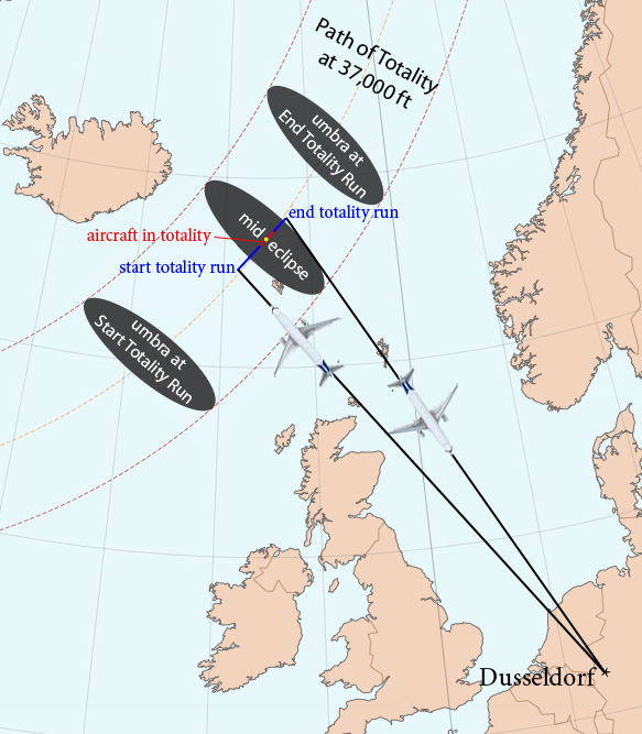
Launched from Dusseldorf, Germany to the point of "Maximum Eclipse"
A COLLABORATIVE ADVENTURE OFFERED BY:
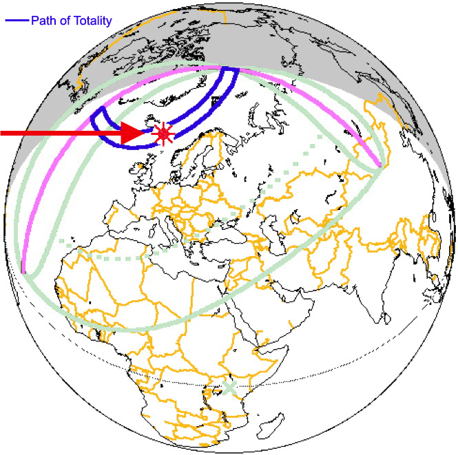
THE TSE
2015 PATH OF TOTALITY
The TSE
2015 path of totality (left: blue arc, right: gray arc) with our
planned point of "to the max" mid-eclipse intercept indicated (red
markers).
(Maps: left - adapted from Espenak and Meeus 2006, 5MCSE; right - adapted from HMNO)
An Amazing Flight into The Darkness of the Lunar Umbral Shadow
From the Pristine, Dark, Cloud-Free Free Skies > 37,000 feet AMSL
Dr. Glenn Schneider
Astronomer and EXCEDE Project Principal Investigator
Steward Observatory and the Department of Astronomy
933 North Cherry Avenue
The University of Arizona
Tucson, Arizona 85721 USA
Telephone: 520-621-5865
email: gschneider@as.arizona,edu
URL: http://nicmosis.as.arizona.edu:8000
~ 3m 45s ± ~ 10s of prolonged Greatest-Eclipse Totality @ 63.4° N Latitude
 |
 |
Launched from Dusseldorf, Germany to the point of "Maximum Eclipse"
A COLLABORATIVE ADVENTURE OFFERED BY:
| Dr.
Glenn Schneider (Steward Observatory, University of Arizona) Eclipse Flight Technical Planning/Implementation |
Airberlin
Airlines Aircraft Provider Aircraft Operator |
Deutsche
Polarflug / AirEvents, Ltd. Air Charter Flight Logistical Arrangements |
TravelQuest
International --> CONTACT for <-- Flight Bookings |
TOP 10 REASONS FOR A HIGH LATITUDE
STRATOSPHERIC
TSE 2015 ECLIPSE FLIGHT
| DEPLOYMENT/RELOCATION FLEXIBILITY To Find the BEST Spot(s) in the Area of Operations for Observing |
CLOUD OBSCURATION AVOIDANCE High Latitude Stratosphere Stratosphere: 99.99% -- Virtually Assured |
| TOTALITY PROLONGATION FOR MAXIMUM ECLIPSE Aircraft Speed Extends the Duration of Totality |
SKY TRANSPARENCY Significantly Improved -- Low Particulate Scattering |
| SKY DARKNESS Much Higher Contrast Coronal Visibility and to Larger Circumsolar Distance |
IMPROVED ASTRONOMICAL SEEING "r_naugh" Decreases with Increasing Altitude |
| REDUCED ATMOSPHERIC TURBIDITY Vorticity & Sheer Decline in Power Above Tropopause |
PANCHROMATIC
VISIBILITY IR and UV "Windows" Open Up or are Extended |
| UNPARALLELED HORIZON REACH &
OBSERVATION VISTA Apparent horizon 377 km distant, depressed 3.4° (at 37,000 ft) |
ESTHETIC, ETHEREAL EXPERIENCE There is nothing quite like it... |
A truly remarkable, but
geographically remote, total solar eclipse
(TSE) will occur on 20 March 2015 with the Sun on the
celestial equator at the vernal equinox, as
the Moon's umbral shadow traverses a narrow path for 1 hour and 5
minutes over the North Atlantic and Arctic Oceans, spectacularly ending
with a blackened sunrise at the geographic North Pole. The
path of
totality, the region on the Earth's surface where the Sun will be
totally obscured by the Moon, begins at sunrise over the cold waters of
the north Atlantic Ocean 650 km east of Newfoundland where the eclipse
centerline then at 09:13 UT is 600 km is south of the southern tip of
Greenland. The path then sweeps north eastward passing, but
missing,
the east coast of Iceland in route, literally, to the "top" of the
world at the North geographic pole.
 |
 |
(Maps: left - adapted from Espenak and Meeus 2006, 5MCSE; right - adapted from HMNO)
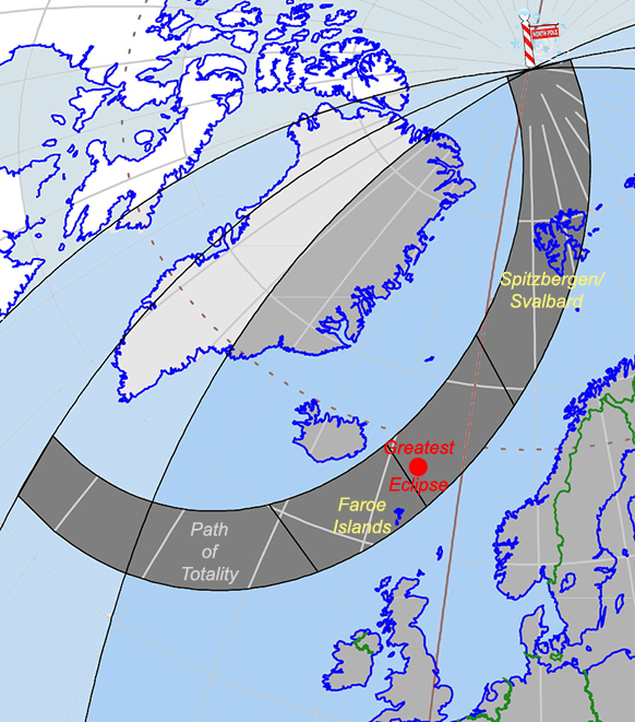
TSE 2015 finds landfall only on two north Atlantic island locations. The first, to the south-east of the centerline of the path of totality, on the Faroe Islands (latitude 62° N) where the Sun will fall into total eclipse for a maximum duration of off-centerline totality of 2m 25s on the western side of the tiny island of Mykines. The second, as the centerline of the path of totality traverses Svalbard/Spitzbergen (latitude ~ 79° N) giving rise to a nearly equal maximum on-the-ground duration of on-centerline totality 2m 26s from the island's north coast. Both island locations, while wonderful locations to visit and explore, are very likely contra-indicated as eclipse viewing sites in mid-March due to the strong prevalence of clouds and precipitation (e.g., see here and here) with high probabilities of obscuration with the Sun at low elevation angles above the local horizons. Some eclipse chasers will undoubtedly make the attempt, and we wish them great luck – but the virtually-assured solution for TSE 2015 observers is to take to the skies above the prevailing weather.
The point of greatest eclipse, 250 km north of the Faroe Islands in the Norwegian Sea between Iceland and Norway, is where the Moon's shadow is very nearly simultaneously moving most slowly across the Earth and the duration of totality is at a maximum anywhere along the path of totality (2m 47s). Further north, after passing over Svalbard/Spitzbergen, the Moon's shadow streaks northward to the geographic North Pole where at 10:17 UT with (from sea-level) the horizon bifurcating the fully-eclipsed Sun as it very slowly rises and the Pole is plunged into a prolonged total eclipse induced twilight for 1m 55s.
The ideal location on Earth for eclipse-chasers to observe TSE 2015 would be at (or very close to) at the point of greatest eclipse, if the twin, daunting, concerns of weather (high probability of cloud cover) and lack-of-accessibility (in the frigid waters off the east coast of Iceland) could be overcome. Our now-planned TSE 2015 eclipse observation flight, "EFLIGHT 2015 MAX" removes these dual obstacles, and this rare opportunity is now enabled for high-flying umbraphiles.
For TSE
2015 we have planned a spectacular airborne eclipse
expedition to simultaneously satisfy the goals and objectives of
umbraphiles called by the siren's
song of "duration, duration, duration" while obviating concerns of very
high-probability cloudy weather miles below on the Earth's
surface. EFLIGHT 2015 MAX
will stretch the duration of totality to ~ 3m 45s, with our
aircraft immersed centrally in the lunar umbra at mid-eclipse from a
sky-high venue > 11 km above the surface of the Earth. EFLIGHT
2015 MAX will launch from Dusseldorf, Germany with optimal
eclipse
viewing as the driving requirement for defining all details of the
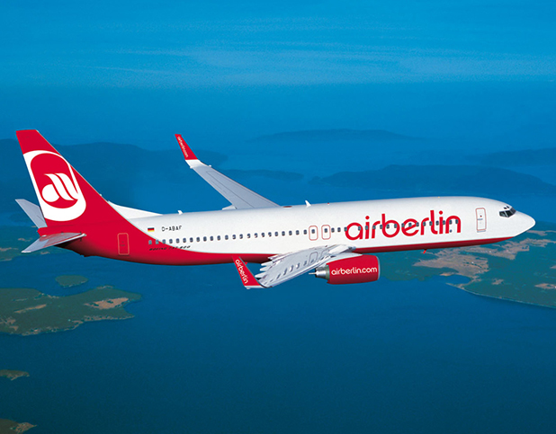
flight plan of our Air Berlin Boeing 737-800 aircraft. During
totality, the
eclipsed Sun will be
positioned "straight out" the main cabin passenger
windows for optimum viewing of the corona enshrouded Sun and umbral
shadow on the sea/ice below and eclipse-darkened sky above from an
altitude of >
37,000 ft AMSL where we will be above any
obscuring clouds and otherwise disturbing weather below.
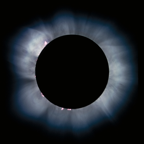
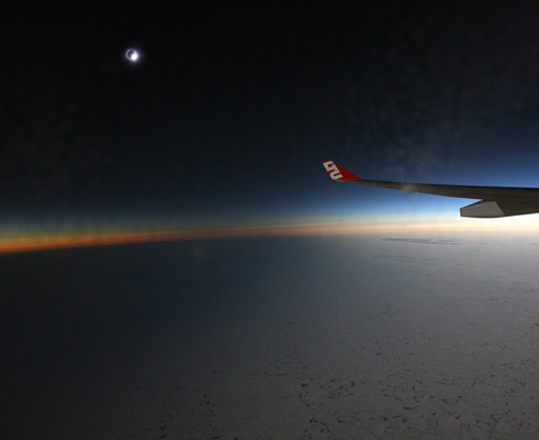
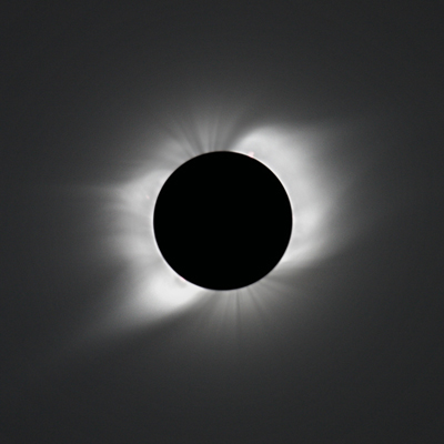
Viewing a total solar eclipse, and the sweep of the Moon's umbral shadow as it races across (and above) the Earth, as seen from such a lofty height as enabled by our EFLIGHT aircraft, is magnificent beyond description. As seen from 37,000 feet above the surface of the Earth, the apparent horizon is 377 km (234 miles) away and depressed by 3.4° compared to sea level. Looking along the apex of the lunar umbral cone toward the eclipsed Sun at mid-totality, or along its outer periphery as the shadow sweeps over the aircraft coincident with the instants of second or third contacts, the curvature and grandeur of the umbral shadow boundary (i.e., the "shadow ellipse") is stunningly apparent. See HERE for a graphic illustration of the Sky at Totality and the movement of the umbral shadow on the Earth. At near-polar latitudes in mid-March, the high reflectivity of the polar ice and/or cloud tops far below accentuates the stark contrast between the eclipse-darkened regions within umbral shadow, and those illuminated by the Sun beyond the shadow's edge. Being above more than 3/4 of the Earth's atmosphere, the corona of the Sun is presented with contrast and clarity in the rarefied air incomparable to ground-based venues at the bottom of a bubbling pool of atmospheric turbulence. See below, shadow and corona photos taken from our predecessor TSE 2008 flight; similarly executed over the Arctic Ocean.
 |
 |
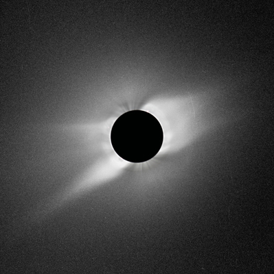 |
Stunning stratospheric views (and
photographs) of the 01
August 2008 Total Solar Eclipse, at 82° N latitude, 11
km above the Arctic Ocean, were uniquely obtained on board
our then-chartered AirBerlin (LTU) A330-200 EFLIGHT
2008 aircraft (above by Dan McGlaun, Bill Kraemer, Glenn
Schneider). In planning EFLIGHT 2015 MAX we drew
significantly in detail upon the successes of this historical
predecessor
implemented also in partnership with AirEvents/Deutsche
Polarflug under the experienced guidance and technical leadership
of Dr.
Glenn Schneider (Steward Observatory, The University of Arizona)
and in collaboration with TraveQuest
International.
EFLIGHT
2015 MAX will be aboard an Air Berlin provided and operated Boeing
737-800,
eclipse-suitable,
narrow-body jet aircraft, providing the best and most
cost-effective viewing-window to seat-count ratio, to
be used to centrally intercept the
Moon's shadow at a point within ± 1/20th second of the duration
of the greatest (globally maximum) eclipse at
(nominally) 37,000 AMSL.
With an at-altitude mid-eclipse occurring at 09h 43m 30s UTC, the duration of totality will be stretched to approximately 3m 45*s ± 10s, a minute longer than would be possible from a hypothetical Ocean-going vessel 11 km below, and appx. a minute and a half longer than will be seen from the Faroe Islands (should clouds below us cooperate for ground-based observers located there). *Duration with with no wind at Mach 0.78 (@ 37,000 ft), so a nominal ground speed of 447.4 nm/h.
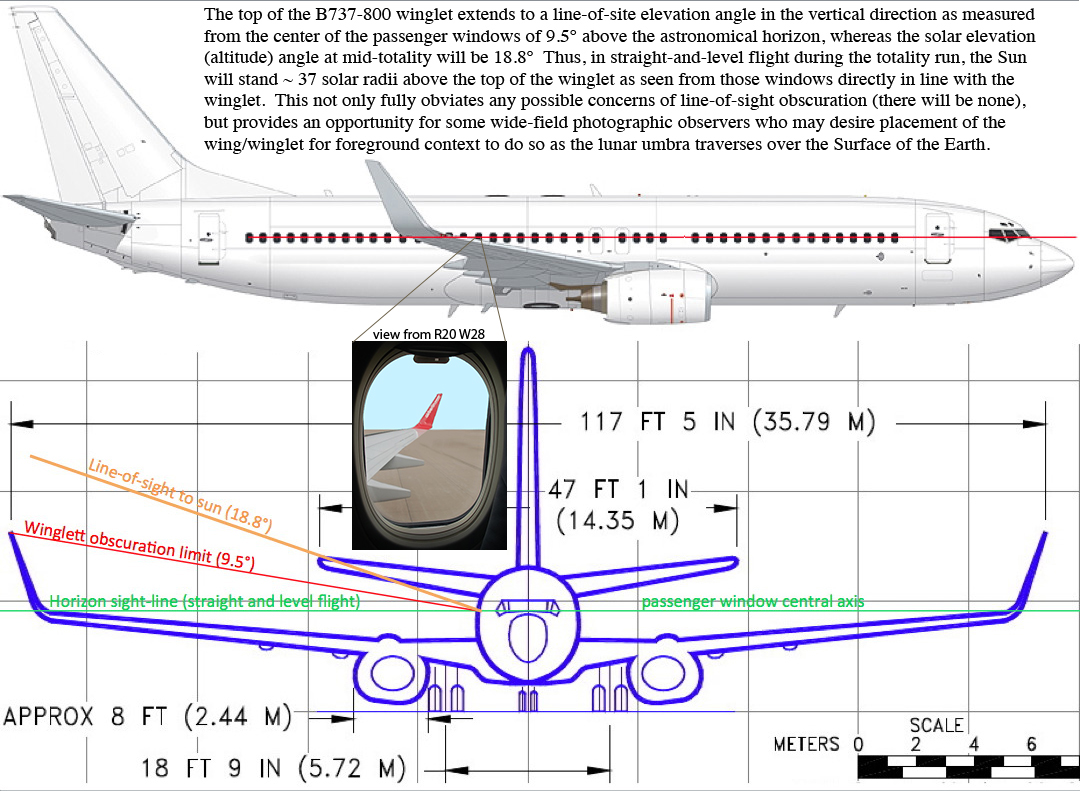
With a planning-baseline max-eclipse intercept point of (63.39154° N, 7.56084° W; see below "Why This Location?"), the fully-eclipsed Sun will stand 18.8° above the astronomical horizon (22.2° above the apparent horizon) allowing very easy and comfortable viewing out the aircraft sun (right) side passenger cabin windows, individually or shared with a window-viewing partner.
For those who want the maximum possible duration of totality EFLIGHT 2015 MAX, this appx 5 hour round-trip flight, is it!
With an at-altitude mid-eclipse occurring at 09h 43m 30s UTC, the duration of totality will be stretched to approximately 3m 45*s ± 10s, a minute longer than would be possible from a hypothetical Ocean-going vessel 11 km below, and appx. a minute and a half longer than will be seen from the Faroe Islands (should clouds below us cooperate for ground-based observers located there). *Duration with with no wind at Mach 0.78 (@ 37,000 ft), so a nominal ground speed of 447.4 nm/h.
 |
| Schematic Representation of the
End-to-End Flight Plan exclusive of planned contingency maneuvering to mitigate risks of ground or outbound cruise delays. |
With a planning-baseline max-eclipse intercept point of (63.39154° N, 7.56084° W; see below "Why This Location?"), the fully-eclipsed Sun will stand 18.8° above the astronomical horizon (22.2° above the apparent horizon) allowing very easy and comfortable viewing out the aircraft sun (right) side passenger cabin windows, individually or shared with a window-viewing partner.
For those who want the maximum possible duration of totality EFLIGHT 2015 MAX, this appx 5 hour round-trip flight, is it!
At |latitudes| > 60°, such as our MAX point of
mid-eclipse intercept, the tropopausal boundary between the troposphere
below (where "weather occurs") and the
stratosphere has typical equinoctial heights of < 9–10 km. Polar
stratospheric (nacrecous) clouds are extremely
rare and only form at
very
low temperatures (< -78° C) during the deep polar winter, making
the
probability of cloud-free eclipse viewing nearly 100% at our
equinoctial
flight
altitude of 37,000 ft (~11.3 km) at our chosen observing
location. Of course, we will have flexibility for in
situ retargeting (with a small trade in totality duration) of our
viewing locations if that is required for any
reason, however unlikely.
At this altitude and latitude, aerosol scattering of sunlight by airborne particulates is usually extremely low, giving rise to an exceptionally dark sky during totality, enabling eclipse viewing with significantly enhanced image contrasts. Moreover, the airmass along the line-of-sight to the Sun is significantly reduced (by ~ 75% compared to sea level), resulting in exceptional sky transparency, greatly reduced atmospheric turbidity, and better astronomical "seeing".
At 63° N, east of Iceland, the possibility of high-altitude volcanic ash originating in Iceland while statistically small is non-zero. Thus, for further (but intrinsically very-low) risk mitigation, we have designed our EFLIGHT 2015 MAX plan with sufficient flexibility to reach higher latitudes (with somewhat reduced maximum duration of totality) where such particulates are very unlikely to be transported given normal sub-polar wind circulation patterns.
We will be using an Air Berlin Boeing B737-800 (aka "738") aircraft, normally used for more "conventional" commercial service, from the Air Berlin fleet, with all economy class seating throughout the entire cabin as shown schematically below.
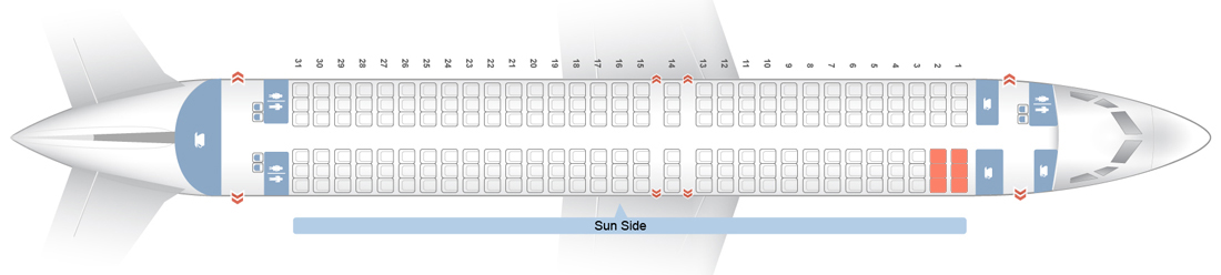
Sun-side eclipse-viewing windows ONLY will be openly offered for no more than 27 seating rows on the aircraft (first come first serve). Sun-side eclipse-viewing windows may (later on booking) be reserved for individual exclusive use, or shared with an adjacent seat-mate partner with a per-person pricing plan (details available from TravelQuest Tours).
The
passenger cabin windows on the right side of the aircraft will
be used
for eclipse viewing and photography. Seat offerings, and
on-board
operations
during the eclipse-viewing phase of the flight, have been designed to
provide an optimal eclipse observing experience. All rows offer
at least one window suitable for eclipse viewing* with those numbered
in green as annotated on the figure below fully unobscured with seat
backs in upright positions.
(*Row 11 with one window, and Row 13 with two, have window edges
marginally obscured as shown).
The locations of the windows on the cabin wall with respect to each of the passenger seat rows are illustrated in the figure below. To maximize the utility of all windows accessible to any seat row without interference to adjacent rows, seat backs in some specific rows may be tilted backwards to provide partial to full access to the window nearest the adjacent passenger seat (those identified in light blue) without compromising the useful window(s) in the seat row behind.

EFLIGHT 2105 MAX seat rows and their windows.
Further utility of the windows identified in light blue (only) can be gained by their exposure by seat back reclining.
Additional photographs, by row number, of the seat/window configurations, may be seen in photos --> HERE.
(1) Early Preparations: Detailed photographs and measurements of all seat rows and windows will be made available to eclipse viewers far ahead of the flight, to allow informed preparations by photographers, those using optical aides, and or planning window-sharing with a seat-row partner (see above).
(2) At Dusseldorf International Airport: our flight will be given first priority by Air Berlin's handling, ground operations, flight planning and in-flight will also be communicated as priority 1 towards Air Traffic Control and for inter-flight coordination.
(3) Our Outbound Flight Plan: is baselined for a 45 minute earlier than critically required take-off time, providing built-in contingency time against the possibility of a take-off delay or strongly unfavorable outbound head-winds.
(4) Windows Quality/Frost Risk Mitigation: The specific Air Berlin B737-800 we will use will be one of the very newest in their aircraft fleet with very fresh windows with minimal scratches or sleeks that could otherwise act as frost-formation centers. Cabin air will be pre-conditioned to reduce the potential and minimize the (unlikely) risk of frosting, and the aircraft will then remain at high altitude prior to totality (no descents for "flightseeing") to keep the relative humidity on potential frost-forming surfaces low. Additionally, not all available seat-rows with eclipse viewing windows will be offered to keep several in reserve for viewing position exchange, in the unlikely event of individual anomalous window frosting elsewhere in the aircraft.
(5) No Extraneous Passengers: This is a dedicated eclipse-viewing flight. No seats will be offered on the anti-sun side of the aircraft for others to "fill" the aircraft. No potential over-crowding, no unintentional interference or distractions during the totality run to eclipse-viewers.
(6) During the Totality Run: Eclipse observing will be conducted without any intra-eclipse "seat swapping/rotation" of positions with excess passengers (obviated by (5)) otherwise disturbing/interfering with same, or adjacent row eclipse-viewers. This "exclusive" or pre-planned partner-shared use only of the windows will enable an atmosphere much more conducive to concentrated and uninterrupted eclipse viewing.
(7) Throughout All Flight Planning and in situ until CIII on the Aircraft: Dr. Glenn Schneider will act actively as the consulting expert with the mission planners and flight crew to assure the smooth execution of the totality run and mid-eclipse intercept per the baseline plan and in response to any in-flight deviations.
(8) Post-Totality: Upgraded catering and celebratory imbibement after collecting solar coronal photons to revel in our successes.
The locations of the windows on the cabin wall with respect to each of the passenger seat rows are illustrated in the figure below. To maximize the utility of all windows accessible to any seat row without interference to adjacent rows, seat backs in some specific rows may be tilted backwards to provide partial to full access to the window nearest the adjacent passenger seat (those identified in light blue) without compromising the useful window(s) in the seat row behind.
EFLIGHT 2105 MAX seat rows and their windows.
Further utility of the windows identified in light blue (only) can be gained by their exposure by seat back reclining.
Additional photographs, by row number, of the seat/window configurations, may be seen in photos --> HERE.
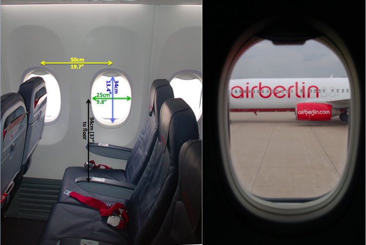
WINDOW METROLOGY
Flight participants can
individually, or as partners sharing a seat-row, assess their needs for
using their seat-row window(s) as a viewing and/or photography
portal. All windows are rectangular in shape, 25 cm (9.8" wide)
by 34 cm (13.4") high, with rounded corners imposed by the cabin wall
framing -- see pictures below. The center of the windows are 94
cm (37") from the main cabin floor. The inter-window spacing
(cadence) is 50 cm (19.7") for all windows except for a "missing"
window between rows 11 and 12 (see photos above), and w.r.t. the
windows in the emergency row doors (rows 14 and 15; whose window shade
tabs protrude from the bottom rather than the top).
ABOUT THE
AIRCRAFT WING AND OUTBOARD (VERTICAL) WINGLET
(1) Early Preparations: Detailed photographs and measurements of all seat rows and windows will be made available to eclipse viewers far ahead of the flight, to allow informed preparations by photographers, those using optical aides, and or planning window-sharing with a seat-row partner (see above).
(2) At Dusseldorf International Airport: our flight will be given first priority by Air Berlin's handling, ground operations, flight planning and in-flight will also be communicated as priority 1 towards Air Traffic Control and for inter-flight coordination.
(3) Our Outbound Flight Plan: is baselined for a 45 minute earlier than critically required take-off time, providing built-in contingency time against the possibility of a take-off delay or strongly unfavorable outbound head-winds.
(4) Windows Quality/Frost Risk Mitigation: The specific Air Berlin B737-800 we will use will be one of the very newest in their aircraft fleet with very fresh windows with minimal scratches or sleeks that could otherwise act as frost-formation centers. Cabin air will be pre-conditioned to reduce the potential and minimize the (unlikely) risk of frosting, and the aircraft will then remain at high altitude prior to totality (no descents for "flightseeing") to keep the relative humidity on potential frost-forming surfaces low. Additionally, not all available seat-rows with eclipse viewing windows will be offered to keep several in reserve for viewing position exchange, in the unlikely event of individual anomalous window frosting elsewhere in the aircraft.
(5) No Extraneous Passengers: This is a dedicated eclipse-viewing flight. No seats will be offered on the anti-sun side of the aircraft for others to "fill" the aircraft. No potential over-crowding, no unintentional interference or distractions during the totality run to eclipse-viewers.
(6) During the Totality Run: Eclipse observing will be conducted without any intra-eclipse "seat swapping/rotation" of positions with excess passengers (obviated by (5)) otherwise disturbing/interfering with same, or adjacent row eclipse-viewers. This "exclusive" or pre-planned partner-shared use only of the windows will enable an atmosphere much more conducive to concentrated and uninterrupted eclipse viewing.
(7) Throughout All Flight Planning and in situ until CIII on the Aircraft: Dr. Glenn Schneider will act actively as the consulting expert with the mission planners and flight crew to assure the smooth execution of the totality run and mid-eclipse intercept per the baseline plan and in response to any in-flight deviations.
(8) Post-Totality: Upgraded catering and celebratory imbibement after collecting solar coronal photons to revel in our successes.
| BASELINE PLANNING ASSUMPTIONS: Flight Level = FL 37,000 ft No Wind, TAS = Ground Speed = Mach 0.78 @ FL 37,000 ft Delta-T: 67.8 seconds (current IERS prediction for March 2015) Geodetic Coordinate Reference Frame: WGS84 KEY FLIGHT/INTERCEPT PARAMETERS: AIRCRAFT B737-800 PROFILE CONCEPT LONGEST DURATION LAUNCH POINT (LP) DUSSELDORF INT. AIRPORT DESIGNATION DUS (EDDL) LAUNCH POINT LOCATION 51.28944° N, 6.76666° E OUTBOUND CONTINGENCY "BUFFER" 45 minutes FLIGHT LEVEL 37,000 ft (11,278 m) AMSL MID-ECLIPSE (ME) INTERCEPT [a] 63.39 154° N, 7.56084° W UTC ME INTERCEPT 09:43:30 UTC G.C. DISTANCE FROM LP to ME 859.69 nm BASELINE TAS = GROUND SPEED [b] 447.4 kts (Mach 0.78) GROUND TRACK AZIMUTH @ ME [c] 43.3° DURATION OF TOTALITY [d] 3m 45.1s ME SOLAR ALTITUDE ANGLE [e] 18.8° ME SOLAR AZIMUTH ANGLE 133.3° SURFACE-OBSERVER DURATION 02m 46.8s TOTALITY RUN TIMESPAN [f] -9, +6 minutes BASELINE TOTALITY RUN: TR-START TIME UTC 09:34:30 UTC TR-START LOCATION 60.15964° N, 13.62041° W TR-ME INTERCEPT UTC 09:43:30 UTC TR-ME LOCATION 63.39154° N, 7.56084° W TR-END TIME UTC 09:49:30 UTC TR-END LOCATION 65.77103° N, 3.64945° W |
NOTES: [a] For initial baseline planning a "no wind" condition is assumed. So, GROUND SPEED (GS) = TRUE AIR SPEED (TAS). This is tunable with predicted winds aloft. [b] LONGEST DURATION ME remains constant +/- 0.05 seconds over an an on-centerline distance of 45.78 nm starting at the location indicated for baseline ME as follows: UTC Intercept Duration Intercept Location GC to ME 09:43:30.0 3m 45.1s 63.39154°N, 7.56084°W 859.69 nm <ME START 09:44:18.0 3m 45.1s 63.69695°N, 7.03965°W 865.60 nm <ME CENTRAL 09:45:05.0 3m 45.1s 63.99930°N, 6.53004°W 872.35 nm <ME EXIT ME START selected for baseline intercept within this window to reduce total flight distance from Dusseldorf without impact on maximum possible duration of totality. [c] Aircraft Ground Track to orient sun at ME orthogonal to ("straight out") the sun (right) side PAX windows. Heading tunable based on actual winds aloft. Ground track (with winds aloft) should be maintained. [d] As corrected for topocentric lunar limb profile (complete photospheric extinction). [e] Above the astronomical (true) horizon. [f] Totality-Run Timespan: Centered on UTC of ME. • Totality Run Start (TR-START) at indicated UTC/LOCATION to commence at UTC of ME minus 9 minutes. • Aircraft MUST then be at this location and flying straight-and-level on indicated course to TR-END. • Totality Run End (TR-End) at indicated UTC/LOCATION to end at UTC of ME minus 6 minutes. • Post C3, TR may be extended beyond TR-END at pilot's discretion. |
The track, geometry, and location of the path of totality, and the time-correlated UTCs of key eclipse events (e.g., start, end, and middle of totality) that ultimately constrain an end-to-end eclipse-observation flight plan, as seen from a moving aircraft, will depend in detail on the aircraft altitude above mean sea level and its velocity vector (ground speed and direction) as modified by winds aloft. Baseline (Phase 1) eclipse-flight planning (as discussed and presented here) makes assumptions for later (Phase 2) optimization and refinement within constrained margins with dependencies on in situ conditions that may be parametrized in final computations. A baseline flight plan is developed to provide a framework to be refined for an executable flight mission subject to refinements and constraints levied by aircraft performance and operations factors. Phase 2 "fine tuning" of the flight plan (e.g., in light of statistically anticipated and actual winds aloft) is later expected.
 |
 |
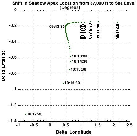
| Eclipse
circumstances are dependent upon observer's height above mean sea
level (AMSL). The time-correlated position (centerline track) of the
Moon's shadow shifts in latitude and longitude with topocentric
altitude AMSL. This is illustrated by example for TSE 2015 with the
difference in centerline topographic coordinates at 37,000 ft compared
to sea level. |
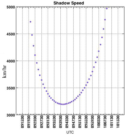
The speed of
the Moon's shadow projected on the surface of the Earth varies
significantly along the path of totality. Where slowest, the
duration of totality is near maximum. The shadow speed can
advantageously be reduced, prolonging totality, with an aircraft moving
in the direction of the lunar velocity vector. |
For EFLIGHT 2015 baseline
planning purposes, here we adopt a flight
altitude for the eclipse-observing phase of the flight (and nominal
out/inbound cruise phases) of 37,000 ft AMSL. Here (for initial
planning), a no-wind condition is assumed and a TAS of Mach 0.78
(i.e., ground speed equals
airspeed) during at-altitude cruise. We designate a "Totality
Run" as that portion of the
flight devoted to the observation of the total phase of the eclipse.
The Totality Run is planned so the aircraft has assumed
straight-and-level flight (nominally) at constant speed at and
throughout the totality and
during pre/post flanking intervals closely prior to and after
totality.
The point (time correlated location and UTC) of "mid eclipse" (ME) intercept is the instant at which the aircraft is concentrically located in the Moon's umbral shadow. The totality run is planned so the aircraft heading is the solar azimuth at ME minus 90 degrees, so the Sun will present itself "straight out" the sun-side passenger windows. This is the right (starboard) side of the aircraft, so enabling an aircraft velocity vector component in (not against) the velocity vector of the Moon's shadow with a resulting increase in the duration of totality as seen from the moving aircraft.
In practice, small compensating adjustments to the derived totality run (and pre-totality run flight plan) based upon:
(a) TBD (Phase 2) statistically most-likely, and/or in situ actual winds-aloft,
(b) different (faster is better for longer totality) TAS during the totality run within operating limits, and
(c) different (higher is better for sky clarity) flight level to the limit of the service ceiling with trade of achievable ground speed.
Such parametrically defined variations to the baseline flight plan, subject to aircraft operational and performance constraints, will be reviewed and discussed with the aircraft flight operations and planning personnel, and are readily (re)-computatble as needed. (See here an overview of the EFLIGHT planning S/W [20 MB PDF file], developed and used by G. Schneider for many prior successful EFLIGHTs.
The baseline flight plan presented here is of sufficient fidelity for the (presumed nominal) parametric conditions assumed that, if rigorously followed, will successfully result in a highly viewing-optimized and geometrically precise time-correlated mid-eclipse intercept with the aircraft concentrically located along the apex of the lunar umbral shadow cone.
N.B.: All timings and correlated locations, and maps presented here are (in detail) valid ONLY for the specific set of baseline assumptions used here. Later recomputation of the eclipse observation plan (and thus to a small degree end-to-end) flight plan, based upon parameterization a-c above, is expected and anticipated.
The totality run (TR) is entered (nominally) at the completion of a heading re-alignment maneuver (with a constant-radius turn onto the TR track) at the requisite UTC, location, altitude, TAS, and heading. Once on the TR track, before the start of totality (C2 = "second contact"), small adjustments to the aircraft speed may be made to compensate for winds-aloft or turn-exit navigation errors to maintain the desired mid-eclipse flight profile.
N.B.: The specific pointg of mid-eclipse intercept results in a totality duration appx 0.05s (insignificantly) shorter than the absolute theoretical maximum (for this set of flight parameters) for this eclipse. This was arrived at from a cost/benefit trade to reduce the overall flight distance R/T from Dusseldorf while retaining in-flight contingency margins,
The detailed definition of the EFLIGHT 2015 MAX baseline flight plan was developed to optimize the observing opportunity while minimizing to near-zero risks that are otherwise high-probability at ground-based locations. The nominal (baseline) flight plan is built around an eclipse-viewing "totality run" (TR) constrained by celestial mechanics, aircraft operational considerations, and a need to maintain in situ flexibility to implement contingency alternatives. For baseline planning and logistical purposes we build from: (1) a flight altitude for eclipse-viewing of 37,000 feet AMSL, with (2) a ground speed of 447.4 nm/hr and (3) no wind (so ground speed = air speed, and heading = course). Detailed pre-eclipse flight planning, and in-flight execution, will incorporate and allow for the full range of possible flight levels, air speeds, and wind-vectors that may be encountered in flight to re-optimize the totality runs in situ as may be necessary or desired.
We define the baseline totality run such that the aircraft is centrally located at the apex of the lunar umbral shadow (but corrected for the irregular lunar-limb profile) at the topocentric instants of "maximum eclipse" at the chosen intercept point. We also define the baseline totality run so that the aircraft velocity vector at mid-eclipse places the Sun "straight out" the right-side windows of the aircraft passenger cabin to provide optimum out-the-window viewing and utilization. This orientation also provides an optimal orientation to prolong the duration of totality to a theoretical maximum anywhere along the path of totality by using the aircraft's speed to (partially) keep pace with the lunar shadow. With these constraints, we compute, and tabulate below, three key time correlated waypoints for the totality runs that define the lunar shadow intercept and crossing by the aircraft designated C2 (eclipse contact II), MAX (corresponding to the UTC instant of maximum eclipse), and C3 (eclipse contact III). MAX, in both UTC and lat/long, will depend upon the aircraft altitude AMSL. C2 and C3 will also depend upon the aircraft ground speed and track (i.e., airspeed and winds aloft).
The (earlier) start of the pre-totality leg of the totality run is be defined by a pre-totality time-correlated waypoint nine minutes before mid-eclipse. The aircraft is initially positioned on the MAX-eclipse intercept track at the requisite course/heading, distance, and flight-time from the intercept point allowing for airspeed adjustment in the run up to the C2 time-correlated waypoint to compensate for deviations due to actual (vs. predicted) winds aloft (holding the MAX intercept time-correlated waypoint invariant). After C3 the aircraft will remain on the MAX-to-C3 heading for 6 minutes following mid-eclipse to allow viewing of the recession of the Moon's shadow before returning back to Dusseldorf.
TIME-CORRELATED
WAYPOINTS and ECLIPSE CIRCUMSTANCES FOR EFLIGHT 2015 MAX
Flight scenario: FL 370, Mach 0.78 (TAS 447.4 nm/hr). No statistical winds assumed.
(Details Subject to Change)
Flight scenario: FL 370, Mach 0.78 (TAS 447.4 nm/hr). No statistical winds assumed.
(Details Subject to Change)
| ## |
FLIGHT
PLAN PHASE/DESCRIPTION |
U.T. |
Long. |
Lat. |
Bearing° |
Dist
dist(nm) |
Leg
time |
Alt° | Az° |
| 01 |
NOMINAL
Wheels-Up
Dusseldorf |
06:51:07 |
6.76666° E | 51.28944° N | 328.3 |
0.0 |
|||
| 02 |
ASCENT:
Est.
Climb to FL 370 (TBD) |
156.0 |
24m
00s |
||||||
| 03 |
START
OUTBOUND CRUISE |
07:15:31 |
4.48331°
E |
53.47821° N | 326.5 |
||||
| 04 |
Outbound Cruise |
690.7 |
1h
32m 38s |
||||||
| 05 |
Contingency Buffer Start |
08:48:09 |
At pilot's discretion / direction in response to in situ conditions |
45m |
|||||
| 06 |
Contingency Buffer End |
09:33:09 |
|||||||
| 07 |
END
OUTBOUND CRUISE and START PRE-TR CONSTANT RADIUS TURN |
09:33:09 |
9.20690° W |
62.42545° N |
|||||
| 08 |
86.6°
Constant Radius Right Turn
Center TBD: 25° bank, 1.35 min, Rad: 6.4 nm |
9.04412°W
|
62.50048°
N
|
9.7 |
1m 21s |
||||
| 09 |
Totality
Run Start (ME - 9 min) - Mach 0.78 |
09:34:30 | 9.21557° W | 62.57147° N | 41.8 | 17.9 |
129.2 | ||
| 10 |
WANING
SOLAR CRESCENT VIEWING |
52.7 |
7m
05s |
||||||
| 11 |
2nd Contact (C2) |
09:41:35 |
7.92106° W | 63.21854° N | 43.0 |
18.6 |
132.4 |
||
| 12 |
TOTALITY |
14.3 |
1m
55s |
||||||
| 13 |
Mid-Eclipse (Umbral Axis
Intercept) |
09:43:30 |
7.56084° W | 63.39154°
N |
43.3 |
18.7 | 133.3 | ||
| 14 |
TOTALITY |
13.8 |
1m
51s |
||||||
| 15 |
3rd
Contact (C3) |
09:45:21 |
7.20902° W | 63.55765° N | 43.6 |
18.9 |
134.2 |
||
| 16 |
WAXING SOLAR
CRESCENT VIEWING |
30.9 |
04m
09s |
||||||
| 17 |
Totality Run End (ME + 6 min) | 09:49:30 | 6.40478° W | 63.92706° N | 44.7 | 19.2 | 136.1 | ||
| 18 |
100.2°
Constant Radius Right Turn
Center TBD: 25° bank, 1.56 min, Rad: 6.4 nm |
6.23351° W |
63.85217° N |
11.2 |
1m 34s |
||||
| 19 |
START
INBOUND CRUISE |
09:51:04 |
6.03594°
W |
63.91317°
N |
|||||
| 20 |
Inbound Cruise |
145.8 |
710.7 |
1h 35m 18s |
|||||
| 21 |
End
Inbound
Cruise and Start Descent |
11:26:22 |
5.110876° E | 53.57091° N | |||||
| 22 |
DESCENT
from FL 370 |
150.0 |
24m
00s |
||||||
| 23 |
Wheels-Down
Dusseldorf |
11:50:22 |
6.76666° E | 51.28944° N | 155.4 |
||||
| TOTAL TIME and DISTANCE |
1840.0 |
4h 59m 15s | |||||||
| Notes:
(1) Totality run to place the Sun "straight out" the main
cabin windows at
mid-eclipse. (2) No statistical (i.e., anticipated seasonal average) wind vectors have been (yet) been assumed. (3) Constant radius turns onto/off the TR track assume a bank angle (and thus derived turn radius/duration) of 25° (4) Ascent and Descent profiled durations and ground-track distances are to-be-verified (5) Geodetic co-ordinate reference frame is WGS84 (6) Delta-T: 67.8 seconds (Current IERS derived prediction for March 2015) |
|||||||||
The
end-to-end (wheels up to wheels down) flight planning seamlessly
merges into the immutable (but tunable based on actual flight
conditions) Totality Run. Most critical is entering the
pre-planned Totality Run exactly as specified with minimal error.
Any "delay" and the Moon's shadow will pass over the location where the
aircraft should have been and totality will be missed. This MUST,
and will be, be avoided.
(1) Take-off. To mitigate against the operational possibilities "time-critical" take-off delay from DUS for any reason, an earlier than time-critical wheels-up time for a central intercept at the chosen mid-eclipse intercept point is planned. This is 45 minutes. See item (4) below on "Buffer" time.
(2) Ascent (and Descent). This phase of the flight must be defined in detail by the aircraft flight planners. For Phase 1 planning an estimated climb to FL 370 consuming 24 minutes of time and covering 156 nm (ground track), and descent over 150 nm in 24 minutes.
(3) Cruise and Totality Run Speeds. An "most economical" TAS cruise speed of Mach 0.78 is suggested (and used) for initial planning. This, importantly, provides some leverage to invoke higher or lower cruise speeds (within performance limits) to allow mitigation against unfavorable head or tail winds that would otherwise result in a too-early or too-late arrival at the TR start point, or during time/position decorrelation during the TR itself. Performance options that may be invoked are to be discussed with the flight crew and operations planners.
(4) Buffer Time. In the event of an on-schedule (prudently planned) earlier than time-critical, takeoff , this "extra" (i.e., "buffer") time programmed into the flight plan to otherwise compensate for a delay must be consumed by either maneuvering enroute, and/or flying at a slower TAS to the time-critical TR start point. This is a detail of the flight planning that will necessarily worked in concert with the flight crew and flight planners (given airspace and other operational constraints) at a later date closer to eclipse time. A placeholder for this outbound navigational contingency "buffer" is stipulated in the end-to-end plan, and implementation details will be worked later in Phase 2 planning with the pilot in command and flight planners.
The baseline end-to-end flight plans
are designed to allow for delays
in reaching their time-invarient totality-run start points, beyond
those that can be accommodated by the adjustment range of the aircraft
speed, by up to 45 minutes. The NOMINAL baseline plan defines an
earlier than critical wheels-up take-off time from Dusseldorf [00].
Margin is provided to accommodate for such delays with a pre-allocated
contingency in-flight maneuvering "buffer" of variable duration [05-06]
of up to 45 minutes after reaching outbound cruise [03] prior to a
UTC-correlated entry onto the totality run [09]. The specific
maneuvering required to consume this buffer will depend upon the actual
take-off time. Two generic scenarios are suggested here,
but left to the discretion of the pilot in command with a requirement
to re-merge onto the nominal flight plan at item [09] for the start of
the time-critical totality run:
(1) (Conceptually) flying "zig-zags" traversing the outbound cruise leg. This provides maximum flexibility against an arbitrarily long take-off delay without the necessity of retargeting for a different (less optimal) mid-eclipse intercept point within reachable limits.
(2) Repositioning the heading re-alignment maneuver following the outbound cruise phase to a point earlier time, and thus to a location to the south-east of the totality run start point. I.e., establishing earlier a straight-and-level approach to totality run start point and effectively extending the pre-totality portion of the totality run. This presents a "lower risk" of navigation error by placing the aircraft in situ within the path of totality for a longer duration before totality begins. Pre-planned contingency, and/or in situ, repositioning will be aided and enabled through the use of G. Schneider's EFLIGHT eclipse flight optimization and navigation software.
Contact: Dr. GLENN SCHNEIDER at gschneider@mac.com
Who is Glenn Schneider? SEE HERE (eclipse
context). SEE HERE
(astronomical context).
Please
note, I myself am an
astronomer, and I am not in (nor do I
intend to be) in the aviation, or tour business. Here,
for
EFLIGHT 2015, as for all previous EFLIGHTS I have motivated and
designed, I
serve to facilitate the enabling, technical planning, implementation
and execution. I am happy to take any technical, operational, or
logistical questions regarding this flight. Questions about, or
requests for, flight bookings should be directed to TravelQuest
International
(1-800-830-1998 toll free in the USA or +1 928 445 7742 elsewhere).
UPDATES,
CONTACT,
AND ADDITIONAL INFORMATION
I will endeavor to keep all who are interested appraised of any/all new developments through this web page as the EFLIGHT 2015 MAX implementation plan is further matured in collaboration with the Air Berlin flight planning/operations groups and our flight crew. Please check back again at this page's URL. Additional links will later be provided as appropriate/necessary. I can be contacted by my email address gschneider@mac.com, with also the additional/alternate contact information:
Dr. Glenn Schneider
Astronomer and EXCEDE Project Principal Investigator
(Member: IAU Div. 2 Working Group on Solar Eclipses)
Steward Observatory and the Department of Astronomy
The University of Arizona
Tucson, Arizona 85721 USA
email: gschneider@as.arizona.edu
Telephone: 520-621-5865
URL: http://nicmosis.as.arizona.edu:8000
last update: 14 September 2013