11
JULY 2010 TOTAL SOLAR ECLIPSE
GROUND-BASED
EXPEDITION TO HAO ISLAND ATOLL, FRENCH POLYNESIA
PLUS
LIMITED-AVAILABILITY OPTIONAL ADD-ON
>
9 MINUTE DURATION
TOTALITY HAO-LAUNCH & RETURN ECLIPSE FLIGHT
ORIGINATING
FROM AND RETURNING TO LOS ANGELES, CALIFORNIA USA
Glenn Schneider, Steward Observatory, University of Arizona
Phone: 520-621-5865, email: gschneider@mac.com
Total solar eclipses (TSEs) are one
of nature's most dramatic and awesome spectacles - but often occur in
remote locations posing logistical (and financial) barriers to
accessibility. The most recent TSE, on 22 July 2009, was visible
from
highly populated areas in India and China, and provided the opportunity
for those who ventured to the point of maximum eclipse in the
Pacific Ocean (e.g., on the Costa Classica cruise organized by Roy
Mayhugh and
"
Astronomy Vacations")
to view the longest land- or sea-based total
solar eclipse for more than a century to come. But, many were then
left wondering "what about the NEXT one?" The path of totality
for
the 11 July 2010 solar eclipse soon to be upon us, traverses a vast,
but narrow,
stretch across the south Pacific Ocean (see map below) — with landfall
opportunities few
and far between on
only a very small number of sparsely populated islands. Just
moments before sunset umbral landfall occurs in Patagonia, but eclipse
visibility will be problematic in the limited locations there where the
path can be
accessed both because the local climate presents a very high likelihood
of cloud cover and mountains to the west will block many lines-of-sight
to the horizon-hugging setting Sun.

The total phase of the 11 July 2010 solar eclipse will be visible only
from within the "path of totality" — the narrow arc-like strip on the
map above — centered on the southern Pacific Ocean.
(Map source: NASA
TP/2008-213171
by Espenak and Anderson)
Most of the few small Pacific islands that will be immersed in the
moon's umbral shadow are difficult to access and lack
infrastructures capable of supporting anything but, at best, very small
numbers of eclipse chasers. For years (if not decades), Easter
Island, Chile, within the eastern part of the path of totality, has
drawn the attention of eclipse chasers in anticipation of TSE 2010
because it does routinely entertain tourist visits both by commercial
air and
visiting cruise ships, but only in very limited numbers. While
some eclipse chasers will be headed
that way, Easter Island is quickly reaching its capacity for hosting
eclipse observers. Moreover, it is in the comparatively drier portion
of the track passing through French Polynesia where eclipse-obscuring
clouds are less likely than points further east (i.e., Easter island
and Patagonia), or further west (i.e., Cook Islands).
Small aircraft can provide transport
to a few small in-totality islands in French Polynesia, but only in
very limited numbers. The solitary exception is the often
overlooked Hao Island Atoll, about 920 km (497 nautical miles) east of
Tahiti —
quite off the beaten path of "normal" island tourism in French
Polynesia. Hao Island has a population of appx 1,200 in a single
village
on its northeast side named Otepa primarily sustained by pearl
harvesting.
A view of the Hao Island marina at the
village of Otepa.
Other than Easter Island (Chile), Hao Island (French Polynesia) is the
only island within the path of totality with an airport facility
capable of accommodating a large commercial jet aircraft filled
with eclipse chasers!
The Hao Island atoll quietly
boasts an 11,089 foot x 148 foot (!) hard surface runway and
airport complex — nestled between the surf-breaking shores of the
Pacific Ocean and the island's interior lagoon where TSE 2010 will be
observed right from the airport with a totality duration of 3m 37s and
the Sun 33° above
the horizon at mid-eclipse.
HAO
ISLAND, FRENCH POLYNESIA:
- Location:
920 km (497 nautical miles) east of Tahiti
- Geographic
Coordinates (airport runway): 18° 04' 21.00" S, 140°
56' 53.94" W
- Local Time
Zone: UTC/GMT -10 hours
- Airport Code: HOI
- Hard Surface
Runway: 11,089 x 148 feet (3380 x 45 meters)

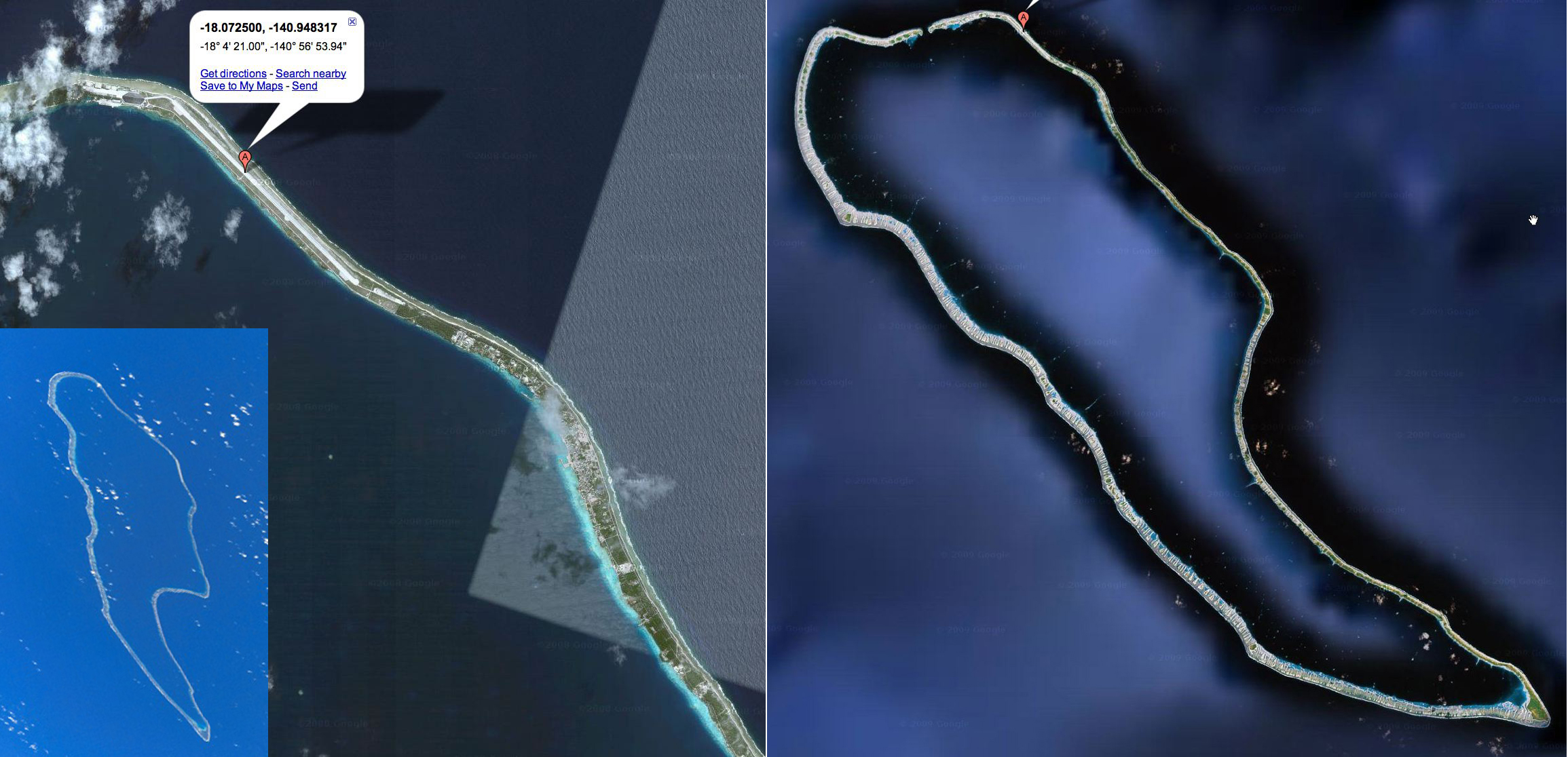
Hao Island as seen from above.
Left panel: The northeast side of the island showing the 11,089 foot
(3,380 meter) runway. The airport complex is to the northwest,
and the village of
Otepa is to the southeast, of the runway. Inset: Hao as seen from
the space
shuttle (unrectified image, looking down at where they hoped
not to land) from STS-100 on 28
April 2001. Right: Rectified image of Hao Island, approximately
55 km from the NW to the SE ends. Image sources: NASA
and Google Maps.
CLICK on
the
above image to see at twice the resolution, or click
HERE
to explore the Hao Island airport with Google Maps.

Hao Island airport operations, aircraft service, and support facilities
and structures.

Given its small population and
geographically remote location, why does Hao Island have such a
significant airport facility? Historically, Hao Island was a
logistical staging area for the now-terminated French nuclear testing
program. Subsequently, the air facility became designated as a
space shuttle emergency landing facility (but, thankfully, has never
had to be used for that purpose!). More recently, Hao Island
airport was turned over from military to civilian French
Polynesian operating authority (click
HERE
for the current Air (Operations) Directive for Hao). Today Air
Tahiti — the regional carrier for French Polynesia, not to be confused
with Air Tahiti Nui, the international carrier — operates a limited
number of inter-island flights to and from Hao on smaller
aircraft. Although the Hao Island airport is capable of servicing
large, long-range commercial jet aircraft, there has
never been any need for it to do so — until now.
Additionally,
the Hao
Island
atoll serendipitously finds
itself in a "sweet spot" in longitude along the path of totality —
centrally within a climatological local minimum in mean cloud amount,
making it the ideal place for eclipse chasers to deploy for TSE 2010.
Comparison of historical July
average cloud obscuration (weighted by sky coverage
and frequency of occurrence) among ground-based, potentially
accessible, observing locations. Climatology data adapted from Jay
Anderson;
see
additional data for other longitudes and locations.
Comparison of July monthly mean cloud
cover frequency (percentage of time) as a function of cloud
obscuration, as
compiled by Jay Anderson, for Hao Island and Easter Island.
Easter Island experiences heavy (median 75%) broken
to
fully overcast skies significantly more frequently than Hao Island.
Conversely, and favorably, less-obscuring light (trace or scattered)
cloud cover is more
frequent on Hao Island than on Easter Island.
Because
of the advent of the 11 July
2010 eclipse visible from the airport facility at Hao, and the likely
highest ground-based probability of clear skies, we are arranging
a charter flight of a large capacity long-range jet aircraft
originating from and later returning to Los Angeles, California, USA to
bring approximately 300 people to Hao directly from LAX to view TSE
2010.
Definitive departure and arrival times from (and back to) LAX are still
TBD, but our charter flight will be scheduled to arrive on Hao
at least three
hours before eclipse first contact. The aircraft will remain on
Hao until
approximately 3 hours after fourth contact (so, bring a bathing suit
for a
post-eclipse celebratory swim!). See the preliminary Hao Island
schedule
below.
PRELIMINARY HAO ISLAND
SCHEDULE (subject to change and optimization)
|
U.T.
|
Local (UT -
10h)
|
Alt°
|
Az°
|
Hao Latest Aircraft Arrival
|
14:25
|
04:25
|
|
|
Hao, Sunrise
|
15:59:40 |
05:59:40 |
0
|
66.7
|
(Est. EFLIGHT Take-off)
|
est 17:16
|
est 07:16
|
|
|
Hao, 1st Contact
|
17:24:39 |
07:24:39
|
18.0
|
58.6
|
Hao, 2nd Contact
|
18:41:23 |
08:41:23
|
32.6 |
47.4
|
Hao, Mid-Eclipse
|
18:43:11 |
08:43:11
|
32.9
|
47.1
|
Hao, 3rd Contact
|
18:45:00 |
08:45:00
|
33.2
|
46.7
|
Hao, 4th Contact
|
20:12:57
|
10:12:57
|
45.8
|
25.8
|
| (Est. EFLIGHT Landing) |
est 21:38
|
est 11:38
|
|
|
| Hao, Earliest Aircraft Departure |
est 23:00
|
est 13:00
|
|
|
Hao, Sunset (after departure)
|
02:59:05 12
July
|
16:59:05 11
July
|
0
|
293.2
|
Local
eclipse circumstances for Hao Island airport (18° 04' 21.00"
S, 140°
56' 53.94" W). Totality duration = 3m 37s.
|
But wait... There's MORE!
After arriving on Hao, approximately 250 island-based observers will
deplane and prepare to observe the eclipse. But, since the
charter aircraft "is ours"...
We
will then launch
a mission-optimized "add-on" eclipse flight (EFLIGHT 2010) from Hao
Island using the same aircraft to carry up to approximately 50 people to
view totality from ~ 11 km (36,000 ft) above the surface of the Earth yielding
a duration
of totality of approximately 9m 13s!

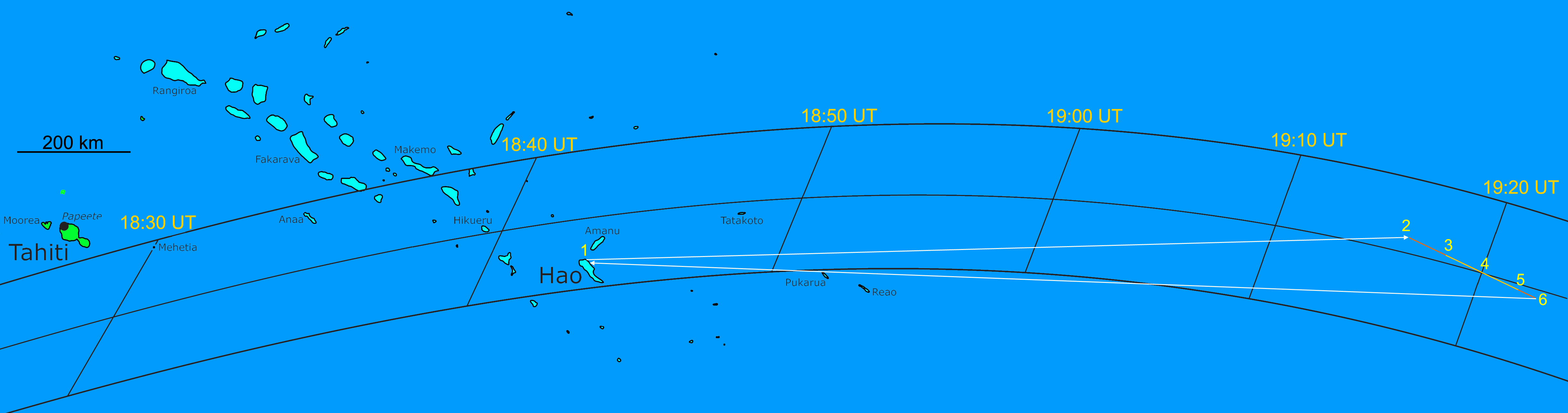
Our baseline EFLIGHT 2010 flight scenario is illustrated
above (click on the map to see it at a larger scale). After bidding a
fond pre-eclipse farewell to our ground-based friends on Hao Island,
EFLIGHT 2010 will launch from the Hao airport (1) at approximately
17:15 UT to rendevous with the moon's umbral shadow. After
traveling eastward for approximately two hours, at five minutes before
second contact, the aircraft will execute a shallow right hand turn (2)
turn to place it on a track (the
totality
run) so it will pass centrally through the umbra at mid-eclipse
with the Sun "straight out" the left side windows. (3) — At
second contact (19:15:24 UT) the leading edge of the umbra will
overtake the aircraft and a glorious diamond ring effect (see middle
picture below from EFLIGHT 2008) will be prolonged by the aircraft's
speed relative to the Moon's shadow. (4) — At mid-eclipse (19:20
UT) with the aircraft on centerline and located centrally
in the Moon's shadow, it will be most deeply immersed in the Moon's
shadow giving spectacularly high contrast views of the solar corona
from 36,000 feet. (5) — It's over! A parting third contact
diamond ring, and a total solar eclipse for the record books with over
9 minutes of totality observed! We then remain on the totality
run track for another 2 – 3 minutes taking advantage of views to the
horizon more than 350 km away at our altitude to watch the umbra in the
sky above and projected on the ocean below whisk ts way toward southern
South America before returning to space. We then execute a right
hand turn to begin our approximately two hour westward return flight
back to Hao Island, to join in the post-eclipse celebration back on the
ground.
Note: The number of EFLIGHT 2010 participants will be
limited by
the number of Sun-side (left side) windows on the aircraft to about 50
people. From our flight altitude of approximately 36,000 feet our
view of totality will be unaffected by cloud and local weather below.
We currently are planning to target for a mid-eclipse central
umbral-shadow intercept at 19:20 UT.
EFLIGHT 2010 — 11 JULY 2010 TOTAL
SOLAR ECLIPSE AT 19:20 UT (Flight
Level 36,000 ft., Ground Speed 490 nm/hr)
|
U.T.
|
Local
(UT-10h)
|
Alt° |
Az° |
Long.
|
Lat.
|
Dist (nm)
|
Est. Latest Wheels-Up Hao
|
17:16
|
07:16
|
|
|
|
|
0.0
|
EFLIGHT 2nd Contact
|
19:15:24
|
09:15:24
|
45.8
|
27.2
|
126° 45'
36" W
|
17° 55'
24" S
|
811.2
|
EFLIGHT mid-Eclipse
|
19:20:00
|
09:20:00
|
46.3 |
24.9
|
126° 09'
52" W
|
18° 11'
16" S
|
37.5
|
EFLIGHT 3rd Contact
|
19:24:37
|
09:24:37
|
46.7
|
22.6
|
125° 34'
00" W
|
18° 27'
12" S
|
37.6
|
Est. Wheels-Down Hao
|
21:38
|
11:38
|
|
|
|
|
*960.0
|
Notes:
1. Totality run to place the Sun "straight out" the main
cabin windows at
mid eclipse (heading 114.9°)
2. Est. round
trip distance Hao –> EFLIGHT 19:20 UT mid-eclipse –> Hao
= 1,765 nm
3.
Est. round trip time (including takeoff, ascent, descent, landing) = 4h
22m
4. * Includes additional 82
nm to extend totality run 3 minutes after 3rd contact (and return)
|
This eclipse flight will result in the
longest duration of totality ever observed with a non-experimental or
non-military aircraft in history (a supersonic experimental
Concorde flight in 1973 achieved an astounding 74 minutes in totality —
a record that will continue to stand for quite some time).
This is more than two and a
half minutes longer than seen on the Costa Classica from the point of
maximum eclipse during the recent "big one" on 22 July 2009 (longest
total solar eclipse from the ground for
more than a century to come), and more than a minute and a half
longer than celestial mechanics will ever allow for a ground-based
observer.
The TSE 2010 eclipse flight launched from Hao Island will be conducted
as an
eclipse-optimized "
EFLIGHT"
under the technical direction of Dr.
Glenn
Schneider
(Steward Observatory, University of Arizona) — following the precepts
and procedures developed,
tested, and validated on our previous TSE
2008,
2003,
and
1992
EFLIGHTs — to provide the best views possible of the total phase of
the eclipse.
Views of totality and the Moon's
shadow on the Earth below and sky above from EFLIGHT 2008 flying (as
also planned for EFLIGHT 2010) at 36,000 feet.
As with previous EFLIGHTs, we remain flexible to modify
the flight plan in real-time,
within
aircraft operating parameters, in reaction to flight
conditions on eclipse day to enable an eclipse-optimized "totality
run". The exact duration of
totality will depend, in part, upon our air speed and the winds aloft.
In baseline flight planning we assume a
nominal ground speed of 490 nm/hr (907 km/hr), but within the
anticipated variances a totality duration exceeding
nine minutes is achievable.
EFLIGHT 2010 — ACHIEVABLE DURATION
FOR A SUBSET OF ALTERNATE
MID-ECLIPSE INTERCEPTS (FL360, no wind)
UT
mid-eclipse
|
Totality
Duration
|
Alt° |
Az° |
Long
|
Lat.
|
19:10
|
08m 35.4s
|
44.3
|
32.4
|
129° 32'
06" W
|
17° 27'
02" S
|
19:15
|
08m 57.1s
|
45.4
|
28.7
|
127°
49' 21" W
|
17°
46' 48" S
|
19:20
|
09m
13.2s
|
46.3
|
24.9
|
126°
09' 52" W
|
18°
11' 16" S
|
19:25
|
09m 22.2s
|
46.8
|
21.0
|
124°
32' 47" W
|
18°
40' 16" S
|
19:30
|
09m 23.7s
|
47.1
|
17.0
|
122°
57' 22" W
|
19°
13' 41" S
|

|
| Mid-eclipse
intercepts earlier in time than 19:20 UT would reduce the achievable
duration of totality, and later times up to ~ 19:30 UT will increase
the
achievable duration of totality but with a diminishing time and cost
vs. duration trade. At this time, the 19:20 UT scenario is
baselined.
Mid-Eclipse intercept points closer to Hao (earlier than 19:30 UT
intercept) that would reduce EFLIGHT end-to-end times are
being evaluated for
execution on an as-needed contingency basis. |
To achieve an extraordinary and unprecedented duration of > 9
minutes of
totality, the eclipse will be observed where the altitude
of the Sun during totality will be approximately 45° above the
astronomical horizon. This relatively high solar altitude, "half
way
up" the sky, is still well suited for out-the-window eclipse viewing —
but, for most people, would preclude two people seated in a window row
from
simultaneously sharing a window to view the eclipse, and could also
pose
some
challenges for more sophisticated photographic programs. For this
reason EFLIGHT 2010 will be limited to only as many passengers as there
are eclipse-side (left-side) accessible windows (appx 50, exact number
TBD).
Specific exceptions for "time-sharing" partners
may be accommodated, but the
practical limitations on window sharing imposed by the
altitude of the Sun must be understood by all EFLIGHT 2010 participants
in advance.
Note that the EFLIGHT 2010 segment can additionally offer de
facto "cloud insurance" for any Hao Island observers who also sign up
for the EFLIGHT. Hao Island expedition participants who have signed up
for the EFLIGHT 2010 add-on are
empowered to
make an in situ decision to either remain on Hao for the eclipse if
they
prefer, or take to the skies as insurance against the possibility
of interference of eclipse-obscuring clouds on the ground.
Dedicated
Hao Island only observers,
however, will not have the option at the "last minute" (i.e., in situ)
to join the EFLIGHT due to the limited number of pre-booked and
assigned aircraft windows.
INTERESTED?
QUESTIONS OF A TECHNICAL OR PROGRAMMATIC NATURE?
—> Contact:
Glenn
Schneider at gschneider@mac.com
PREVIOUS EFLIGHTS LED BY
GLENN SCHNEIDER
RELATED INFORMATION
GO TO:
ROY MAYHUGH'S ASTRONOMY VACATIONS WEB SITE
GLENN SCHNEIDER'S HOME
PAGE AT STEWARD OBSERVATORY
Last page update: 03 Sept 2009
14:06 MST


