03 October 1986
A Geometrically Remarkable
Eclipse
 |
The
Annular/Total Solar Eclipse of 3 October 1986 was a remarkable
event. The
path, on the surface of the Earth, was a narrow, tapered,
horse-shoe,
and visible only from a thin strip between Iceland and Greenland.
What made it remarkable was it's maximum duration - predicted by
J. Meeus in 1966 in his Cannon of Solar Eclipses as "0m00s", as
the
mean
lunar and solar topocenticlly seen semi-diameters were virtually
identical.
Of course, correcting for the true figure and profile of the moon, then
one might expect it to be annular at sea level by some adopted values
of
k and definitions of totality. At maximum eclipse the solar elevation
was
about 6.6°. By intercepting the umbral cone from an
aircraft
(in our case at 40,000 feet) we were 110 km (68 miles) closer to the Moon relative
to a sea level
site, and thus "growing" the Moon's angular diameter
with
respect to the Sun by a healthy 0.8 arc seconds. That might not
seem
like much, but with such a marginal eclipse it made a difference.
A difference significant enough to reward the nine of us who
viewed
this eclipse by air at such an altitude a ring of chromospheric light,
and a vision of the post 3rd contact lunar shadow seen projected in its
entirety like a squashed cigar on the cloud top below us. A priori, highly accurate
predictions were not assured. Given
the
high speed of the shadow, the low altitude of the eclipse, the
narrowness
of the Umbra, the remoteness of the path, the uncertainties in both the
lunar limb profile and refractive
air-column, and the fact that GPS* wasn't yet available only the most
foolish
Umbraphiles would have attempted this one. Well, we did - and we
were successful (though it was a planning and navigational
nightmare).
You'll find more which has been written about this unique eclipse, and
our venture here. As it is key to an understanding of the
difficulties
for this eclipse, I'm also providing some information below on how we
handled
the refractive problem. Enquiring minds wanted to
know. *GPS
- Now an indespensible resource!
|
Every eclipse I have seen
has
seemed
far too short. This one WAS!

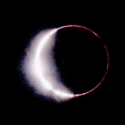
19:05:16 UT
|

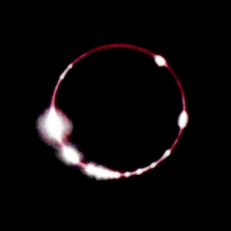
19:05:19 UT
|

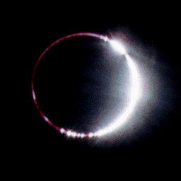
19:05:22 UT
|
CLICK
HERE for a montage of all 25 images at 3 frames/second with
explanatory notes. Or...
CLICK
HERE to view the eclipse as a QuickTime Movie. (Download
a free QuickTime viewer for Mac/Windoze from Apple).

Eastern Limb at 19:05:16
UT
|

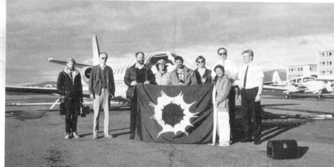
The "gang of 9" who were privileged to see the 3 October 1986
eclipse
(at 19:05:19 U.T) stand before their Cessna Citation II chase plane,
with
the celebratory eclipse flag (graciously on loan from Craig Small)
unfurled
after a successful venture.
READ ALL ABOUT THE 1986 ECLIPSE FLIGHT
Summary Article (from "CSC Printout")
... above article, continuation
... accompanying figures [1] and [2]
THE DEVIL IS IN THE DETAILS
HOW IMPORTANT IS
ATMOSPHERIC
REFRACTION, ANYWAY?

For most eclipses you needn't worry. For this one it was very
important.
Below are extracts from material reprinted from work I did in 1985/86,
which explain this (and the above figure).
ANNULAR/TOTAL ECLIPSE OF 3 OCTOBER 1986 -
CENTERLINE
DATA
The tables linked here give example centerline data for the
annular/total
solar eclipse of 03 October 1986 for elevations (flight altitudes) of 38000,
40000,
and 42000 feet above mean seal level.
The
data are tabulated in intervals of 30 seconds along the entire path of
totality. Data for one point, on either end of the totality
track,
are tabulated in the annular region.
The tables contain the following information:
U.T. - Universal Time of mid-eclipse for the given latitude and
longitude.
The Universal Times tabulated are for an assumed Delta-T correction of
56.0 seconds.
LONGITUDE - The geographic longitude of the shadow axis for the
tabulated
Universal Time. If a correction to the value of Delta-T employed
for the computation of these data is to be applied the new longitude
can
be found from: NEWLONG = LONGITUDE - 0.00417807(DELTAT - NEWDELTAT),
where
DELTAT and NEWDELTAT are in seconds. Tabulated longitudes were
computed
assuming a value of Delta-T of 56.0 seconds.
LATITUDE - The geographical latitude of the shadow axis for the
tabulated
Universal Time. In deriving these data the following numerical values
have
been used for the geodetic reference spheroid: Equatorial radius:
6378137
meters (IUGG, 1980 value), Flattening factor (f): 1/298.257 (IAU, 1976
value)
DUR - The duration of totality (or annularity) in seconds. The
tabulated durations are for a smooth lunar limb and do not take into
account
variations which may arise from the lunar limb profile. Note, in these
calculations the value of k is taken to be k=0.2725076 (where [k sin
pi]
is the sine of the apparent lunar semidiameter, pi is the lunar
horizontal
parallax.
WID The projected width of the lunar shadow, i.e. the length
of
the major axis of the shadow ellipse, in kilometers.
ALT The altitude of the sun above an astronomical horizon, in
degrees (or 90 degrees - the zenith distance). Note that the apparent
horizon,
if unobstructed, will be depressed for elevations above mean sea level.
ECCNTR - The eccentricity of the projected shadow ellipse.
T - T indicates a type code, 1 for
Total,
2 for annular.
These data have been corrected for the effects of atmospheric
refraction.
The correction for refraction is accomplished by effectively increasing
the observers elevation above sea level (see the Explanatory Supplement
to the A.E.N.A., page 54). In order for this to have been done,
mean
atmospheric temperature/pressure profiles had to be adopted. The
profiles employed were derived from observations compiled by Tverskoi
(1965,
see appended material).
ATMOSPHERIC TEMPERATURE/PRESSURE PROFILE
| The following table gives atmospheric refraction corrections
to derive
the apparent altitude of a celestial object above the horizon given the
observer's height above mean sea level and the unrefracted altitude of
the object.
The corrections given here are based on atmospheric
height/temperature
and height/pressure relations given by P.N. Tverskoi ("Physics of the
Atmosphere",
[translated from Russian] pub. Israel Program for Scientific
Translations
for NASA and NSF, 1965, p.57). The atmospheric data taken from this
source
are reproduced below in the original units (km, degrees K, and mm) and
in converted units (feet, degrees C, and millibars).
Temperature and Pressure of The Atmosphere (from Tverskoi,
1965)
km °K mm feet °C mbars
0 294 757.0 0 21 1070.0
2 278 598.0 6562 5 845.3
4 261 466.0 13123 -12 658.7
6 247 358.0 19685 -26 506.0
8 233 270.0 26247 -40 381.6
10 220 201.0 32808 -53 284.1
12 217 149.0 39370 -56 210.6
16 215 79.0 52493 -58 111.7
20 216 41.9 65617 -57 59.2
The refraction correction table gives the correction, in minutes
of arc, to be applied to the unrefracted altitude of the object, in
degrees,
given the observers height above MSL. The table is tabulated for
observer
heights in the range of 0 to 50000 feet in 1000 foot increments, and
object
altitudes of 0 to 10 degrees in increments of 0.5 degrees. Temperatures
and pressures for the refraction model at each observer height were
obtained
by a cubical spline fit to the above table. The direction of the
correction
is toward the zenith.
|
Tables of Atmospheric Refraction
Corrections
in arc minutes Toward Zenith - 0-50,000 feet, 0°-10°.
Atmospheric Refraction Correction Table
Observers Height Above MSL vs. Unrefracted Altitude Above Horizon
Corrections in Arc-Minutes Toward the Zenith
HEIGH   TEMP PRESS ------ OBJECT ALTITUDE ABOVE HORIZON IN DEGREES -------
Feet    DegC mbars   0.0  0.5  1.0  1.5  2.0  2.5  3.0  3.5  4.0  4.5  5.0
-----   ---- ------ ---- ---- ---- ---- ---- ---- ---- ---- ---- ---- ----
0       21.0 1070.0 34.8 29.0 24.6 21.2 18.5 16.3 14.6 13.1 11.9 10.9 10.0
1000    18.6 1034.5 33.9 28.3 24.0 20.6 18.0 15.9 14.2 12.8 11.6 10.6  9.7
2000    16.3  999.2 33.0 27.5 23.3 20.1 17.5 15.5 13.8 12.4 11.3 10.3  9.5
3000    13.9  964.3 32.1 26.8 22.7 19.6 17.1 15.1 13.4 12.1 11.0 10.0  9.2
4000    11.4  929.8 31.3 26.1 22.1 19.0 16.6 14.7 13.1 11.8 10.7  9.8  9.0
5000     9.0  896.1 30.4 25.3 21.5 18.5 16.1 14.2 12.7 11.4 10.4  9.5  8.7
6000     6.4  863.3 29.5 24.6 20.9 18.0 15.7 13.9 12.4 11.1 10.1  9.2  8.5
7000     3.9  831.5 28.7 23.9 20.3 17.5 15.2 13.5 12.0 10.8  9.8  9.0  8.2
8000     1.2  800.8 27.9 23.3 19.7 17.0 14.8 13.1 11.7 10.5  9.5  8.7  8.0
9000    -1.4  771.1 27.2 22.6 19.2 16.5 14.4 12.7 11.4 10.2  9.3  8.5  7.8
10000   -4.1  742.5 26.4 22.0 18.7 16.1 14.0 12.4 11.0  9.9  9.0  8.2  7.6
11000   -6.7  714.8 25.7 21.4 18.1 15.6 13.6 12.0 10.7  9.7  8.8  8.0  7.4
12000   -9.2  687.9 24.9 20.8 17.6 15.2 13.2 11.7 10.4  9.4  8.5  7.8  7.2
13000  -11.7  661.8 24.2 20.2 17.1 14.7 12.9 11.4 10.1  9.1  8.3  7.6  7.0
14000  -14.0  636.5 23.5 19.6 16.6 14.3 12.5 11.0  9.8  8.9  8.0  7.3  6.7
15000  -16.3  611.9 22.8 19.0 16.1 13.9 12.1 10.7  9.5  8.6  7.8  7.1  6.5
16000  -18.4  588.0 22.1 18.4 15.6 13.4 11.7 10.4  9.2  8.3  7.5  6.9  6.3
17000  -20.5  564.8 21.4 17.8 15.1 13.0 11.4 10.0  8.9  8.1  7.3  6.7  6.1
18000  -22.6  542.3 20.7 17.3 14.6 12.6 11.0  9.7  8.7  7.8  7.1  6.5  5.9
19000  -24.6  520.6 20.0 16.7 14.2 12.2 10.6  9.4  8.4  7.5  6.8  6.3  5.8
20000  -26.6  499.5 19.4 16.2 13.7 11.8 10.3  9.1  8.1  7.3  6.6  6.1  5.6
21000  -28.7  479.0 18.8 15.6 13.2 11.4 10.0  8.8  7.8  7.1  6.4  5.9  5.4
22000  -30.8  459.2 18.1 15.1 12.8 11.0  9.6  8.5  7.6  6.8  6.2  5.7  5.2
23000  -32.9  440.1 17.5 14.6 12.4 10.7  9.3  8.2  7.3  6.6  6.0  5.5  5.0
24000  -35.0  421.5 16.9 14.1 12.0 10.3  9.0  7.9  7.1  6.4  5.8  5.3  4.9
25000  -37.2  403.4 16.4 13.6 11.6 10.0  8.7  7.7  6.8  6.2  5.6  5.1  4.7
26000  -39.4  385.9 15.8 13.2 11.2  9.6  8.4  7.4  6.6  6.0  5.4  4.9  4.5
27000  -41.7  368.9 15.3 12.7 10.8  9.3  8.1  7.2  6.4  5.7  5.2  4.8  4.4
28000  -44.0  352.4 14.7 12.3 10.4  9.0  7.8  6.9  6.2  5.5  5.0  4.6  4.2
29000  -46.3  336.6 14.2 11.8 10.0  8.6  7.5  6.7  5.9  5.3  4.9  4.4  4.1
30000  -48.4  321.5 13.7 11.4  9.7  8.3  7.3  6.4  5.7  5.2  4.7  4.3  3.9
31000  -50.3  307.3 13.2 11.0  9.3  8.0  7.0  6.2  5.5  5.0  4.5  4.1  3.8
32000  -51.9  294.1 12.7 10.6  9.0  7.7  6.8  6.0  5.3  4.8  4.3  4.0  3.7
33000  -53.2  281.9 12.3 10.2  8.7  7.5  6.5  5.7  5.1  4.6  4.2  3.8  3.5
34000  -54.2  270.7 11.8  9.9  8.4  7.2  6.3  5.5  4.9  4.5  4.0  3.7  3.4
35000  -54.8  260.1 11.4  9.5  8.1  6.9  6.1  5.3  4.8  4.3  3.9  3.6  3.3
36000  -55.3  249.8 11.0  9.1  7.8  6.7  5.8  5.1  4.6  4.1  3.7  3.4  3.1
37000  -55.5  239.2 10.5  8.8  7.4  6.4  5.6  4.9  4.4  4.0  3.6  3.3  3.0
38000  -55.7  227.9 10.0  8.4  7.1  6.1  5.3  4.7  4.2  3.8  3.4  3.1  2.9
39000  -55.9  215.5  9.5  7.9  8.7  5.8  5.0  4.5  4.0  3.6  3.2  3.0  2.7
40000  -56.1  206.2  9.1  7.6  6.4  5.5  4.8  4.3  3.8  3.4  3.1  2.8  2.6
41000  -56.2  199.0  8.8  7.3  6.2  5.3  4.7  4.1  3.7  3.3  3.0  2.7  2.5
42000  -56.4  191.4  8.5  7.0  6.0  5.1  4.5  4.0  3.5  3.2  2.9  2.6  2.4
43000  -56.6  183.7  8.1  6.8  5.7  4.9  4.3  3.8  3.4  3.1  2.8  2.5  2.3
44000  -56.7  175.7  7.8  6.5  5.5  4.7  4.1  3.6  3.3  2.9  2.7  2.4  2.2
45000  -56.9  167.7  7.4  6.2  5.2  4.5  3.9  3.5  3.1  2.8  2.5  2.3  2.1
46000  -57.1  159.6  7.1  5.9  5.0  4.3  3.8  3.3  3.0  2.7  2.4  2.2  2.0
47000  -57.3  151.6  6.7  5.6  4.7  4.1  3.6  3.2  2.8  2.5  2.3  2.1  1.9
48000  -57.5  143.7  6.4  5.3  4.5  3.9  3.4  3.0  2.7  2.4  2.2  2.0  1.8
49000  -57.6  136.0  6.0  5.0  4.3  3.7  3.2  2.8  2.5  2.3  2.1  1.9  1.7
50000  -57.8  128.6  5.7  4.8  4.0  3.5  3.0  2.7  2.4  2.2  2.0  1.8  1.6
|
HEIGH   TEMP PRESS --- OBJECT ALTITUDE ABOVE HORIZON IN DEGREES -----
Feet    DegC mbars   5.5  6.0  6.5  7.0  7.5  8.0  8.5  9.0  9.5 10.0
-----   ---- ------ ---- ---- ---- ---- ---- ---- ---- ---- ---- ----
    0   21.0 1070.0  9.2  8.6  8.0  7.5  7.0  6.6  6.3  5.9  5.7  5.4
 1000   18.6 1034.5  9.0  8.4  7.8  7.3  6.9  6.5  6.1  5.8  5.5  5.2
 2000   16.3  999.2  8.8  8.1  7.6  7.1  6.7  6.3  6.0  5.6  5.4  5.1
 3000   13.9  964.3  8.5  7.9  7.4  6.9  6.5  6.1  5.8  5.5  5.2  5.0
 4000   11.4  929.8  8.3  7.7  7.2  6.7  6.3  6.0  5.6  5.3  5.1  4.8
 5000    9.0  896.1  8.1  7.5  7.0  6.5  6.1  5.8  5.5  5.2  4.9  4.7
 6000    6.4  863.3  7.8  7.3  6.8  6.4  6.0  5.6  5.3  5.0  4.8  4.6
 7000    3.9  831.5  7.6  7.1  6.6  6.2  5.8  5.5  5.2  4.9  4.7  4.4
 8000    1.2  800.8  7.4  6.9  6.4  6.0  5.6  5.3  5.0  4.8  4.5  4.3
 9000   -1.4  771.1  7.2  6.7  6.2  5.8  5.5  5.2  4.9  4.6  4.4  4.2
10000   -4.1  742.5  7.0  6.5  6.1  5.7  5.3  5.0  4.8  4.5  4.3  4.1
11000   -6.7  714.8  6.8  6.3  5.9  5.5  5.2  4.9  4.6  4.4  4.2  4.0
12000   -9.2  687.9  6.6  6.1  5.7  5.4  5.0  4.8  4.5  4.3  4.0  3.9
13000  -11.7  661.8  6.4  6.0  5.6  5.2  4.9  4.6  4.4  4.1  3.9  3.7
14000  -14.0  636.5  6.2  5.8  5.4  5.1  4.8  4.5  4.2  4.0  3.8  3.6
15000  -16.3  611.9  6.0  5.6  5.2  4.9  4.6  4.3  4.1  3.9  3.7  3.5
16000  -18.4  588.0  5.9  5.4  5.1  4.8  4.5  4.2  4.0  3.8  3.6  3.4
17000  -20.5  564.8  5.7  5.3  4.9  4.6  4.3  4.1  3.9  3.7  3.5  3.3
18000  -22.6  542.3  5.5  5.1  4.8  4.5  4.2  3.9  3.7  3.5  3.4  3.2
19000  -24.6  520.6  5.3  4.9  4.6  4.3  4.1  3.8  3.6  3.4  3.3  3.1
20000  -26.6  499.5  5.1  4.8  4.5  4.2  3.9  3.7  3.5  3.3  3.1  3.0
21000  -28.7  479.0  5.0  4.6  4.3  4.0  3.8  3.6  3.4  3.2  3.0  2.9
22000  -30.8  459.2  4.8  4.5  4.2  3.9  3.7  3.5  3.3  3.1  2.9  2.8
23000  -32.9  440.1  4.6  4.3  4.0  3.8  3.5  3.3  3.2  3.0  2.8  2.7
24000  -35.0  421.5  4.5  4.2  3.9  3.6  3.4  3.2  3.1  2.9  2.7  2.6
25000  -37.2  403.4  4.3  4.0  3.8  3.5  3.3  3.1  2.9  2.8  2.7  2.5
26000  -39.4  385.9  4.2  3.9  3.6  3.4  3.2  3.0  2.8  2.7  2.6  2.4
27000  -41.7  368.9  4.0  3.8  3.5  3.3  3.1  2.9  2.7  2.6  2.5  2.4
28000  -44.0  352.4  3.9  3.6  3.4  3.2  3.0  2.8  2.7  2.5  2.4  2.3
29000  -46.3  336.6  3.8  3.5  3.3  3.1  2.9  2.7  2.6  2.4  2.3  2.2
30000  -48.4  321.5  3.6  3.4  3.1  2.9  2.8  2.6  2.5  2.3  2.2  2.1
31000  -50.3  307.3  3.5  3.3  3.0  2.8  2.7  2.5  2.4  2.3  2.1  2.0
32000  -51.9  294.1  3.4  3.1  2.9  2.7  2.6  2.4  2.3  2.2  2.1  2.0
33000  -53.2  281.9  3.3  3.0  2.8  2.6  2.5  2.3  2.2  2.1  2.0  1.9
34000  -54.2  270.7  3.1  2.9  2.7  2.5  2.4  2.3  2.1  2.0  1.9  1.8
35000  -54.8  260.1  3.0  2.8  2.6  2.5  2.3  2.2  2.1  1.9  1.9  1.8
36000  -55.3  249.8  2.9  2.7  2.5  2.4  2.2  2.1  2.0  1.9  1.8  1.7
37000  -55.5  239.2  2.8  2.6  2.4  2.3  2.1  2.0  1.9  1.8  1.7  1.6
38000  -55.7  227.9  2.7  2.5  2.3  2.2  2.0  1.9  1.8  1.7  1.6  1.6
39000  -55.9  215.5  2.5  2.3  2.2  2.0  1.9  1.8  1.7  1.6  1.5  1.5
40000  -56.1  206.2  2.4  2.2  2.1  2.0  1.8  1.7  1.6  1.6  1.5  1.4
41000  -56.2  199.0  2.3  2.2  2.0  1.9  1.8  1.7  1.6  1.5  1.4  1.4
42000  -56.4  191.4  2.2  2.1  1.9  1.8  1.7  1.6  1.5  1.4  1.4  1.3
43000  -56.6  183.7  2.2  2.0  1.9  1.7  1.6  1.5  1.5  1.4  1.3  1.3
44000  -56.7  175.7  2.1  1.9  1.8  1.7  1.6  1.5  1.4  1.3  1.3  1.2
45000  -56.9  167.7  2.0  1.8  1.7  1.6  1.5  1.4  1.3  1.3  1.2  1.1
46000  -57.1  159.6  1.9  1.7  1.6  1.5  1.4  1.3  1.3  1.2  1.1  1.1
47000  -57.3  151.6  1.8  1.7  1.5  1.4  1.4  1.3  1.2  1.1  1.1  1.0
48000  -57.5  143.7  1.7  1.6  1.5  1.4  1.3  1.2  1.1  1.1  1.0  1.0
49000  -57.6  136.0  1.6  1.5  1.4  1.3  1.2  1.2  1.1  1.0  1.0  0.9
50000  -57.8  128.6  1.5  1.4  1.3  1.2  1.2  1.1  1.0  1.0  0.9  0.9
|
The temperatures and pressures assumed for the tracks, at the
tabulated
elevations, were obtained from a cubicle spline fit to these profiles.
The degree of refraction, as a function of zenith distance,
was
computed as the ratio of two truncated power series parameterized by
the
pressure and temperature at a given elevation. (See the 1987
Astronomical
Almanac, page B62). This was compared to the degree of refraction
at sea level, to derive an effective refractive index for the
airpath.
From this, the observers effective elevation was derived (see
Chauvenet,
Vol. 1, p. 516).
CENTERLINE TRACKS
The centerline tracks for the 03 October 1986 eclipse, for the
tabulated
elevations above mean sea level (38000, 40000 and 42000 feet), are
depicted
on the accompanying orthographic projection map. The leftmost of
the three roughly parallel curves is the centerline at 42000 feet, the
center curve corresponds to an elevation of 40000 feet and the
rightmost
38000 feet.
The centerlines run, in Universal Time, from 18h55m to 19hl6m.
This completely covers the path of totality, but includes only a short
segment of the path of annularity at the ends of the curves. Time
tics for each minute of Universal Time are shown on the map.
The coordinates of the points plotted on the eclipse map are taken
from
the tabulated centerline data.
Correcting for both the aircraft altitude, and atmospheric
refraction
at 3 different altitudes, the centerline tracks for 18:55UT- 19:16-UT
were
as follows:

Or, in a bit more detail, with a change in altitude of 12,000 feet
the
path shifts, even at maximum eclipse, by more than its width.

For this eclipse it was CRITICAL to be centrally located within the
limb-corrected shadow.
LIMB PROFILE
Alan Fiala (USNO) kindly provided us with a prediction of the limb
profile for 19:06 and 19:07 U.T. from sea level. As can be
seen,
the topocentric prediction indicated incomplete photospheric
extinction.
Compare the morphology of the limb features in this prediction with
the photograph above taken at 19:05:19 UT. Though our mid-eclipse
intercept was 40 seconds earlier than the time of first limb
prediction,
the topocentric librational differences are insignificant. Looks
like within the systematic uncertainties, we nailed it.
And, What Did The Icelandic Newspaper, the MORGUNBLADID, have to
say about this?
Well, if you can read THIS let me
know!
Glenn
Schneider


