A Flight into The Darkness of the Lunar Umbral Shadow
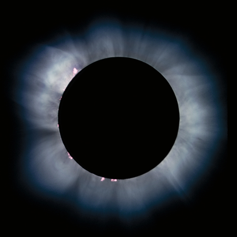
2m 55.9s (+/-10s) of Totality
From the Pristine, Clear, and Particulate Free Skies
of the High Polar (latitude = +82.6°) North from 37,000 feet
Launched from Dusseldorf, Germany
with "Flightseeing" of the North Pole and Svalbard
A COLLABORATIVE ADVENTURE OFFERED BY:
| LTU/Airberlin Airlines | Deutsche Polarflug | Sky & Telescope | TravelQuest International |
| Eclipse Flight
Technical Planning by Dr.
Glenn Schneider, Steward Observatory, University of Arizona |
|||
Click HERE for Frequently Asked Questions About the TSE2008 Flight
TSE2008 AND
AN OPPORTUNITY FOR AIRBORNE OBSERVATIONS
The next total solar eclipse
visible
from the Earth will occur on 01 August 2008. The path of
totality, the region on the Earth's surface where the Sun will be
totally obscured by the Moon, begins in northern Canada. There,
interrupting the otherwise leisurely brightening of the polar sky at
local sunrise at 09:24 UT, darkness will rapidly descend as the lunar
umbral shadow touches down on the surface of the Earth. The
Moon's shadow then quickly whisks northeastward over the Canadian
Arctic, the north
coast of Greenland and the Arctic
Ocean. Due north of Iceland, the centerline of the totality path
approaches within 7
degrees of latitude of the North Pole. With the shadow decelerating,
path of totality then turns southward,
passing between Svalbard (Norway) and
Novaya Zemlya (Russia). After traversing across northern Russia,
accelerating again after local noon
and cutting a swath through Siberia, the total eclipse
will end in central China as the Moon's shadow
lifts back into space at local sunset at 11:21 UT. For a span
three hours the trek of the lunar shadow will plunge isolated regions
of the Earth into darkness, but for no more then 2m 27s from any
location (on the ground). This, the total solar eclipse of
01 August 2008 (TSE2008) is now very much on the minds of eclipse
"chasers" world-wide, will be observed from 37,000 ft. above the Arctic
Ocean only 7.4 degrees from the North Pole.

01 August 2008 Total Solar Eclipse -- Path of Totality
(The TSE2008 flight will observe totality at the location indicated by the green dot.)
Eclipse chasers have weighed the available options (and risks) of ground-based expeditions to conduct observations in northern Canada, Greenland, Siberia, or north-western/central China. The prospects for clear skies over northern Canada/Greenland are bleak and accessibility to the path, while (in some places) possible, is difficult but the altitude of the Sun is low where an infrastructure exists to enable travel to/from potential eclipse sites. Path accessibility and cloud cover expectations are similarly daunting over northern Russia and most of Siberia. This situation is similar to that of 23 November 2003 total solar eclipse (TSE2003) - which was visible only from the Antarctic, but was successfully observed by two well-planned flights over the inland regions of the "White Continent" using Boeing 747-400ER (Qantas) and Airbus A340 (Lan Chile) aircraft. A similar airborne option for TSE2008 has been arranged for the eclipse chasing community of professional and amateur astronomers, and other "umbraphiles".
Unlike TSE2003, other less logistically challenging observation options for TSE2008 exist, but with mixed elements of risk for expectation of cloud cover, and difficulty for access in the regions which have the highest statistical probabilities for clear skies. In particular, south eastward of the (high cloud-cover probability) "local noon" point on centerline, the path of totality crosses over Novosibirsk - a readily accessible major city in Siberia - and a likely destination for many more casual eclipse chasers due to its ease of access and convenience it affords. The likelihood of seeing the eclipse from Novosibirsk and its environs, however, is only about 50% based upon prevailing cloud conditions at that time of year. The cloud cover situation improves as the path moves into China, considerably better where the altitude of the Sun is (unfortunately) declining toward sunset. Accessibility to centerline in the "best" regions in China (near Mongolia) is more difficult and mobility (in reaction to unfavorable weather conditions) along the path of totality is questionable, and higher-airmass along the line-of-site near sunset much less appealing.
At this altitude and latitude, aerosol scattering of sunlight by airborne particulates is extremely low, giving rise to an exceptionally dark sky during totality, enabling eclipse viewing with significantly enhanced image contrasts. Moreover, the airmass along the line-of-sight to the Sun is significantly reduced (by ~ 75%), resulting in exceptional sky transparency, greatly reduced atmospheric turbidity, and better astronomical "seeing".
THE "CLOSE" VIEW FROM ON HIGH
The TSE2008 eclipse flight will have a duration of 12 hours,
inclusive of the "flightseeing" segments over Svalbard and the
geographic North Pole (90°N). The formulation and details of
a "baseline"
flight plan, with a provisional timeline is provided below, but in
detail
is
subject to revision based upon actual flight conditions. We
remain
flexible to in-flight adaptation, as required, to assure an optimal
eclipse intercept. 01 August 2008 Total Solar Eclipse -- Path of Totality
(The TSE2008 flight will observe totality at the location indicated by the green dot.)
Eclipse chasers have weighed the available options (and risks) of ground-based expeditions to conduct observations in northern Canada, Greenland, Siberia, or north-western/central China. The prospects for clear skies over northern Canada/Greenland are bleak and accessibility to the path, while (in some places) possible, is difficult but the altitude of the Sun is low where an infrastructure exists to enable travel to/from potential eclipse sites. Path accessibility and cloud cover expectations are similarly daunting over northern Russia and most of Siberia. This situation is similar to that of 23 November 2003 total solar eclipse (TSE2003) - which was visible only from the Antarctic, but was successfully observed by two well-planned flights over the inland regions of the "White Continent" using Boeing 747-400ER (Qantas) and Airbus A340 (Lan Chile) aircraft. A similar airborne option for TSE2008 has been arranged for the eclipse chasing community of professional and amateur astronomers, and other "umbraphiles".
Unlike TSE2003, other less logistically challenging observation options for TSE2008 exist, but with mixed elements of risk for expectation of cloud cover, and difficulty for access in the regions which have the highest statistical probabilities for clear skies. In particular, south eastward of the (high cloud-cover probability) "local noon" point on centerline, the path of totality crosses over Novosibirsk - a readily accessible major city in Siberia - and a likely destination for many more casual eclipse chasers due to its ease of access and convenience it affords. The likelihood of seeing the eclipse from Novosibirsk and its environs, however, is only about 50% based upon prevailing cloud conditions at that time of year. The cloud cover situation improves as the path moves into China, considerably better where the altitude of the Sun is (unfortunately) declining toward sunset. Accessibility to centerline in the "best" regions in China (near Mongolia) is more difficult and mobility (in reaction to unfavorable weather conditions) along the path of totality is questionable, and higher-airmass along the line-of-site near sunset much less appealing.
TOP 10 REASONS FOR A POLAR STRATOSPHERIC
ECLIPSE FLIGHT
| DEPLOYMENT/RELOCATION FLEXIBILITY To Find the BEST Spot in the Area of Operations for Observing |
CLOUD OBSCURATION AVOIDANCE Polar Summer Stratosphere: 99.99% -- Virtually Assured |
| TOTALITY PROLONGATION Aircraft Speed Extends the Duration of Totality |
SKY TRANSPARENCY Significantly Improved -- Low Particulate Scattering |
| SKY DARKNESS Much Higher Contrast Coronal Visibility and to Larger Distance |
IMPROVED ASTRONOMICAL SEEING "r_naugh" Decreases with Increasing Altitude |
| REDUCED ATMOSPHERIC TURBIDITY Vorticity & Sheer Decline in Power Above Tropopause |
PANCHROMATIC
VISIBILITY IR and UV "Windows" Open Up or are Extended |
| UNPARALLELED HORIZON REACH &
OBSERVATION VISTA Apparent horizon 377 km distant, depressed 3.4° (at 37,000 ft) |
ESTHETIC, ETHEREAL EXPERIENCE There is nothing quite like it... |
FLIGHT PLAN  (click graphic to see at 2x) Black line is the outbound baseline plan. Red dashed are representative contingency alternates. |
TSE2008
is the perfect total solar eclipse for viewing from an airborne venue
aboard a high
altitude jet aircraft that removes the usual meteorological
risks and logistical uncertainties which plague eclipse-chasers. From
the high polar north, just 7°
from the North geographic Pole, TSE2008 will be observed from the
pristine,
dark, and cloud-free skies 37,000 ft. above sea level. Flying above 3/4ths
of the
Earth's
otherwise murky atmosphere, at Mach 0.85, the duration
of totality will be extended to ~ 2m 56s (+/- ~10s ; depending upon the
final chosen point of mid-eclipse intercept and winds-aloft during the
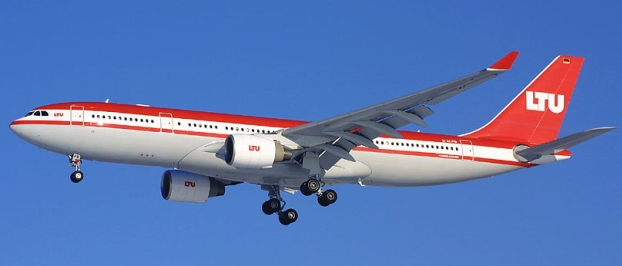
"totality run"). For TSE2008 will launch launch a dedicated, round-trip, and non-stop eclipse observation flight from the Dusseldorf (Germany) International Airport, a major, and easily accessible, airport in central Europe, with the value-added attractions of pre- and post- totality overflights of Longyearbyen/Svalbard and of the North geographic pole. Our 12-hour flight will launch at Germany at 0400 UT (6 AM local time) on 01 August 2008 and take to the sky with an LTU/Airberlin A330-200 aircraft on a dedicated mission to centrally intercept the Moon's fleeting shadow as it whisks across the Arctic Ocean. Flying northward from Germany, in route to the path of totality, we will descend to low-altitude for a unique "flightseeing" opportunity over Longyearbyen and other points of interest on and around the island of Svalbard. We will then cruise onward to our precision rendezvous with the Moon's shadow. After totality, we will overfly and circumnavigate the geographic North Pole before turning southward for our return leg to Dusseldorf. Planning and preparation for this event has been on-going for more than two years, predicated on our uncompromisingly successful previous eclipse flights. The myriad of details associated with the TSE2008 flight concept has been fully explored, and the plan that has emerged ready for execution on 01 August 2008 is presented here. As TSE2008 is nearly upon us, any with interest in participating should inquire ASAP, as available windows on the sun-side of the aircraft are rapidly vanishing. |
THE "WEATHER"
(acuna matata)
At high polar latitudes, such as at our 82.6° N
point of
mid-eclipse intercept, the tropopausal boundary between the troposphere
below (where "weather occurs") and the
stratosphere has typical heights of only 6—9 km (compared to 12—17 km
at mid
and low latitudes). Polar stratospheric (nacrecous) clouds are extremely rare and only form at
very
low temperatures (< -78° C) during the polar winter, making the
probability of cloud-free eclipse viewing nearly 100% at our flight
altitude of 37,000 ft (~11.3 km) and "baseline" observing
location. Of course, we have the luxury (and flexibility) for in
situ retargeting of our viewing location if that is required for any
reason, however unlikely. At this altitude and latitude, aerosol scattering of sunlight by airborne particulates is extremely low, giving rise to an exceptionally dark sky during totality, enabling eclipse viewing with significantly enhanced image contrasts. Moreover, the airmass along the line-of-sight to the Sun is significantly reduced (by ~ 75%), resulting in exceptional sky transparency, greatly reduced atmospheric turbidity, and better astronomical "seeing".
THE "BIG" VIEW
FROM ON HIGH
IN THE MOON'S SHADOW AT 35.000
FEET
 |
The view of a total solar eclipse, and the sweep of the Moon's umbral shadow as it races across (and above) the Earth as seen from such a lofty height, is magnificent. As seen from 37,000 feet above the surface of the Earth, the apparent horizon is 377 km (234 miles) away and depressed by 3.4° compared to sea level. As shown in the accompanying photographs (top by C. Roberts ~ 1 minute before and after totality, bottom by J. Pasachoff at mid-eclipse) taken from the 23 November 2003 eclipse flight at 35,000 feet at a latitude of 70° S: — The high reflectivity of the polar ice below accentuates the stark contrast between the eclipse-darkened regions within umbral shadow, and those illuminated by the Sun beyond the shadow's periphery. — Looking along the apex of the lunar umbral cone, toward the eclipsed Sun at mid-totality, the curvature of the distant umbral shadow boundary (i.e., the "shadow ellipse") is readily apparent. The 01 August 2008 Arctic/polar eclipse flight provides an unparalleled opportunity to observe the upcoming eclipse under the very favorable, and remarkably similar, conditions as prevailed for the 23 November 2003 Antarctic eclipse flight. For TSE2008 the Sun will be at a somewhat higher altitude, 25° above the horizon vs. 15° (as in these photographs), and the eclipse will be viewed closer to the Earth's rotational pole than any total solar eclipse in history. |
THE "CLOSE" VIEW FROM ON HIGH
This, likely, is the most frequently asked question from those with ground-based eclipse observing experience. The answer (in an aircraft with suitable windows) is unequivocally YES. This was recently demonstrated with spectacular results from images taken by D. Finally (an eclipse-viewing passenger on the 23 November 2003 QF2901 Antarctic eclipse flight) through one of the main cabin windows as processed by M. Druckmuller (see image to right). The 22x32 cm cabin windows of the Airbus A330-200 aircraft have been inspected and are of good optical quality and equally well suited for eclipse observations. Our aircraft provider (LTU/Airberlin) is well aware of the cleanliness requirements for the windows on the TSE2008 flight, and will deliver the aircraft for preparation to our detailed specifications the evening before the eclipse. The placement and cadence of the windows with respect to each of the two-seat sun-side seat rows has been checked for accessibility from the adjacent seats (the few seat rows without suitable window access will not be used). Individuals can assess (from inspection photographs on the TravelQuest web site which are available) whether share or exclusive window access suits their needs. |
"Can I really observe coronal detail through an airplane window?"  |
WHY ARE WE
FLIGHTSEEING IN ADDITION TO SEEING THE ECLIPSE?
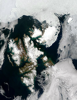 SVALBARD |
The
likelihood of a delayed take-off from Dusseldorf at 6 AM in
the
morning is exceedingly small. None-the-less, the eclipse intercept has
not been planned with a time-critical take-off. The
inclusion of "extra" time aloft, before the time-critical intercept
with the Moon's shadow, is a necessary
and prudent contingency to safeguard against the unlikely event of a
take-off delay. In doing so we make the most
effective use
of requisite contingency scheduling "dead time" by augmenting the
flight plan with spectacular value-added sightseeing opportunities over
these geographically fascinating terrains. These "flightseeing" segments are not specifically tied to the eclipse observations. The flight plan is baselined with pre-eclipse low-altitude flightseeing segments over Longyearbyen/Svalbard and a post-eclipse fly-over and circumnavigation of the geographic North Pole. Click HERE to see the flight plan segment ordering that allows us to use the approximately an hour of pre-planned low-altitude (7,000 ft.) flightseeing time as a buffer against a "late" take-off and still achieve an optimized mid-eclipse intercept. One, or both, of the flightseeing segments could be executed following the "totality run", if that contingency should prove necessary. |
 NORTH POLE |
IN FLIGHT
ADAPTABILITY FOR SUCCESS
The final determination of the eclipse intercept point will be predicated upon actual flight conditions to maximize the viewing opportunities for all on-board participants. All things being equal we will select a point to maximize the duration of totality without compromising the view of the eclipse from any of the sun-side windows. We are provisionally targeting for a mid-eclipse intercept of 09:43 UT where the in-flight duration of totality will be 2m 56s. Within our area of operations of durations of totality are 2m 52s +/-10s.
The detailed pre-planning of the observation-optimized eclipse flight, and the ability to respond to changing in-flight conditions in situ, have been made possible by the development, and well-tested use, of a special software package, EFLIGHT, designed for specifically that purpose. EFLIGHT, and its core astrodynamical and navigational algorithms, have been used to plan six and execute four solar eclipse flights (most recently executed for the Antarctic eclipse flights previously mentioned -- see HERE for more details).
WHERE WILL WE
VIEW TOTALITY?
The pre-selected point of mid-eclipse intercept for the "totality run" was arrived at based upon a number of competing criteria.
1.
Totality Duration. For clarity
of discussion, it is the TOTAL phase of the solar eclipse (i.e.,
"totality"), when the Moon completely covers the Sun, which is of
paramount interest - and importance. Totality is fleetingly
short. On the ground, the maximum duration of TSE2008 will be 2m
27s. This longest possible duration would be experienced by an
observer centrally located within the
Moon's shadow (i.e., on "centerline") where the projection of the
shadow on the rotating Earth is moving (relatively) most slowly
(in northern Russia). Elsewhere along and across the path of
totality, the duration of the total phase of the eclipse is
diminished. Every second of totality is precious to eclipse
chasers, and a high-priority goal is to maximize the achievable
duration of totality. From the ground, that goal is weighed against the
risks imposed by weather, and logistical constraints. If weather and
accessibility were not issues, ground-based eclipse observers would all
cluster at the one point in the path where totality was longest.
From the air (with sufficient aircraft endurance), and as clouds
are almost assuredly not an issue, this too would be the dominant
factor in selecting the point of "mid-eclipse intercept" (the place at
which the aircraft will be centrally located within the Moon's umbral
shadow at mid-totality). Maximizing the achievable duration of
totality remains a goal against which other factors are weighed, but
additional constraints must be considered.
2. Solar Elevation Constraint. In selecting the geographic (topocentric) location for an airborne "mid-eclipse intercept", the altitude of the Sun (above the horizon) cannot be so high as to make window-viewing impractical. Unfortunately, longer achievable durations of totality are (typically) correlated with higher Solar elevations. This is a trade which must be made, and solar elevations of 30 degrees or more must be excluded. Conversely, the Sun must be sufficiently above the horizon to (a) maximize the sky clarity, (b) circumvent obscuration by aircraft wing dihedral, (c) reduce the probability of a (distant) obscuring cloud along the line-of-site, (d) provide a darker sky background and better viewing contrast during totality. (At a minimum the Sun should be at least 7 degrees above the horizon, but we establish 10 degrees as a working minimum, but other constraints place the Sun higher in the sky for the TSE2008 flight). Consideration is also given to a maximum elevation constraint to enable the most effective use of window-sharing possibilities - though the maximum elevation is also bounded by item (6) below.
3. Aircraft Heading Constraint. The azimuth angle of the Sun, as seen from the chosen point of mid-eclipse intercept, constrains the heading of the aircraft. For optimal viewing of the eclipse out the windows, the heading of the aircraft should be orthogonal to the Solar azimuth at mid-eclipse. I.e., the Sun should be (close to) "straight out" the Sun-side passenger cabin windows. Such aircraft orientations, unfortunately, are not in the direction of motion of the Moon's shadow for nearly all locations along the path of totality. From the air, the achievable duration of totality (for a given mid-eclipse intercept location) is modified by the aircraft's velocity vector and would be maximized by flying, instantaneously, in the direction of the velocity vector of the lunar shadow. For points of mid-eclipse intercept under consideration, a fully duration-optimized heading would displace the azimuthal viewing angle to the Sun significantly, and make window viewing difficult, if not impossible. Within the region of the path of totality constrained by the 10 to 30 degree solar elevation constraint, the aircraft must fly a heading which "crosses" the centerline of totality at mid-eclipse, to maintain solar visibility from the cabin windows. Flying at the necessary specific heading with the Sun out the starboard side windows would still yield a net increase in the duration of totality compared to a groundbased observer, as a component of the aircraft velocity vector would be in the direction of the Moon's.
4. Achievable Totality Duration. Figure 1 shows the duration of totality seen by a ground based observer on centerline along the path of totality with mid-eclipse times of 9h25m to 9h50m U.T. (red) compared to the duration of totality seen from an aircraft flying at ground speed of 470 NM/h at 35,000 ft. (slightly different than we are now planning), with the heading of the aircraft is equal to the solar azimuth minus 90 degrees. Note that an airborne mid-eclipse intercept, executed in this manner, at times 09:30 UT and later will result in a longer totality than can be achieved anywhere on the ground. The corresponding solar elevation, in degrees above the astronomical horizon, is show in Figure 2.
Note: As a matter
of practicality, the
eclipse must be viewed (photographed and recorded) from the passenger
cabin windows - which constrains the selection of a point of
mid-eclipse intercept.
2. Solar Elevation Constraint. In selecting the geographic (topocentric) location for an airborne "mid-eclipse intercept", the altitude of the Sun (above the horizon) cannot be so high as to make window-viewing impractical. Unfortunately, longer achievable durations of totality are (typically) correlated with higher Solar elevations. This is a trade which must be made, and solar elevations of 30 degrees or more must be excluded. Conversely, the Sun must be sufficiently above the horizon to (a) maximize the sky clarity, (b) circumvent obscuration by aircraft wing dihedral, (c) reduce the probability of a (distant) obscuring cloud along the line-of-site, (d) provide a darker sky background and better viewing contrast during totality. (At a minimum the Sun should be at least 7 degrees above the horizon, but we establish 10 degrees as a working minimum, but other constraints place the Sun higher in the sky for the TSE2008 flight). Consideration is also given to a maximum elevation constraint to enable the most effective use of window-sharing possibilities - though the maximum elevation is also bounded by item (6) below.
3. Aircraft Heading Constraint. The azimuth angle of the Sun, as seen from the chosen point of mid-eclipse intercept, constrains the heading of the aircraft. For optimal viewing of the eclipse out the windows, the heading of the aircraft should be orthogonal to the Solar azimuth at mid-eclipse. I.e., the Sun should be (close to) "straight out" the Sun-side passenger cabin windows. Such aircraft orientations, unfortunately, are not in the direction of motion of the Moon's shadow for nearly all locations along the path of totality. From the air, the achievable duration of totality (for a given mid-eclipse intercept location) is modified by the aircraft's velocity vector and would be maximized by flying, instantaneously, in the direction of the velocity vector of the lunar shadow. For points of mid-eclipse intercept under consideration, a fully duration-optimized heading would displace the azimuthal viewing angle to the Sun significantly, and make window viewing difficult, if not impossible. Within the region of the path of totality constrained by the 10 to 30 degree solar elevation constraint, the aircraft must fly a heading which "crosses" the centerline of totality at mid-eclipse, to maintain solar visibility from the cabin windows. Flying at the necessary specific heading with the Sun out the starboard side windows would still yield a net increase in the duration of totality compared to a groundbased observer, as a component of the aircraft velocity vector would be in the direction of the Moon's.
4. Achievable Totality Duration. Figure 1 shows the duration of totality seen by a ground based observer on centerline along the path of totality with mid-eclipse times of 9h25m to 9h50m U.T. (red) compared to the duration of totality seen from an aircraft flying at ground speed of 470 NM/h at 35,000 ft. (slightly different than we are now planning), with the heading of the aircraft is equal to the solar azimuth minus 90 degrees. Note that an airborne mid-eclipse intercept, executed in this manner, at times 09:30 UT and later will result in a longer totality than can be achieved anywhere on the ground. The corresponding solar elevation, in degrees above the astronomical horizon, is show in Figure 2.
| In the Area of Operations, the duration of
totality will be increased by appx. 40s over the “ground"... |
...with the Sun comfortably positioned and
optimally oriented for observations on the starboard side of the
aircraft. |
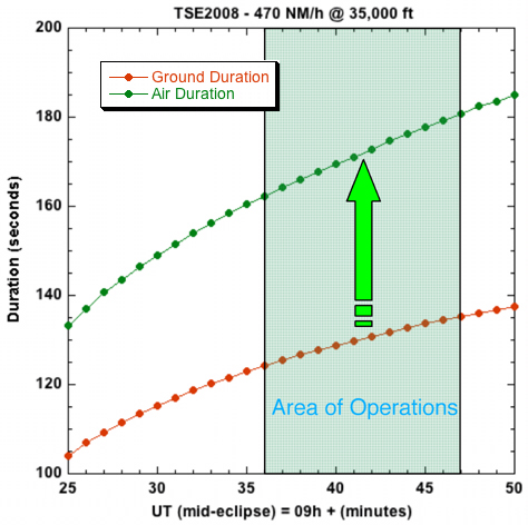 Figure 1. Ground and Air Durations of Totality |
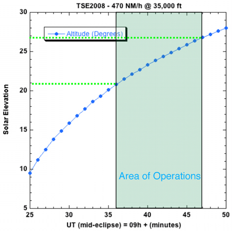 Figure 2. Solar Elevation at Mid-Eclipse Figure 2. Solar Elevation at Mid-Eclipse |
5.
Aircraft Altitude. The
location (and centerline) of the path of totality changes with aircraft
altitude, and is significantly shifted from the sea-level projection of
the Moon's shadow on the surface of the Earth. The high (10-12 km)
flight altitudes achievable by our Airbus A330-200 assure
uncompromisingly spectacular atmospheric conditions for viewing the
eclipse. The nominal service ceiling of our Airbus
A330-200 aircraft is 40,000 ft. We anticipate the a slightly a lower
altitude of 37,000 ft given the the air density/temperature
conditions at the
high polar latitude of the nominal mid-eclipse intercept and the
residual fuel weight at the time of the totality run. Our baseline
plan is to observe the eclipse from an altitude of 37,000
ft. Flight conditions permitting we will observe the eclipse from
the highest elevation achievable by the aircraft.
6. Air Space Restrictions. Operations in and near the air space of the Franz Joseph Land region of the Russian Federation is restricted. The baseline flight plan precludes intrusion into restricted airspace.
7. Take-off and Landing Constraints. Both the takeoff (no earlier than time) and landing (no later than time) are constrained by airline, civil aviation regulations, airport operations, and aircraft scheduling and availability.
THE "TOTALITY
RUN" - DESCRIPTION
The TSE2008 flight's point of
mid-eclipse
intercept is optimize by observing the
the eclipse as far east along the path of totality as possible up to
the point of "maximum eclipse", but constrained by the criteria
previously discussed. We nominally have selected a mid-eclipse
intercept corresponding to a Universal Time of mid-eclipse of 09:43 UT
at an altitude of 37.000 ft. above mean sea level.
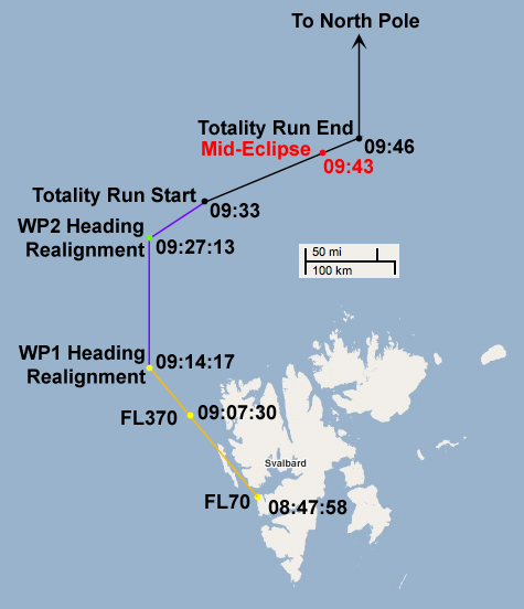 |
Following
the Spitzbergen (Svalbard) siteseeing leg, our aircraft will
climb from 7,000 ft to 37,000 ft. to a pre-positioning point (WP1) at
80°N, 5°E, 145.4 nm ground-track distance from the start of the
"Totality Run". At
that point we will execute a shallow heading alignment maneuver
designed to bring us to a point of planned mid-course correction (WP2)
44.8
nm from the start of the totality run. During this 145.4
nm of flight approaching the totality run, we will adjust the
aircraft's speed and direction of flight, as necessary, to assure a
high-precision arrival in time and space to begin the Totality Run 10
minutes before mid-eclipse. Upon arrival at the Totality Run start point, we will place the aircraft on a heading so that at Mach 0.85 (483 nm/hr) it will cross centerline (at 37,000 ft. while flying "straight and level") at the instant that the aircraft is centrally located within the footprint of the Moon's (moving) umbral shadow and, oriented so the Sun appears "straight out" the cabin windows (i.e., perpendicular to the direction of flight). Thus, the heading of the aircraft will be that of the solar azimuth at the point of mid-eclipse intercept minus 90 degrees. The Totality Run will commence prior to second contact, nominally *10* minutes before mid-eclipse (~ 8.4 minutes before second contact). Our pre-positioning leg will terminate with a small heading realignment maneuver to place the aircraft at the Totality Run Start point and at the requisite time, heading and speed so the aircraft will be centrally located in the umbral shadow at the instant of mid-eclipse. No change in aircraft heading (orientation) or altitude would be planned once the Totality Run begins. The aircraft will turn onto the Totality Run track sufficiently far ahead (in time) of second contact to allow observers to acquire the Sun in photographic equipment, and watch the last part of the partial eclipse ingress while the Sun appears as a thin crescent. Here, the completion of the heading re-alignment maneuver is planned to place the aircraft at the Totality Run "Start point" 10 minutes before mid-eclipse (appx 8m 20s minutes before second contact). The aircraft will remain on this heading for at least 3 minutes after mid-eclipse (i.e., appx 1m 35s after third contact {or longer at pilot's discretion}), before turning the due north for a post-eclipse overflight and circling of the North geographic pole. |
Over the course of the baseline
Totality Run the
aircraft will cover covering a ground track distance of 104.65 nautical
miles before turning due north for post-eclipse sitseeing of the
geographic noth pole (and possible additional discretionary sightseeing
over Svalbard in route back to Dusseldorf after that).
THE BASELINE
"TOTALITY RUNS" - POSITION AND CIRCUMSTANCES
A series representative Totality Runs, used earlier in pre-flight planning, were developed for illustrative purposes with mid-eclipse intercepts (when the aircraft is centrally located in the Moon's umbral shadow) with Universal Times of 09h 34m 53s to 09h 47m 00.0s. These differ in small details from the aadopted baseline plan which we will file with Air Traqffic Control. In these specific examples a flight altitude of 35,000 ft was used. These UT times corresponds to locations for the instants of mid-eclipse intercept from Longitudes from 32.4°W to 33.7°E, and Latitudes = 81.1°N to 83.6°N. This is between the northeast coast of Greenland and midway between Svalbard and the west coast of Franz Joseph Land (see Figure 3). Note that we have the ability to execute any of these Totality Runs, or other varients, should inflight conditions require a deviation from our nominal 37,000 ft, 04:43 UT intercept, baseline.
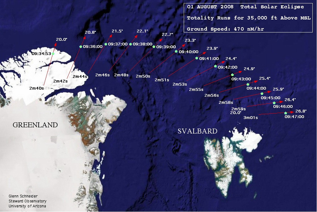
Figure 3. Representative
12-minute duration extended "Totality Runs" (red lines)
beginning 9 (rather than 10) minutes before, and ending 3 minutes after
mid-eclipse
intercepts (green points), with the aircraft located concentrically
within the Moon's
umbral shadow. In this illustration, a nominal ground
speed of 470 NM/hr (with a "no wind"
condition), flight altitude 35,000 ft. above MSL, and aircraft headings
orthogonal to the solar azimuth (azimuth + 90 degrees) are presumed.
Summary details for the specific Totality Runs illustrated in Figure 3 are given in the following table:
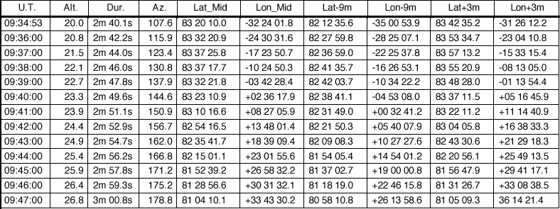
The actual totality run to be executed may vary slightly from those represented above based upon actual in flight conditions and operational constraints and restrictions. Following an initial entry corresponding to a solar elevation of 20° (over near-coastal Greenland) in the 35,000 ft elevation table above, the table lists totality runs in 1 minute equal intervals in times of mid-eclipse intercept over the Arctic Ocean to the approximate boundary of the restricted airspace of the Russian Federation. An eastern-most executed totality run would terminate with a post-totality heading alignment maneuver to assure no intrusion into restricted airspace. This might entail "shifting" the totality run, appropriately for an optimal mid-eclipse intercept, a few tens of kilometers westward to a very slightly earlier time of mid-eclipse intercept, but still in the immediate region northeast of Svalbard as shown in the figure 4.
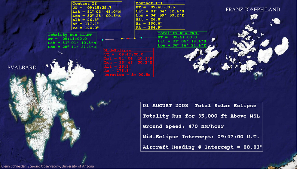
Figure 4. Details of an eastern-most 9-minute duration totality run approximately bounded by restricted airspace, giving rise to a 3m 01s duration of totality.
The above "baseline" totality
runs
are given for illustrative purposes. The actual flight-condition
optimized plan could occur at intermediate locations with mid-eclipse
intercepts along the at-altitude centerline of the path of
totality.
Currently we are planning 37,000 ft., mid-eclipse central intercept at 09:43:00 UT, and a ground speed of 483 nm/hr. which will result in the following eclipse circumstances:
TOTALITY DURATION = 2m 55.9s
SECOND CONTACT (START OF TOTALITY)
UNIVERSAL TIME = 09:41:31.9 UT
AIRCRAFT LATITUDE = 82° 31' 14.5"N
AIRCRAFT LONGITUDE = 17° 14' 43.8"E
Solar Altitude = 24.9°
Solar Azimuth = 160.1°
Position Angle of Contact = 120.0°
MID-ECLIPSE INTERCEPT:
UNIVERSAL TIME = 09:43:00 UT
LATITUDE = 82° 35' 01.6"S
LONGITUDE = 18° 40' 50.4"N
Solar Altitude = 24.9°
Solar Azimuth = 161.9°
THIRD CONTACT (END OF TOTALITY)
UNIVERSAL TIME = 09:44:27.8 UT
AIRCRAFT LATITUDE = 82° 38' 48.8"N
AIRCRAFT LONGITUDE = 20° 06' 56.9"E
Solar Altitude = 24.9°
Solar Azimuth = 163.9°
Position Angle of Contact = 283.7°
FLIGHT SEGMENTS - TIMES & DISTANCES
The time-criticality and
location
of the Totality Run, in combination with an 04:00 UT take-off and 16:00
UT landing defines
the rest of the flight. The nominal flight times and
distances for each of the components legs of the flight are detailed in
the BASELINE/NOMINAL
FLIGHT PLAN shown schematically in Figure 5 (solid black and solid
red lines). Earliest (western most) and latest (eastern most) totality
runs are depicted with entries and departures shown by red dashed lines.
Figure 5. 09:43:00UT
schematic
representation of the TSE2008 eclipse flight with pre-eclipse
Svalbard and post-eclipse North
Pole Overflights.
INTERESTED?
-- Contact: GLENN SCHNEIDER
at gschneider@mac.com
[if you are interested, or even think you may be, please don't hesitate to email!]
[if you are interested, or even think you may be, please don't hesitate to email!]