23 NOVEMBER 2003 TOTAL SOLAR ECLIPSE
BASELINE FLIGHT INTERCEPT MAPS
38,000 ft above MSL
Glenn Schneider (gschneider@mac.com,
gschneider@as.arizona.edu)
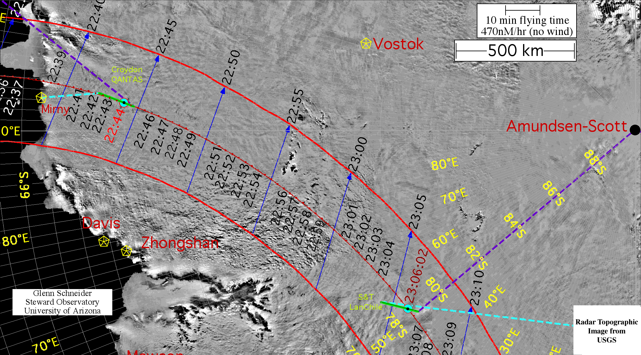
Representative "Totality runs" for Croydon/QANTAS 22:44:00
U.T. and S&T/LanChile 23:06:02 U.T., starting 8 minutes before and
ending 3 minutes after mid-eclipse, are shown schematically below.
These minimum duration totality runs were used in early baseline planning
in the evaluation of flight resources and requirements. The current plan
is to begin the totality runs at mid-eclipse minus 15 minutes and terminate
at mid-eclipse plus five minutes.
Croydon/QANTAS (22:44:00UT, left) and Sky & Telescope
/LanChile (23:06:02UT, right)
Baseline approach, intercept & totality, and departure tracks for
the eclipse flights planned for Crydon/QANTAS (B747-400; left) and S&T/LanChile
(A340; right).
Click on the above chart to see at twice the size (and resolution).
The key elements which define these critical portions
of each flight, and used in preparing the above chart, are given in the
two tables below with temporal granularities of 30 seconds. In both
cases flight altitudes of 38,000 ft. above mean sea level are assumed,
with aircraft ground speeds of 470 nM/hr with no wind. The no-wind
assumption is for planning purposes. Corrections and compensation for actual
winds-aloft may be computed by
EFLIGHT.
Both flights are planned so as to have the Sun "straight out" the sun-side
cabin windows at mid-eclipse, to provide maximum line-of-site visibility.
Alternatively, a path could have been chosen such that the the aircraft
were instantaneously flying in the direction of the umbral shadow's velocity
vector at mid eclipse. This would fully optimize the duration of
totality, but then the viewing angle to the Sun would be non-optimal (particularly
so in the case of the S&T/LanChile flight). Given the geometry
and circumstances of this eclipse, and the chosen intercepts, in these
cases the "loss" in the achievable duration of totality is inconsequential.
CROYDON / QANTAS BASELINE FLIGHT
U.T. Intercept: 22:44:00 | Cnt hh:mm:ss.f Alt°
P° Cnt hh:mm:ss.f Alt°
P°
Flight Altitude: 38000ft | 2ND 22:42:46.5 +14.9 109.4
3RD 22:45:20.1 +15.1 289.7
Air Speed: 470.0nm/h | LATITUDE:
-069° 51' 50.5'' LATITUDE: -070° 10' 21.9''
Wind Speed: 0.0nm/h | LONGITUDE:
+093° 12' 58.1'' LONGITUDE: +092° 54' 46.5''
Wind Direction: 0.0°| TOTALITY
DURATION = 2m 34.7s mid-Eclipse Heading: 198.63d
--------------------------------------------------------------------------------------
U. Time. ===================UMBRA=============== ==============AIRCRAFT==========
HH:MM:SS UM Lon UM Lat Width
SunAz SunAlt AC Lon AC Lat Mid*T
Mid*D
22:36:00 94.9014E 65.2706S 522.8km 110.0° 13.3°
94.0283E 68.9975S -480s -62.7nm
22:36:30 94.8944E 65.5814S 521.4km 109.8° 13.5°
93.9724E 69.0595S -450s -58.8nm
22:37:00 94.8738E 65.8896S 520.0km 109.7° 13.6°
93.9162E 69.1215S -420s -54.8nm
22:37:30 94.8396E 66.1955S 518.6km 109.5° 13.8°
93.8597E 69.1835S -390s -50.9nm
22:38:00 94.7919E 66.4991S 517.2km 109.4° 13.9°
93.8029E 69.2455S -360s -47.0nm
22:38:30 94.7304E 66.8005S 515.8km 109.3° 14.0°
93.7457E 69.3074S -330s -43.1nm
22:39:00 94.6552E 67.0997S 514.4km 109.2° 14.1°
93.6882E 69.3693S -300s -39.2nm
22:39:30 94.5661E 67.3970S 513.0km 109.0° 14.2°
93.6304E 69.4313S -270s -35.3nm
22:40:00 94.4628E 67.6922S 511.7km 109.0° 14.3°
93.5723E 69.4931S -240s -31.3nm
22:40:30 94.3452E 67.9855S 510.4km 108.9° 14.4°
93.5138E 69.5550S -210s -27.4nm
22:41:00 94.2129E 68.2769S 509.1km 108.8° 14.5°
93.4549E 69.6169S -180s -23.5nm
22:41:30 94.0658E 68.5664S 507.8km 108.8° 14.6°
93.3958E 69.6787S -150s -19.6nm
22:42:00 93.9035E 68.8542S 506.6km 108.7° 14.7°
93.3362E 69.7405S -120s -15.7nm
22:42:30 93.7257E 69.1401S 505.3km 108.7° 14.8°
93.2764E 69.8023S -90s -11.8nm
22:43:00 93.5319E 69.4244S 504.1km 108.7° 14.8°
93.2161E 69.8640S -60s -7.8nm
22:43:30 93.3217E 69.7068S 503.0km 108.7° 14.9°
93.1556E 69.9258S -30s -3.9nm
22:44:00 93.0946E 69.9875S 501.8km 108.7° 15.0°
93.0946E 69.9876S +0s +0.0nm
22:44:30 92.8502E 70.2665S 500.7km 108.8° 15.0°
93.0337E 70.0492S +30s +3.9nm
22:45:00 92.5879E 70.5437S 499.6km 108.8° 15.1°
92.9731E 70.1110S +60s +7.8nm
22:45:30 92.3071E 70.8191S 498.5km 108.9° 15.1°
92.9129E 70.1727S +90s +11.8nm
22:46:00 92.0072E 71.0927S 497.5km 109.0° 15.1°
92.8530E 70.2345S +120s +15.7nm
22:46:30 91.6875E 71.3645S 496.5km 109.1° 15.2°
92.7935E 70.2963S +150s +19.6nm
22:47:00 91.3473E 71.6345S 495.5km 109.2° 15.2°
92.7343E 70.3582S +180s +23.5nm
SKY & TELESCOPE / LanChile BASELINE FLIGHT
U.T. Intercept: 23:06:02 | Cnt hh:mm:ss.f Alt°
P° Cnt hh:mm:ss.f Alt°
P°
Flight Altitude: 38000ft | 2ND 23:04:51.6 +11.8 109.6
3RD 23:07:18.6 +11.9 283.9
Air Speed: 470.0nm/h | LATITUDE:
-078° 36' 17.6'' LATITUDE: -078° 48' 50.7''
Wind Speed: 0.0nm/h | LONGITUDE:
+052° 22' 0.5'' LONGITUDE: +051° 05' 57.7''
Wind Direction: 0.0°| TOTALITY
DURATION = 2m 26.1s mid-Eclipse Heading: 230.05d
--------------------------------------------------------------------------------------
U. Time. ===================UMBRA=============== ==============AIRCRAFT==========
HH:MM:SS UM Lon UM Lat Width
SunAz SunAlt AC Lon AC Lat Mid*T
Mid*D
22:58:02 76.4775E 76.8987S 481.9km 119.3° 14.3°
55.7230E 77.9970S -480s -62.7nm
22:58:32 75.3431E 77.0870S 481.7km 120.2° 14.2°
55.4945E 78.0417S -450s -58.8nm
22:59:02 74.1563E 77.2681S 481.5km 121.2° 14.1°
55.2644E 78.0862S -420s -54.8nm
22:59:32 72.9158E 77.4416S 481.3km 122.2° 14.0°
55.0325E 78.1305S -390s -50.9nm
23:00:02 71.6644E 77.6016S 481.2km 123.2° 13.9°
54.7990E 78.1746S -360s -47.0nm
23:00:32 70.3150E 77.7583S 481.1km 124.3° 13.8°
54.5637E 78.2185S -330s -43.1nm
23:01:02 68.9089E 77.9057S 481.1km 125.5° 13.6°
54.3267E 78.2623S -300s -39.2nm
23:01:32 67.4458E 78.0429S 481.1km 126.8° 13.5°
54.0879E 78.3058S -270s -35.3nm
23:02:02 65.9257E 78.1692S 481.2km 128.1° 13.3°
53.8474E 78.3492S -240s -31.3nm
23:02:32 64.3487E 78.2839S 481.3km 129.4° 13.2°
53.6051E 78.3923S -210s -27.4nm
23:03:02 62.7158E 78.3862S 481.5km 130.8° 13.0°
53.3611E 78.4352S -180s -23.5nm
23:03:32 61.0283E 78.4752S 481.7km 132.3° 12.8°
53.1152E 78.4780S -150s -19.6nm
23:04:02 59.2880E 78.5500S 481.9km 133.8° 12.6°
52.8676E 78.5205S -120s -15.7nm
23:04:32 57.4974E 78.6097S 482.2km 135.4° 12.5°
52.6181E 78.5628S -90s -11.8nm
23:05:02 55.6598E 78.6534S 482.5km 137.0° 12.3°
52.3668E 78.6049S -60s -7.8nm
23:05:32 53.7787E 78.6799S 482.9km 138.7° 12.0°
52.1137E 78.6468S -30s -3.9nm
23:06:02 51.8587E 78.6884S 483.3km 140.4° 11.8°
51.8587E 78.6885S +0s +0.0nm
23:06:32 49.9048E 78.6778S 483.8km 142.1° 11.6°
51.6038E 78.7301S +30s +3.9nm
23:07:02 47.9226E 78.6468S 484.4km 143.9° 11.3°
51.3506E 78.7720S +60s +7.8nm
23:07:32 45.9181E 78.5945S 485.0km 145.7° 11.1°
51.0994E 78.8141S +90s +11.8nm
23:08:02 43.8979E 78.5195S 485.6km 147.5° 10.8°
50.8499E 78.8564S +120s +15.7nm
23:08:32 41.8690E 78.4207S 486.3km 149.3° 10.5°
50.6022E 78.8989S +150s +19.6nm
23:09:02 39.8383E 78.2965S 487.1km 151.1° 10.2°
50.3564E 78.9416S +180s +23.5nm