Figure 1. The Path of the 23 November 2003 Total Solar
Eclipse at 40,000 ft. above MSL.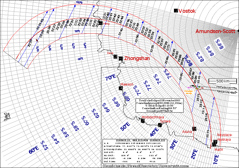
Glenn Schneider
Steward Observatory
933 N. Cherry Avenue
University of Arizona
Tucson, Arizona 85750
gschneider@as.arizona.edu or gschneider@mac.com
For background information see:
a) A description of the EFLIGHT
eclipse planning and navigation software.
b) Preliminary
Considerations for Airborne Eclipse Observation of the 23 Nov 2003
Total Solar Eclipse
The entire path of totality for the 23 November 2003 total solar eclipse is shown in Figure 1 as the shadow is projected onto a surface 40,000 feet above the Earth's surface. Times along the centerline give the topocentric instants of mid-eclipse (Universal Time). Because the Moon's umbral shadow is projected "over the pole" it sweeps across the Earth from east to west across Antarctica ("backward" with respect to most eclipses). The blue lines show are iso-temporal instants of mid-eclipse (crossing selected locations on centerline) between the path limits. The arrows indicate the corresponding line-of-sight directions to the Sun, with the arrow tips along the "southern" limit. The (lower right) inset, upon which a possible flight intercept profile has been annotated, is shown in Figure 2 in more detail.
Figure 1. The Path of the 23 November 2003 Total Solar
Eclipse at 40,000 ft. above MSL.
The flight under consideration, possibly using an Airbus 340 aircraft, launches from Puenta Arenas, Chile (Latitude = 51.13S, Longitude = 70.917W). For evaluation purposes a mid-eclipse intercept for 2310 UT has been considered. This intercept point is somewhat arbitrary and additional intercept points can be similarly evaluated once some of the details of aircraft availability, performance, and flight operations regulations are better established.
Under this scenario, the aircraft will depart Puenta Arenas on a great circle bearing of 162° 45.3' and fly a distance of 4779 km (2580.5 nM). Assuming a nominal ground speed at full cruise of 470 nM/hour, and allowing 20 minutes for departure and ascent this outbound leg of the flight would take appx. 5h and 45m. After this time the aircraft will execute a turn to a new heading of 244.53° be completed at 2302 UT (8 minutes before mid-eclipse intercept) with the aircraft at a location of Latitude = 77.9417S, Longitude = 36.6568E and will be 63 nM from the mid-eclipse intercept point.
The aircraft will hold this heading for 12 minutes as the lunar shadow over takes it. Six minutes and fifty seconds after completing this heading alignment maneuver the leading edge of the umbral shadow will envelop the aircraft. Second contact will occur at 23h08m50s UT with the Sun nearly "straight out" the port side windows (+4.2° from orthogonal to the plain of the windows) and 9.6° above the astronomical horizon. Holding this heading, after flying an additional 9.1 nM (for 70 seconds) the aircraft and the lunar umbra will be coaxial concentric. At the instant of mid-eclipse (23h10m00s UT) the Sun will be at an azimuth of 154.5 degrees (90 degrees from the direction of flight), and still at 9.6° above the horizon. With no course corrections, third contact will occur 71 seconds later (9.3 nM further along the flight path) at 23h11m11s UT. The aircraft will continue to fly on this heading until 23h14m00s (having flown 31nM since mid-eclipse) to permit viewing of post third-contact limb-phenomenon with no change in attitude. Following this a small course change to a great-circle bearing of 241° 44.6' will put the aircraft on a course back to Puenta Arenas, which it will reach after flying an additional 4606 km (2487nM). The return flight from that point, including decent and landing will take about 5h 35m.
The above scenario assumes a true airspeed of 470 nM/hour throughout the cruise phase (including the totality run) of the flight. The central portions of the flight plan are schematically represented in Figure 2.
Figure 2. Contacts, Intercepts, Locations and Circumstances
for a 2310 UT mid-Eclipse Fight Plan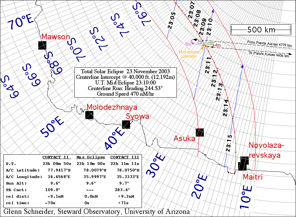
The second-by-second details of the intercept flight are graphically illustrated in the QuickTime movie below, which may be played by clicking on Figure 3. (Your web browser or auxiliary S/W must be capable of displaying QuickTime formatted files. A freeware QuickTime viewer for MacOS and Windows is available for immediate download from http://www.apple.com/quicktime if needed.) The graphical and accompanying textual display is fully explained on the EFLIGHT web page.
Figure 3. Animated EFLIGHT plan +/- 2 minutes from mid-eclipse.
Click on the image below to run.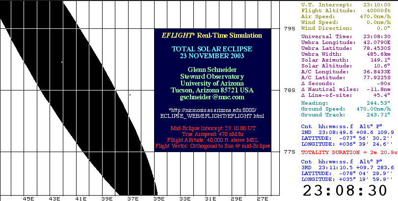
The above EFLIGHT plan and summary description are meant to representative for a single flight profile with a number of a priori assumptions and static parameters. Detailed dynamical flight plans, and navigation aids for in situ real-time replanning (if necessary) are provided by EFLIGHT. To make such a flight a reality, all I need is a seat (actually NO seat, but a window) on a range-capable aircraft.
Last Update: 14 August 2002