 |
 |
 |
|
|
|
|
The images which are presented and discussed on this page have been compositited and mosaiced into a single "all in one" poster, shown at 1/16 the size (and only at 72 dpi for web-based viewing), below. Clicking on the image below will bring up a 2x larger (1/8 size) display (but still at 72 dpi).

A full size (31.5" x 45.9" image on 32" x 48") rendered at 300 dpi on photo quality stock is available (contact Glenn Schneider by email for more information).
I'll read the background information that
follows
later, Go to the Eclipse Pictures...
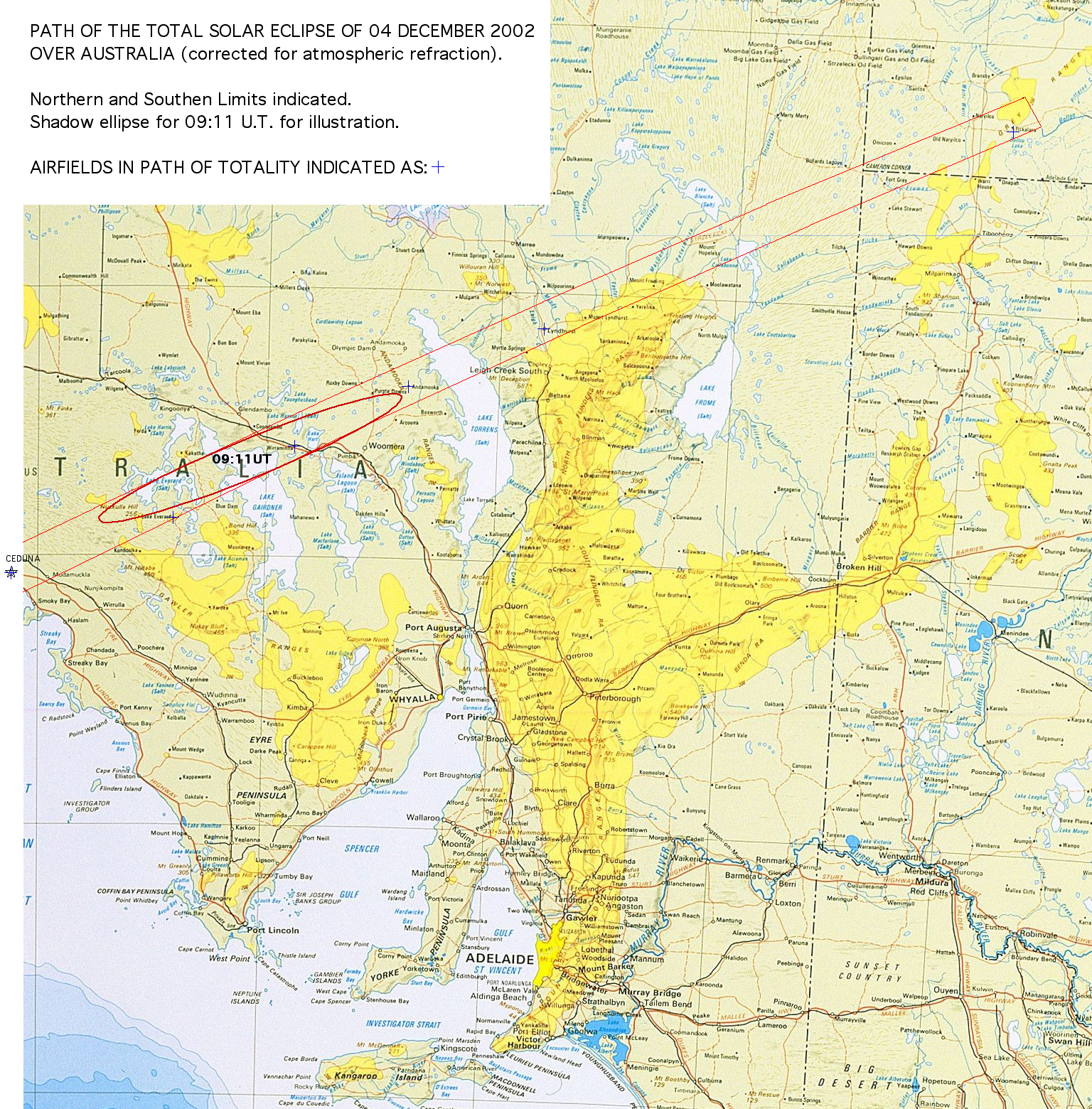
PATH: The path of the total solar eclipse of 04 December 2002 spanned two continents, Africa and Australia. The maximum duration of the total phase of the eclipse in Africa exceeded the approximately half minute one could have experienced in Australia, by a factor of three on the Mozambique coast as the lunar shadow headed out over the Indian Ocean. And, the maximum elevation of the Sun at mid-eclipse in Australia (at the coast) was only 9-degrees, and declined as the path progresses inland toward the outback (compared to a maximum of 45 degrees on the east African coast). If duration and solar elevation were the two principal factors in selecting an eclipse observation site the choice would be obvious. However, in this case, these were not the overriding criteria.
CLIMATE: To maximize the probability of seeing an eclipse, consideration of the climatology of the target areas and the need for maintaining mobility and flexibility are paramount. Noting, of course, the caveat that "climate is what you expect, weather is what you get". The later is particularly true as localized weather phenomena in regions affected by the decline of solar insolation during an eclipse are not well represented by statistical examinations of climatalogical (or meteorological) data. None-the-less, it was quite clear that potential for near-sunset clear skies the inland regions of Australia exceed those found along the track anywhere in Africa (particulary so given the horrific and nearly unprecedented drought gripping the Australian outback).
AFRICA: It had been suggested that in a few isolated spots on the African continent, such as near Beithbridge in Zimbabwe, that the chance of "clear skies" might have been as high as 60% based upon the normal mid-morning "mixing" model for cloud convection and formation. During this time of year, the onset of the southern African rainy season with higher humidity, cold-air advection brought on during the eclipse muddied the waters (if I may mix metaphors, if not the atmospheres) and the likelihood of cloud formation could increase over the nominal and usual scenario. It would certainly have been wise for anyone electing an African observing venue to have remained aggressively mobile, and happily may successes were reported. But, as many of us learned first-hand in our treks to the 21 June 2001 eclipse, where the path was very similar (in Africa) to that of this years event, mobility in that part of the world can be particularly "challenging". And, given the accelerating political instability in Zimbabwe (in particular) this, sadly, made this less than desirable choice for some foreign travelers.
AUSTRALIA: In contrast, the inland regions of
Australia
eastward of the Torrens salt lake bed offered very dry conditions
during
the austral summer season, with mean cloud cover reaching as low as 20%
(and best at the eastern extremedy of the path). On the Australian
coast
cloud cover was "expected" at about 50%, though here too
convectionally
driven cooling of the late afternoon moist sea air increased the
likelihood of coastal cloud. Moving eastward along the path of
totality,
in Australia, the altitude of the sun declined so the "likelihood" of
an
obscuring cloud along the line-of-site increased (all other things
being
equal), which biases these statistics. When the low solar
elevation
is taken into consideration, inland sites were still significantly
preferential
to the coastal region. For these reason, evaluating the
likelihood
of a view of the sun unobscured by intervening cloud, the eastern end
of
the path of totality in Australia "shone" as the preferential location
for an eclipse viewing site. With the ability to flee westward
(i.e.,
remaining aggressively mobile) to react in situ to local weather
conditions,
this is where our band of eight umbraphiles headed for the 04 December
2002 eclipse - the Australian outback in the region of Cameron's corner.
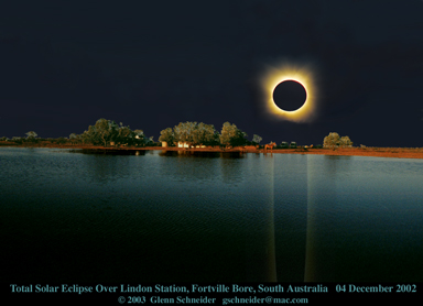
For some eclipse chasers the mantra is "duration, duration, duration". For me, like a real estate agent (which I am not) it is "location, location, location". At this point it would be useful to look at a more detailed MAP OF THE PATH OF TOTALITY OVER AUSTRALIA (2.3Mbytes, patience please). Electing to observe from Australia meant accepting a duration of totality of approximately half a minute. From the coast, near Ceduna, the centerline duration of totality is about 33 seconds. At the (refraction corrected) sunset point, near Tickalara, totality was about 24 seconds. One can look at this as either a half-empty, or half-full glass, depending upon your philosophy of life. I.e., this can be viewed as a "loss" of nine seconds (27% of the duration of totality at Ceduna), or as a weather-driven opportunity to witness a total solar eclipse at (or very near) sunset. This is something I have always wanted to experience, purely from the esthetic (some may say ethereal) perspective, but was unwilling, previously, to offer up a sacrificial eclipse. Indeed, for all other eclipses I have observed the regions at or near the sunset (or sunrise) points were always contraindicated due to weather (as well as, secondarily, duration).
To see the totally eclipsed sun just above the horizon, looming large by the "moon illusion", oblate from differential refraction, and with a golden-yellow corona from chromatic extinction was a tantalizing thought (and sight!). Moreso when totality would be framed in a conical wedge of darkness from the relatively narrow umbral shadow stretching through a nearly horizontal plane in the atmosphere. The thought of the view of the black ball of the moon, swiftly racing across the face of the Sun down "God's bowling alley", was like a siren's call to eclipse chasers who wanted to see a "different kind" of eclipse. At third contact with the the "lower" edge of the Sun hovering over the horizon the diamond ring would form emersed in a slender chromospheric crescent. Then, after totality, the umbral shadow would lift UP into space. A darkened oval rising ever higher as our spot on the Earth turned "down and away" from the "bottom" of the umbral cone which was slicing upward through the rising layers of the upper atmosphere. Minutes later the slender photospheric crescent would descend below the horizon, with the prospect of a green flash (or two) at the cusps(s). Then, in the first moments of twilight the sky would brighten with the re-emergence of the Sun below the horizon, before we would be cast into the darkness of a rapidly decending night.
This was what we had hoped for... and with luck and perseverance is what we saw!
Planning for this event occupied much time over the course of the year prior. The basic scenario was to drive from Sydney/Canberra to our eclipse viewing site in rented 4-wheel drive camper vans to Ft. Grey, just east of the South Australia, New South Wales border in Sturt National park. There we would have two chartered light aircraft standing by as a means of rapid "escape" in the event of cloud (as the "road" network in much of the outback is rather sparse, to say the least, and overland travel can be very slow and difficult). From Ft. Grey we would see the eclipse 1.3 degrees above the horizon at totality. However, only days before departing from the U.S. we were informed by the park ranger that the airstrip at Ft. Grey had become unusable (due to recently formed large ruts in the strip) and it would be very ill-advised to consider using it. Plan "B" emerged, after in situ consideration of alternate viewing sites. We investigated several possibilities even further east - but at the point where the few tracks crossed centerline the likelihood of scrub vegitation blocking the view toward the Sun even lower toward the horizon - made this nearly problematic (though we have learned that some did meet with success from one of these sites!). In the end we elected to observe from Lindon Station, near the Fortville Bore on the South Australia side of the Cameron's Corner three-state confluence.
Lindon station is a ranch property run by the Ogilvy's, whom I had contacted nearly a year before the eclipse to inquire as to the possible use of a private landing strip on their property at "Bollard's Lagoon". As things had evolved I had not expected to follow-up on that, but the necessity of selecting a back-up site had proven this had been a prudent early contact. I must say here that the Ogilvy's hospitality was exceptional and so much more than we could have anticipated, opening up their property, their home, and their facilities to us on such short notice. Lindon Station, is one of those outback "ranches" you hear about - but cannot quite conceive until you see it first hand. I have been on farm property in the U.S. which (then) seemed to me quite extensive. The extent of Lindon station is not measured in acers or hectares, but, well, it's 1,700 square miles! It WAS until recently 2,300 square miles but the Ogilvy's recently gave 600 square miles of the property back to the government to become national park land. The incredibly harsh conditions of the desert outback region only hits you when your realize that this one ranch, larger than some countries, sustains only about 200 head of cattle - such is the scarcity of water and foliage in this incredibly dry and terribly baron region. Images of the great U.S. "Dust bowl", as awful as that was, seems to pale in comparison. Immediately AFTER the eclipse, all of use offered a prayer for rain - something Lindon station hasn't seen in two years.
To say this location is in "the middle of nowhere" may be overstating - but it is pretty much as far from anywhere as you can get. There is one "store" about 20 km away at Cameron's corner, where New South Wales, South Australia, and Queensland meet - but other than that the nearest "town" is Tibuborra, several hundred kilometers and a day's drive away. Tibuboora itself is billed as the last outpost before the vast stretch of the Australian outback - and indeed it is.
The site was phenomenal for eclipse viewing, offering a virtually dead-flat 360 degree horizon, from a somewhat elevated and isolated "hill" (really just a rise in the local terrain) about 1.5 km off centerline - about the same distance from the Ogelvie's homestead at Lindon Station. Specifically we observed the eclipse from: LATITUDE: -029° 07' 53.0'', LONGITUDE: +140° 53' 50.0'', ALTITUDE: 120 meters, and had beautifully clear skies right to the horizon for the eclipse.
For this, my twenty-third total solar eclipse, I was joined by a band of six like-minded eclipse-seasoned veterans. This group (below, left to right) included: Joel Moskowitz(USA), Jay Friedland (USA), Glenn Schneider (USA), Joe Cali (Australia), Craig Small (USA), Michael Gill (England), and Bengt Alfredson (Sweden).
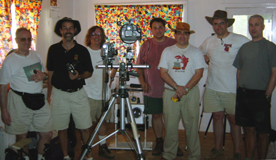
Clear Weather and All Smiles: Preparing Equipment for the Eclipse.
(Photograph courtesy of David Ogilvy)
This was one (if not the) finest assemblage of extraordinary people it has ever been my pleasure to travel with. Though due thanks are offered to all for their camaraderie and assistance in may aspects of our trip - a moment of special thanks to Joe. As our one "local" his familiarity with the roads, infrastructure, etc. was invaluable. How lucky can you get to meet up with someone who is (a) an eclipse chaser, (b) intimately familiar with the region to be visited, (c) equally familiar with off-road and remote travel in that region, (d) a nature and eclipse photographer, and (e) an all around affable and good-guy who bent over backwards to make sure many of the "little things" so necessary to success were not forgotten. Thanks Joe!
Click HERE if you would like to better connect faces to possibly familiar names (through SEML or elsewhere) as they prepare for the eclipse at our observing site.
My goal for this eclipse was to watch and enjoy it. As recently as two months before our intercept with the lunar shadow I has said (to Joel, in particular) that I was just going to watch this one, likely only bring a pair of binoculars - if that much - and leave the equipment behind. He didn't believe me. He was right. For some reason the need to capture coronal photons on silver halides (no... I haven't gone digital yet) is overwhelming. So, I compromised and brought a "modest" only TWO CAMERA setup to Australia, concentrating on photographing the eclipse itself, and leaving wide-field (horizon and shadow effect) photography to others. Of course, I did NOT break my promise to myself, and my cameras were run - once again - by UMBRAPHILE - so I was free to watch the eclipse during the fleeting moments of totality. What can I say? There ain't nothing' like a Mac. If you are unfamiliar with UMBRAPHILE read all about it HERE.
I've detailed the equipment and photographic program on a separate page. If you are interested in how the images which are presented below were acquired click HERE to read all about it.
Note: The JPG images shown below are reduced significantly in resolution to permit web-based viewing without excessive download time. In-line mosaics are 10% and individual images are 25% of the original resolution (and linear scale). For some of these, larger scale JPGs are provided, linked to the in-line images - but still reduced in resolution compared to the originals. FULL RESOLUTION TIFF files of these images *MAY* be downloaded with prior permission from Glenn Schneider. If you would like access to the FULL RESOLUTION TIFF DIRECTORY of images contact Glenn Schneider (gschneider@mac.com).
These images are provided for your personal use,
information,
and enjoyment. These images, and those linked from this page, or
in the full resolution directory, may *NOT* be reproduced for
commercial
purposes without prior consent from Glenn Schneider.
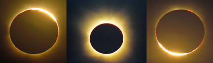
PRELUDE TO TOTALITY
(click on image mosaic for a larger view)

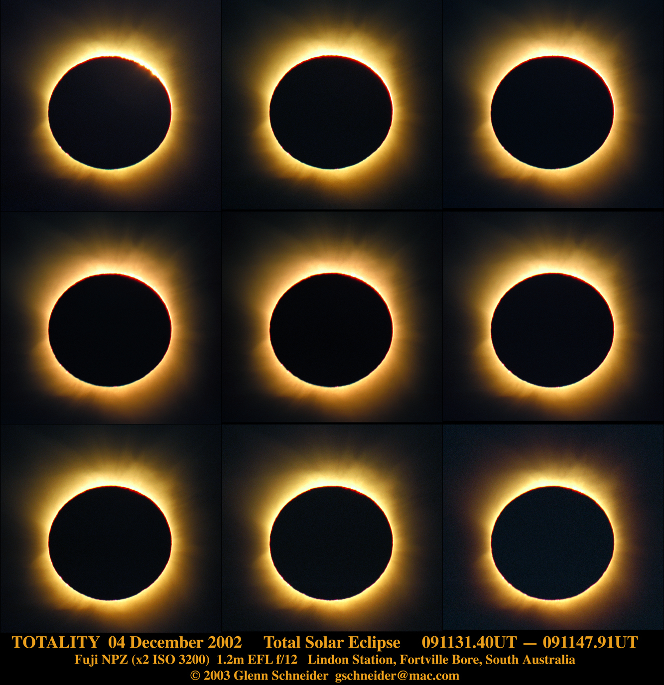
THE GLORY OF TOTALITY
(click on image for more information)
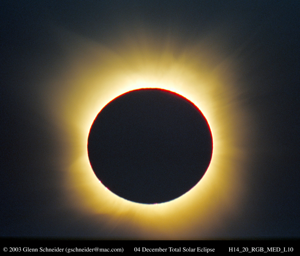
A composite from 7 of the 9 images of totality below.
FLEETING MOMENTS OF TOTALITY
The Beginning of the End of Totality
(click on the image for a larger view)

THIRD CONTACT : "Here Comes The Sun"
(click on image mosaic for a larger view)

SUNSET
(click on image mosaic for a larger view)
