
Sunset Expedition to Fort Grey, Australia
|
E-MAIL WEB |
|
E-MAIL WEB |
E-MAIL WEB |
Africa vs. Australian Coast vs. Australian Outback
The path of the total solar eclipse of 04 December 2002 spans two continents, Africa and Australia. The maximum duration of the total phase of the eclipse in Africa exceeds the appx. 1/2 minute one would experience in Australia, a factor of three on the Mozambique coast as the lunar shadow heads out over the Indian Ocean. And, the maximum elevation of the Sun at mid-eclipse in Australia (at the coast) is only 9-degrees, and declines as the path progresses inland toward the outback, compared to a maximum of 45 degrees on the east African coast. If duration and solar elevation were the two principal factors in selecting an eclipse observation site the choice would be obvious. However, these are not the overriding criteria.
To maximize the probability of seeing an eclipse consideration of the climatology of the target areas, and the need for maintaining mobility and flexibility, are paramount. Noting, of course, the caveat that "climate is what you expect, weather is what you get". The later is particularly true as localized weather phenomena in regions affected by the decline of solar insolation during an eclipse are not well represented by statistical examinations of climatalogical (or meteorological) data. None-the-less, it is quite clear that potential for near-sunset clear skies the inland regions of Australia at that time of year exceed those found along the track anywhere in Africa .
It has been suggested that in a few isolated spots on the African continent, such as near Beithbridge in Zimbabwe, that the chance of "clear skies" might be as high as 60% based upon the normal mid-morning "mixing" model for cloud convection and formation. During this time of year, the onset of the rainy season with higher humidity, cold-air advection brought on during the eclipse muddies the waters (if I may mix metaphors, if not the atmospheres) and the likelihood of cloud formation would increase over the nominal and usual scenario. It would be wise for anyone considering an African observing venue to remain aggressively mobile. But, as many of us learned first-hand in our treks to the 21 June 2001 eclipse, where the path was very similar (in Africa) to that of this years event, mobility is particularly "challenging". And, given the recently accelerating instability in Zimbabwe (in particular) this, sadly, could make a less than desirable choice for foreign travelers. In contrast, the inland regions of Australia eastward of the Torrens salt lake bed offer very dry conditions during the austral summer season, with mean cloud cover reaching as low as 20% (and best at the eastern extremedy of the path). On the Australian coast cloud cover may be "expected" at about 50%, though here too convectionally driven cooling of the late afternoon moist sea air would likely increase the likelihood of coastal cloud. As one moves eastward along the path of totality in Australia the altitude of the sun declines, so the "likelihood" of a cloud along the line-of-site increases, which would bias these statistics. When the low solar elevation is taken into consideration, inland sites are still significantly preferential to the coastal region. For these reason, evaluating the likelihood of a view of the sun unobscured by intervening cloud, the eastern end of the path of totality in Australia "shines" as the preferential location for an eclipse viewing site. With the ability to flee westward (i.e., remaining aggressively mobile) to react in situ to local weather conditions, this is where I will head for the 04 December 2002 eclipse.
Quality, Not Quantity
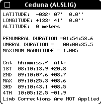
For some eclipse chasers the mantra is "duration, duration, duration". For me, like a real estate agent (which I am not) it is "location, location, location". At this point it would be useful to look at a more detailed MAP OF THE PATH OF TOTALITY OVER AUSTRALIA (2.3Mbytes, patience please). Electing to observe from Australia path means accepting a duration of totality of approximately half a minute. From the coast, near Ceduna, the centerline duration of totality is about 33 seconds. At the (refraction corrected) sunset point, near Tickalara, it is about 24 seconds. One can look at this as either a half-empty, or half-full glass, depending upon your philosophy of life. I.e., this can be viewed as a "loss" of nine seconds (27% of the duration of totality at Ceduna), or as a weather-driven opportunity to witness a total solar eclipse at (or very near) sunset. This is something I have always wanted to experience, purely from the esthetic (some may say ethereal) perspective, but was unwilling to offer up a sacrificial eclipse. Indeed, for all other eclipses I have observed the regions at or near the sunset (or sunrise) points were always contraindicated due to weather (as well as, secondarily, duration). To see the totally eclipsed sun just over the horizon, looming large by the "moon illusion", in a conical wedge of darkness from the relatively narrow (appx. 25km wide) umbral shadow stretching through a nearly horizontal plane in the atmosphere is a tantalizing thought. Then, at third contact the "lower" edge of the sun approaches the horizon near the point where the diamond ring from the soon-to-set very thin photospheric crescent will appear, and the umbral shadow lifts straight "up" into space. Yup, I'll be there. Any other takers?
The "Plan" - from the ground
Last year our small but dedicated band of die-hard Umbraphiles had such success in Zambia, that I advocated something similar for Australia. Again, no touristy "if it's Tuesday it must be Melbourne" and "oh, by the way there is an eclipse" whirl-wind sightseeing trip with a lot of tag-alongs for whom the eclipse is of secondary import. No. Rather, a nucleus of us, the enlightened, those who advocate "eclipse or bust" and will stand by that until the last coronal photon wanes. Of course we would welcome a "first timer" or two, if they are truly motivated by the eclipse. Clearly some of us would want to avail ourselves of the opportunities to explore "down under" but not at the expense of, or until after, the Champaign cork has popped, the egg creams have fizzed, and we are scratching our heads about how we get to Antarctica in 2003. So from hippos to 'roos. Are you game? The game is indeed afoot.
The "plan" in detail is still evolving, but in concept is now relatively mature. Michael Gill and I had been iterating Michael Gill for quite a while and we were driven (motivated) by a desire to observe totality from very near sunset at centerline. Recently, we fell in with Joseph Cali, an Aussie some of you may know from the Solar Eclipse Mailing List, who has first-hand familiarity with many of the logistics and transport "issues" which leap to mind. And, Joel Moskowitz has said "count me in", and thus, this is now our small band of die-hards heading for the hottest place I know of outside of Tucson. By the way by "very near the horizon", I mean we target for the Sun still being above the horizon at third contact, by about 1-1/4 degrees. Less than that, well, we're not absolutely crazy (though some may disagree) - but read on.
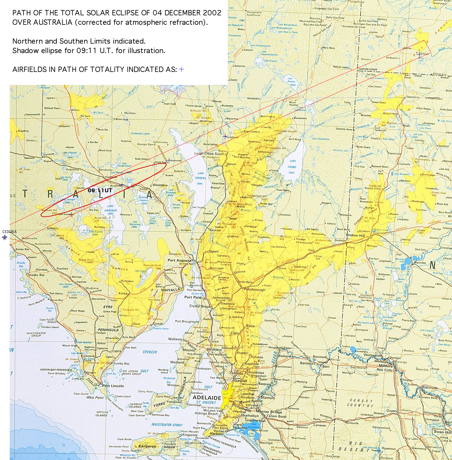
Before getting too specific (which I will) it is worth looking at the above linked map now if you have not done so. This is a "road map" of the region covering the path of totality with northern and southern limits overplotted. The path (which has been corrected for atmospheric refraction) "ends" at sunset just NE of Tickalara. You will note a number of blue "+"'s in the path. These are airfields in the path of totality, more on that later too. You probably have noted the paucity of roads and the sparseness of the road network at the eastern end of the path. Thus, the "basic" plan is that we will converge in Canberra (where Joe Cali lives) on November 30th. There we will pick up (at least) two 4WD vehicles. Joe has his own, and we are gong to rent a camper van, either this model or something similar to travel to our "prime" pre-selected viewing site, which is on centerline near Fort Grey (be sure to click on this link for information on Fort Grey). Two vehicles, of course, is a minimum. One would be downright fool hardy as we cannot risk a vehicle breakdown stranding us outside of the path of totality. If more people (within limits!) end up joining us in this venture we will up the number of vehicles.
Conservatively, we would make our way to and base in Port Augusta (or Broken Hill) two days before the eclipse. IF at that time of our departure to Fort Grey there is a clear and unambiguous reversal in anticipated weather conditions we would head westward toward Ceduna. IF not, however, we would take the following route, with drive times noted by Joe Cali (who has provided very helpful comments regarding 4WD travel in the area which should be seen by anyone considering overland travel along the path of totality):
a) Port Augusta SE to Peterborough
JC: 120km About 1.5 .- 2 hrs
b) Barrier Highway NE from Peterborough to Broken Hill
JC: Good condition, sealed & fast 270 km 3 - 5 hrs
c) Silver City Highway N from Broken Hill to Tibooburra
Tibooburra is our "gateway to totality". It is one of (if not the) most remote, and hottest, towns in Australia. Tibooburra is outside of the path of totality, but is the logistical "local" staging point for our final assault.
JC: Distance 340km. Time 4- 6 hrs. Condition - pretty good and sealed part of the way. Conditions get a little worse the further north you go. In a top heavy camper 4wd you probably shouldn't travel over 60-70km per hour once you hit the unsealed roads.
d1) Tibooburra to centerline near Fort Grey (about two hours drive time).
{Joe also provides additional drive time info for a more direct routing from Canberra.}
FORT GREY. At Fort Grey
is in Sturt
National Park. The elevation of the Sun, there, is 1.3 degrees
above the horizon at mid-eclipse and might offer a bit more comfortable
"breathing room" against any horizontal obstructions than sites further
East. I have not yet seen a topo myself to see what may lie in the line-of-site
in the direction of the Sun, but Joe Cali now has and reports: "I checked
the maps. The airstrip and the point where the road crosses the
centerline have low horizons. FG airstrip: 10m high sandridges
11 kilometres away @ az = 243deg, Ft Grey: 10m high sandridges 15 kilometres
away @ az = 243deg. There will be similar 10m sand ridges nearby."
We could climb them for a bit of extra elevation if necessary. This site
is accessible
by a road and may be seen on a larger area
road map also showing its location w.r.t. Tickalara. Note:
From centerline, 5' to the north of the Fort Grey landing strip along the
road landing strip along the road, the duration increases by 3 seconds
(to 26.2 seconds prior to limb corrections).
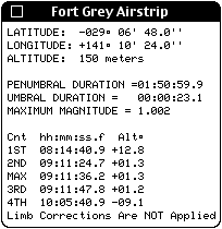 Local
circumstances (left) for the Airstrip at Fort
Grey, which has two 900 x 30 runways, heading 8/26 and 3/21, (information
graciously provided by: Bill Harvey, Public Affairs, Department of Transport
& Regional Services, (02) 6274 7860, Bill.Harvey@dotrs.gov.au, and
Gary Oldman, Information Technology Manager, Royal Flying Doctor Service
(SE Section), Ph 08 8080 1718, Fax 08 8088 4536, gary.oldman@rfds.gov.au).
The somewhat off-centerline airstrip is in the path of totality and located
at: Longitude = 141° 10' 24"E, Latitude = 29° 06' 48"S, with the
advisory "sand hills in vicinity of strip".
Local
circumstances (left) for the Airstrip at Fort
Grey, which has two 900 x 30 runways, heading 8/26 and 3/21, (information
graciously provided by: Bill Harvey, Public Affairs, Department of Transport
& Regional Services, (02) 6274 7860, Bill.Harvey@dotrs.gov.au, and
Gary Oldman, Information Technology Manager, Royal Flying Doctor Service
(SE Section), Ph 08 8080 1718, Fax 08 8088 4536, gary.oldman@rfds.gov.au).
The somewhat off-centerline airstrip is in the path of totality and located
at: Longitude = 141° 10' 24"E, Latitude = 29° 06' 48"S, with the
advisory "sand hills in vicinity of strip".
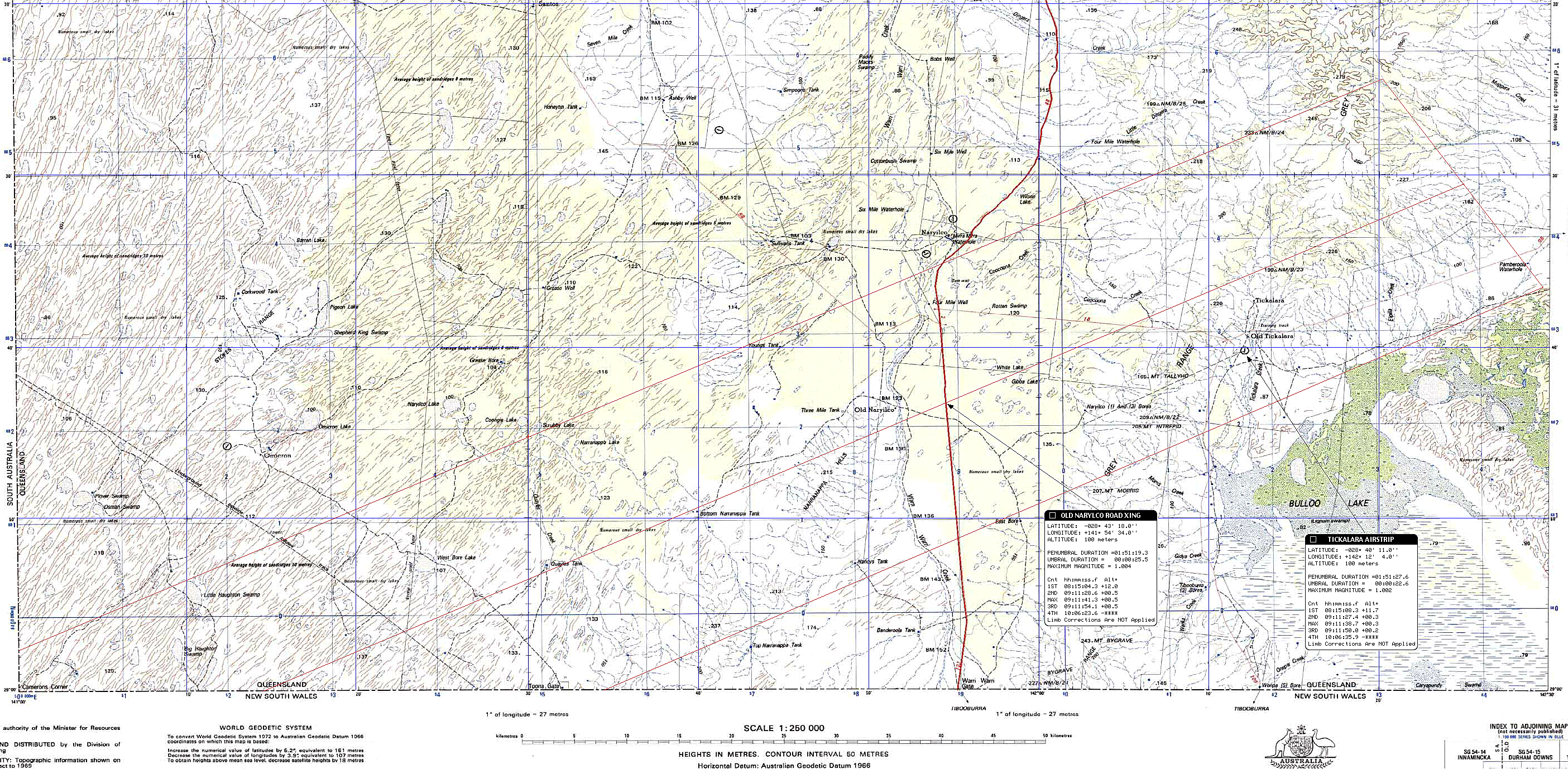
d2) Continue North (unimproved?) road to centerline just east of Old Nariyilko
OLD NARIYLKO. "Bottom Narrabappa
Tank", on centerline near Old Nariylko and is is a possible viewing
site. However, with the sun only 1/2 degree above the astronomical
horizon , and < appx. 1/5 degree above the local topographic horizon,
at mid eclipse. That was a bit too close for us, and we vetoed this site
in favor of the slightly more westerly Ft. Grey. Do see the information
on this, the Tickalara/Old Nariyilko/Bottom
Naranappa site, though. And, also, a 250:000,1 topographic
map of the sunset end of the path of totality
near Tickalara.
The Backup - The Escape (Plane)
Once at a specific site in the path of totality, particularly
further toward the east, an overland "escape" to avoid unexpected clouds
on eclipse day would be difficult. The rate which one could back-track
to the west by going overland off-road (with a 4WD of course) is
likely < appx. 10km/hr. Indeed, fleeing even a "modest" distance
from Fort Grey, off-road could take much too long. We could backtrack
through Tibooburra (see this MAP
too) to reach another centerline (or at least in-the-path site, but we
really would want to be able to move further faster. Hence: the escape
plane - a light aircraft standing by at, or very near, our
PRIME observing site capable of transporting us from there to another in-the-path
site on very short notice. Of course this would mean leaving our
vehicles at the prime site (or airstrip close to it) and observing from
an airstrip where would would land as we would have no local transportation
there. This would include the possibility of flying as far as Ceduna
if necessary (and hence loosing the "sunset" aspect of the eclipse).
The "alternate" air accessible sites in the path are limited. At
the moment, I have found only four which I have looked into. There
may be others, but this is under investigation - and further input from
any local pilots would be appreciated. The four sites with airstrips
under consideration, along with local circumstances of totality at those
locations are:
 |
 |
 |
 |
NOTES:
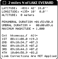 Additionally,
there is an airstrip at Lake Everard, right at at the southern limit of
totality. The approximate coordinates of this site (estimated from
a large scale map, so an [for now]
uncertainty of a couple of miles) are 135deg 10minE, 31deg 44mS for which
I compute a partial eclipse of magnitude 0.9995. However, if one
were to walk two miles to the north one would see a 10 second total eclipse.
Clearly, we need the actual airstrip coordinates (which I should have in
hand soon. If everywhere else is cloudy, as a last ditch effort (no pun
intended) we could land here and go walk-about into totality.
Additionally,
there is an airstrip at Lake Everard, right at at the southern limit of
totality. The approximate coordinates of this site (estimated from
a large scale map, so an [for now]
uncertainty of a couple of miles) are 135deg 10minE, 31deg 44mS for which
I compute a partial eclipse of magnitude 0.9995. However, if one
were to walk two miles to the north one would see a 10 second total eclipse.
Clearly, we need the actual airstrip coordinates (which I should have in
hand soon. If everywhere else is cloudy, as a last ditch effort (no pun
intended) we could land here and go walk-about into totality.
Finally, very near sunset, there are two airstrips at Naryilco just north of northern limit. Naryilco (a), Lon = 141deg 53.5minE, Lat = 28deg 34.5minS; Narylco (b), Lon = 141deg 55.0minE, Lat = 28deg 32.5minS. From the more southern one (a), a 1 mile walk will bring you into the path of totality.
In the even of low-level obscuring cloud over the entire path, or "last-minute" cloud on the horizon at the prime site, the "escape" aircraft could be used to observe the eclipse from the air. We are not talking a high altitude jet as we used in in 1986 or 1992, but here a small prop could save the day.
Ready, Set...
So, now our Sunset Expedition is a band of four hardy Umbraphiles. I suspect not too many eclipse chasers would plan an observation only with the sun only 1.3 degrees above the horizon. But given the weather prospects, the weather contingencies we have put in place (and, if the weather dictates we could end up in Ceduna anyway where the vast majority seem to be headed), and this is something I have always wanted to do, it really could be glorious. So my 23rd total solar eclipse may indeed be the "low point" of my eclipse-chasing endeavors. I hope so, and I'll savor every of the 25 seconds of it. If you are similarly inclined do let me know. We are very seriously into the planning and arranges stages regarding resources, transportation, infrastructure, local contacts, etc. It would be wonderful to watch the umbra disappear at 09:11:48 UT "straight up" into space, and kiss it goodbye until we rendezvous with it again in the Antarctic.
Glenn Schneider
18 January 2002