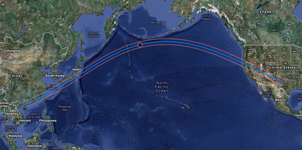
The 21-20 May 2012 Annular solar
eclipse (ASE 2012) is visible from parts
of southeast China (including Macau and Hong Kong soon after sunrise
May 21 local time), Taiwan (Taipai near southern
limit), Japan (Kagoshima, Osaka, and Tokyo on centerline), across the
north Pacific, and the southwest United States (May 20 local
time).
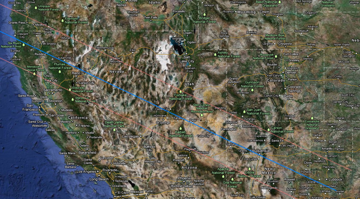
In the SW USA the annular eclipse may be seen northern California,
Nevada, southern Utah, northern
Arizona, the southwest corner of Colorado, New Mexico, and (at sunset)
western Texas.
CENTERLINE
VS. EDGE
Eclipse observers traveling into the path of annularity will usually
elect to position themselves either (a) on "centerline" (blue line on
maps above), (b) just inside the annular path limits (orange lines on
maps above), or (c) some locations in between of particular
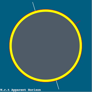
geographical interest. From centerline (a), the Moon will
traverse centrally across the angularly larger solar disk so as to lave
a concentric annulus of photospheric light surrounding the moon at
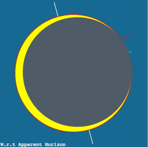
mid-eclipse. From just inside (~ 2 km) the northern or southern
limits, the moon's silhouette in front to the Sun at mid-eclipse will
have one limb of the Moon internally tangent to the solar limb at
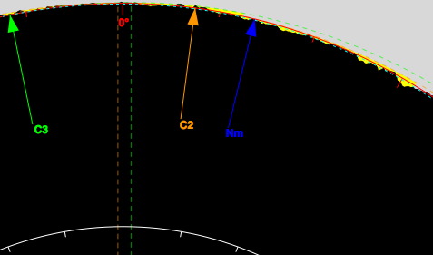
mid-eclipse. From here an extreme "solar crescent" will form with
the jagged edge of the moon (from its mountains and valleys in profile)
will cause a continually changing pattern beads of sunlight near the
point of tangency for ~ 2 minutes centered on mid-eclipse. (Click and
HERE and
HERE to see
videos of of near-limit Baily's beads from the May 10, 1994
annular solar eclipse).
|
|
 |
Mid-eclipse
on Centerline
(near Page, AZ)
|
Mid-eclipse
2 km inside southern limit
(near Winslow, Arizona)
|
Limb profile
detail at C2 near Winslow, Arizona
(solar North up in this display)
|
Above
graphics generated with Xavier Jubier's "Solar
Eclipse Maestro" S/W for MacOS X
|
Click HERE to see an animation of the progression of
the Moon across the Sun for +/- 5 minutes centered on
mid-eclipse as will be seen from just north of Winslow, Arizona (as
discussed below).
For ASE 2012 the plan is to observe from just inside southern limit to
see extended Balily's bead phenomenena with a prolonged C2-to-C3
internaly-tangent transit of the Moon's limb --
not from a centerline location.
CLOUD-COVER
EXPECTATION (AVOIDANCE)
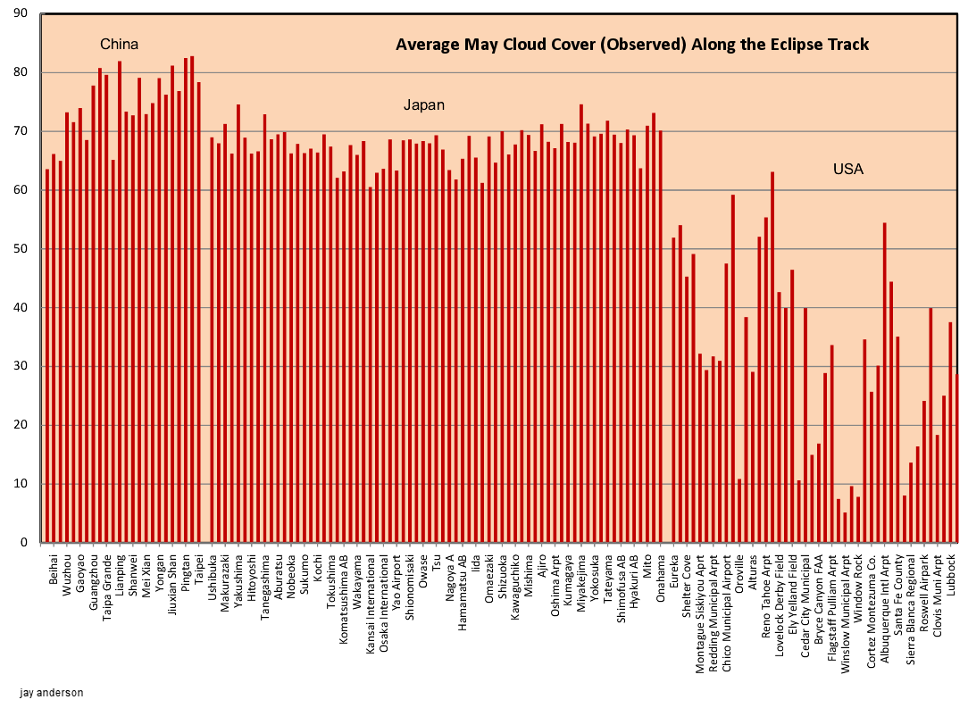
In the SW USA, the expectations for lack-of cloud cover are most
favorable for northern Arizona, and in particular for the region in and
around Winslow - a town which is itself located on the southern limit
of the path of annularity. See below monthly average cloud cover
statistics across the path of annularity for May as compiled by Jay
Anderson. See
Jay's
web site for more information.
May monthly cloud cover
percentage along the path of annularity - compiled by Jay
Anderson.
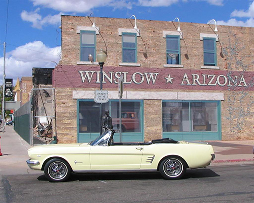
TAKE IT EASY (click):
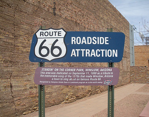
"WELL I'M STANDING ON A CORONER IN
WINSLOW, ARIZONA AND SUCH A FINE SITE TO SEE..."
Given then the statistically best likelihood for clear skies and the
fortuitous (for me) proximity to Tucson (where I am located, only about
a 5-1/2 hour drive), the "plan" (modulo near-term weather forecast
modification) is to observe ASE 2012 from just north of
Winslow, Arizona, 2 km (+/- 0.5 km)
north of Southern limit. From Winslow, eclipse first
contact (partial ingress phase) begins at 5:27 PM MST on the evening of
Sunday May 20. Mid-annularity is at 6:36 PM MST, and the sun will
set at 7:23 PM in 25% partial eclipse (exact times are given below).
In the annotated satellite photo below, showing the town of Winslow
with the southern limit of the path of annularity (red line) running
parallel to Interstate-40 and bifurcating the town, the red "X" marks
the eclipse-observation spot.
Winslow, southern limit, and observing
location ("
X" marks the
spot). North is up.
Click
HERE
for a larger, higher-reolution photo.
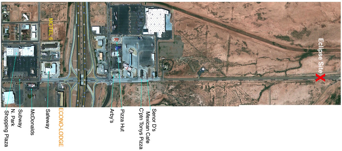
Close-up view of the observing area and local infrastructure.
North is to the right.
Click
HERE
for a larger, high-resolution photo.
WHY THIS SITE?
This specific 2-km north of southern limit location was chosen because
of:
(a) Logistical Considerations -- SEE detailed map/photo below
- very close proximity to motels (Econolodge,
Motel 6 both ~ 1 mile) and < 2 min drive to observing site
- very close proximity to (many) restaurants,
grocery stores, hardware stores, etc.
- very easy roadside access to viewing site on a
well maintained road (N. Park Rd).
- uncrowded immediate location devoid of
buildings and other obstructions
(b) Viewing and Contingency Considerations
- apparently unobstructed view in the
direction to the eclipse and down to the horizon
- ample open space for comfortably
setting up with immediate road-side parking access
- immediately proximate to major
interstate highway (I-40) "paralleling" southern limit
(in the event of contingency
re-location due to clouds or other circumstances).
See this in Google Maps: Click
HERE
SITE COORDINATES AND ECLIPSE
CIRCUMSTANCES
Latitude: 35° 03' 07.42" N
(+35.05206°), Longitude: 110° 41' 53.05" W
(-110.69807°)
Obscuration at Maximum Eclipse: 87.10%
Magnitude at Maximum Eclipse: 0.93326
Mean-Limb Annular Duration: 44.5 s
ECLIPSE EVENT MST Altitude
Azimuth PA VA
Contact I: 17:27:11
+21.8° 280.0° 274°
4.8°
Contact II: 18:36:19
+8.2° 289.0° 353°
2.0°
Max-Eclipse: 18:36:41
+8.1° 289.1°
2° 1.8°
Contact III: 18:47:02
+8.0° 289.1° 12°
1.5°
Sunset: 19:24:03
+0.0° 295.0° N/A N/A
Contact IV: Not Visible Below Horizon
ALTERNATE/CONTINGENCY NEARBY SITES
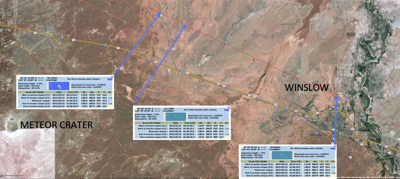
Two alternate/contingency sites (shown below), also 2 km north of
southern limit with easy access right off I-40 and good eclipse
visibility, have been identified 15-17 km west of the primary site
north of Winslow, about half-way toward the Barringer
METEOR CRATER
(which is outside of the path of annularity). CLICK
HERE for a larger, high-resolution
photo and photos of the two sites.
THE (current) "PLAN" (From Tucson)
Joel Moskowitz is arriving in Tucson on
May 18. We will be watching the weather (from Tucson) on May 18
and the morning of May 19. If good weather predictions for
northern Arizona hold, we will leave Tucson mid-morning (~ 10 AM or
earlier) on Saturday, May 19th, via route 79 to 87 into Winslow.
(If the weather looks bad for northern Arizona on the morning of May
19, but good elsewhere, e.g., New Mexico, we will elect for a "Plan
B").
The total driving distance to Winslow is 271 miles (from my house or
close to the same from my office on UofA campus) with
an estimated drive time of 5-1/2 and, so, arrival to the motel in
Winslow at or before about 4 PM. This will give us ample time to
check out the prime and alternate observing sites (or others, if any,
to relax at the hotel) at or before sunset on May 19 with then dinner
and an overnight stay in Winslow.
Joe, Renate, and Maria Rao awill fly into
Phoenix on Saturday May 19th, and drive up to Winslow to join us either
on the morning of the 20th.
Jay, Melissa, and Beno Friedland will be flying into Phoenix on the
morning (late morning) on eclipse day, Sunday May 20 and will meet up
with us in the early/mid afternoon in Winslow (it's about a 3-1/2 hour
drive from Phoenix to Winslow) or (if early enough) at the Meteor
crater (see below).
After breakfast on the morning of May 20 (eclipse day), we will drive
to the Barringer Meteor crafter (about 25 miles from the motel in
Winslow) for moring/early afternoon siteseeing (see the meteor crater
WEB SITE). We'll then have a
mid-afternoon lunch near the hotel and then set up for the
eclipse. 1st contact to sunset (after annularity) is 5:27PM -
7:24PM local (MST) time.
Joel has a 9:15 AM MST flight out of Tucson on Monday morning May 21,
so we will be leaving Winslow right after the eclipse to drive back to
Tucson. It should not take long at all to put cameras etc.
back in the car, grab a quick dinner down the road from the eclipse
site and be on the way back to Tucson by no later than 8 PM with an
arrival back into Tucson by 1:30 AM.
-- Glenn Schneider. Last update 29 March 2012
